More From Contributor

£3.50
Portishead North in 1930 in a fascinating series of reproductions of old Ordnance Survey plans in the Alan Godfrey Editions, ideal for anyone interested in the history of their neighbourhood or family. Portishead is covered on three maps. This title covers the northern part of the town, extending from Rockleigh & Kilkenny Bay eastward to Portishead Dock. Features include Woodhill, most of Portishead Dock, Pier, Royal Hotel, Portishead station, Portbury Wharf, engine shed, Marine Lake, Portishead Point, Adelaide Terrace, timber wharf. On the reverse is a list of private residents from a 1920s directory. About the Alan Godfrey Editions of the 25” OS Series Selected towns in Great Britain & Ireland are covered by maps showing the extent of urban development in the last decades of the 19th & early 20th century. The plans have been taken from the Ordnance Survey mapping & reprinted at about 15 inches to one mile (1:4, 340). On the reverse most maps have historical notes & many also include extracts from contemporary directories. Most maps cover about one mile (1.6kms) north/south, one & a half miles (2.4kms) across; adjoining sheets can be combined to provide wider coverage.FOR MORE INFORMATION & A COMPLETE LIST OF ALL AVAILABLE TITLES PLEASE CLICK ON THE SERIES LINK. ...
Archived Product
£3.50
Portishead West in 1930 in a fascinating series of reproductions of old Ordnance Survey plans in the Alan Godfrey Editions, ideal for anyone interested in the history of their neighbourhood or family. Portishead is covered on three maps. This title covers the western part of the town, stretching from the High Street westward to the Nautical College, & from Beach Road southward to Wetlands Lane. Features include West Hill, Dry Hill, Capenore Court, Greenfield Farm, Springfield Farm, St Peter`s church, National Nautical School, Nore House, Black Nore Point Lighthouse, St Barnabas church, convent, Blade Road. On the reverse is a commercial directory for Portishead. About the Alan Godfrey Editions of the 25” OS Series Selected towns in Great Britain & Ireland are covered by maps showing the extent of urban development in the last decades of the 19th & early 20th century. The plans have been taken from the Ordnance Survey mapping & reprinted at about 15 inches to one mile (1:4, 340). On the reverse most maps have historical notes & many also include extracts from contemporary directories. Most maps cover about one mile (1.6kms) north/south, one & a half miles (2.4kms) across; adjoining sheets can be combined to provide wider coverage.FOR MORE INFORMATION & A COMPLETE LIST OF ALL AVAILABLE TITLES PLEASE CLICK ON THE SERIES LINK. ...
Archived Product
£22.50
This is the only guide that covers all the climbs on the Isle of Portland & at Lulworth Cove. Whether it`s a sport climb, a trad route, a deep water solo, or a boulder problem, you`ll find it here. The bulk of the guide covers sport climbing, & interspersed between the sport climbs are a number of deep water solos. The traditionally protected routes are included in topo format for the first time too. &, for ease of use, separate sections of the guide describe the most worthwhile bouldering areas in detail. ...
Archived Product
£10.99
Portland
- Take a Hike in the Moon Outdoor Guides series; exploring a wide range of outdoor activities
- including camping,

...
Archived Product
£8.50
Portland & Willamette Valley in Oregon on a road map at approx. 1:385, 000 approx from the Great Pacific Recreation & Travel Maps, indexed for sights & attractions & with enlargements & several street plans. On one side is a road map centered on Portl&, including the adjoining area of Washington State around Vancouver WA, with an inset extending coverage along the Columbia River Gorge National Scenic Area to The Dalles & southwards to show the road loop around the Mt Hood National Forest. An enlargement provides more detailed mapping of the Portland conurbation & street plans show downtown Portl&, Hood River, Mc Minnville, Vancouver WA, Oregon City & Forest Grove. On the reverse coverage of the main map is extended from Salem to Eugene & further south to Cottage Grove. Enlargements and/or street plans cover Salem ...
Archived Product
£8.99
Portland Navigational Triangle 200mm Features protractor markings & compass points with reciprocals in red. The scale is in millimetres & it is manufactured from strong acrylic. Can be used in pairs as a Parallel Rule. Also available in 230mm size. For more information or to enquire about Blundell Harling products, please email us at maritime@stanfords.co.uk. ...
Archived Product
£11.99
Portland Navigational Triangle 230mm Features protractor markings & compass points with reciprocals in red. The scale is in millimetres & it is manufactured from strong acrylic. Can be used in pairs as a Parallel Rule. Also available in 200mm size. For more information or to enquire about Blundell Harling products, please email us at maritime@stanfords.co.uk. ...
Archived Product
£9.99
From the Downtown streets littered with strip clubs & gutter punks to the north side where gentrification & old school hip-hop collide, Portl&, Oregon is a place that seems straight out of a David Lynch movie. It`s a city full of police controversies, hippie artist houses & overzealous liberals, where even its fiction blurs with its bizarre realities. ...
Archived Product
£7.99
Portland in Oregon on an indexed street plan from Rand Mc Nally in their extensive range of maps covering cities in the United States. An inset shows downtown Portland in greater detail & another panel provides a road map of the Greater Portland area. Communities covered by this map include Beaverton, Gresham, Happy Valley, Lake Oswego, Milwaukie, Tigard, Troutdale, Tualatin & West Linn.NEW STREET PLAN CARTOGRAPHY FROM RAND Mc NALLY: Rand Mc Nally are currently changing the cartography of their street plans to a more “ European” style. In many titles streets are now shown by parallel lines, providing a much clearer, easier to read presentation. Better use of colouring indicates different types of land use and/or institutions (parks, shopping centres, academic institutions, etc) &, in most titles, different administrative units. More streets are annotated with block numbers. Some new editions still retain the traditional American presentation of streets by a single line, but with more prominent marking for various institutions, facilities & places of interest. Our cartography sample indicates which style is used in this title.COVERAGE: Rand Mc Nally street plans cover cities with their outer suburbs, prominently highlighting principal traffic arteries & connecting main streets. Railway & subway stations are marked. ...
Archived Product
£49.99
Portland Plotter Movable disc enables magnetic variation to be set on the instrument & a movable arm is divided into millimetres. With Captain Fields` protractor markings. Comfortably covers the largest Admiralty Chart with pencil guide holes give precision loction. Unique design ensures a truly parallel action & special ”slip & grip” gives ease of use. Manufactured from clear acrylic, 400mm in length. For more information or to enquire about Blundell Harling products, please email us at maritime@stanfords.co.uk. ...
Archived Product

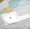
Portland Course Plotter

This course plotter is used worldwide by practical and shore based instructors. It features a bright blue directional arrow to prevent accidental reciprocal bearings and the edges are graduated for tide and boat speed.The base has a fixed grid so it is easy to plot latitude from your GPS system and it comes with comprehensive instructions for use.
RIP - This product is no longer available on our network. It was last seen on 25.09.2019

This page now acts as a permanent archive for this product. Add more information using the comments box below to ensure it can still be found by future generations.

Use our search facility to see if it is available from an alternative contributor.
  • External links may include paid for promotion
  • Availability: Out Of Stock
  • Supplier: Stanfords
  • SKU: 5020027060240
Availability: In Stock
£15.99

Product Description

This course plotter is used worldwide by practical & shore based instructors. It features a bright blue directional arrow to prevent accidental reciprocal bearings & the edges are graduated for tide & boat speed. The base has a fixed grid so it is easy to plot latitude from your GPS system & it comes with comprehensive instructions for use.

Reviews/Comments

Add New

Intelligent Comparison

Oooops!
We couldn't find anything!
Perhaps this product's unique.... Or perhaps we are still looking for comparisons!
Click to bump this page and we'll hurry up.

Price History

Vouchers

No voucher codes found.
Do you know a voucher code for this product or supplier? Add it to Insights for others to use.

Facebook

Jargon Buster

GPS - Global Positioning System - Global position using satellites
Blue - A primary colour
speed - A measurement of how fast an object travels between two points
Bearings - A direction or a way someone moves around.
Instructions - An informative direction to take.
Practical - Weather a task is easy to carry out and realistically succeed.

Supplier Information

Stanfords
Stanfords was established in 1853 and opened their iconic Covent Garden flagship store in 1901. They have become the top retailer of maps, travel books and accessories in the UK and arguably offer the largest selection of maps and travel books worldwide. Famous names such as Captain Robert Falcon Scott, Ranulph Fiennes and Michael Palin have purchased from Stanfords. They now have a shop in Bristol and both stores together with other venues operate a calendar of events including talks, book signings and exhibitions. As a specialist map retailer, the map selection is comprehensive and includes road maps, street maps and walking maps from worldwide destinations, as well as a selection of world atlases and wall maps. Books include travel guides and travel literature. Stanfords also stock globes, from miniatures made of blue marble to magnificent floor-standing globes. The website features a selection of interesting articles on travel topics.
Page Updated: 2023-11-12 20:15:36

Community Generated Product Tags

Oh No! The productWIKI community hasn't generated any tags for this product yet!
Menu