
 United Kingdom
 France
 Germany
 Netherlands
 Sweden
 USA
USA
 Italy
Italy
 Spain
Spain
More From Contributor


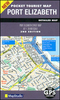
Port Elizabeth
Port Eizabeth at 1:25, 000 on a double-sided, indexed street plan from the South African publishers Map Studio, with coverage extending north of the city to include Despatch and Uitenhage. The plan highlights main traffic arteries including freeways and shows one way streets, traffic lights and locations of petrol stations.Colouring indicates parks and recreational areas, retail areas, informal settlements, etc, and symbols highlight numerous places of interest and facilities including cultural and educational establishments, municipal offices, and a variety of features such as hotels, tourist information offices, shopping centres, entertainment and sport facilities, public services, etc. The map has an extensive index and for GPS users latitude and longitude lines at
intervals of 30
intervals of 30
Product Description
Reviews/Comments
Add New
Vouchers
No voucher codes found.
Do you know a voucher code for this product or supplier? Add it to Insights for others to use.
Do you know a voucher code for this product or supplier? Add it to Insights for others to use.
 Denmark