More From Contributor
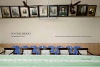
£8.99
This startling new book concentrates on the twenty years between 59 & 79AD, thus beginning with the earthquake which all but destroyed Pompeii & ending with the volcanic eruption which has become part of our collective popular imagination. Alex Butterworth & Ray Laurence have synthesised the latest research into Pompeii to bring this period of flux & instability back to life. By concentrating on key members from each strata of Pompeiian society we are plunged into the everyday life of a city rebuilding itself, in the knowledge that it will all be for nothing when Vesuvius erupts. So we follow Suedius Clemens who has been sent by Vespasian to settle disputes over land; Decimus Satrius Lucretius Valens who is set to join Pompeii`s elite magistrates following the death of his protector; the Vettii brothers who were fabulously rich & ostentacious dealers in wine & perfume; Pherusa, the runaway slave; lusty young Rustus who is contemplating parricide... ...
Archived Product
£9.95
Pomurje in a series of contoured, GPS compatible walking & cycling maps from Kartografija in Ljubljana, covering the whole of Slovenia at 1:75, 000. English language notes are on the reverse. The series also provides additional coverage of the Triglav National Park at 1:50, 000. The maps have contours at 20m intervals, enhanced by relief shading, with plenty of spot heights & names of peaks, mountain chains, etc. Local hiking routes are highlighted, indicating difficult passages. Also marked are recommended cycling routes. Symbols indicate various types of accommodation including mountain huts, campsites, inns with lodgings, tourist farms or apartments, hotels & motels, as well as recreational facilities (golf, horse riding, swimming pools, etc), vineries, cultural & historical sites, etc. Road network indicates locations of petrol stations. Railway lines are shown with stations & various types of mountain transport (gondolas, chair lifts, etc) are marked. The maps have a latitude & longitude grid at intervals of 2 ...
Archived Product
£14.99
Pomurje in a series of double-sided maps at 1:40, 000 from Kartografija in Ljubljana, accompanied by bilingual guides with descriptions of hiking trails, cycling routes, places of interest, lists of mountain huts, etc. The maps have contours at 20m intervals, enhanced by relief shading & graphics to provide a very effective picture of the topography. Waymarked hiking trails & cycling routes are prominently highlighted & cross-referenced to their descriptions in the accompanying guides. A wide range of symbols provide information on various types of accommodation (rural hotels, motels, farms, mountain huts, campsites), recreational facilities, picturesque locations, etc. For drivers, locations of petrol stations are marked. Each map is double-sided, with a good overlap between the sides, & has latitude & longitude lines at 2’ intervals. The accompanying pocket guides are bilingual, Slovenian/ English, with around 60 to 80 pages. Approx. half are descriptions of places of interest, illustrated by colour photos. Descriptions of hiking routes give timings & the degree of difficulty, as do notes for cycling routes which are also accompanied by route profiles. Also provided is a list of mountain huts. Map legends & all the text include English. ...
Archived Product
£6.99
Be prepared, whatever the weather, with these waterproof ponchos & handy pouch. Containing 2 rain ponchos & a drawstring pouch for convenient storage, this emergency rainwear will ensure you don`t get caught out. Compact, lightweight & featuring an integrated belt clip, the pouch attaches easily to any rucksack, bag or clothing. One size. ...
Archived Product
£3.50
Ponders End in 1895 in a fascinating series of reproductions of old Ordnance Survey plans in the Alan Godfrey Editions, ideal for anyone interested in the history of their neighbourhood or family. The map covers the Ponders End part of Enfield, from Churchbury station eastward to the Mare Dyke, & shows a semi-industrial area gathered around a few roads: Hertford Road running north-south, & The Ride, Nags Head Road & South Street running west-east. Features include Churchbury & Ponders End stations, the River Lea with Ponders End Lock, Corticine Works, White Lead Works, Flour Mill, nurseries, Durants Arbour, South Marsh. A directory is included on the reverse. About the Alan Godfrey Editions of the 25” OS Series: Selected towns in Great Britain & Ireland are covered by maps showing the extent of urban development in the last decades of the 19th & early 20th century. The plans have been taken from the Ordnance Survey mapping & reprinted at about 15 inches to one mile (1:4, 340). On the reverse most maps have historical notes & many also include extracts from contemporary directories. Most maps cover about one mile (1.6kms) north/south, one & a half miles (2.4kms) across; adjoining sheets can be combined to provide wider coverage.FOR MORE INFORMATION & A COMPLETE LIST OF ALL AVAILABLE TITLES PLEASE CLICK ON THE SERIES LINK. ...
Archived Product
£14.99
Here's the paradox: your body becomes steadily more troublesome just at that point when the world, which you are soon to leave, becomes sweeter, more poignant, more beautiful, more desirable... The ponds of Hampstead Heath are small oases; fragments of wild nature nestled in the heart of north-west London. For the best part of his life Al Alvarez
- poet, critic, novelist, rock-climber & poker player
- has swum in them almost daily. An athlete in his youth, Alvarez, now in his eighties, chronicles what it is to grow old with humour & fierce honesty
- from his relentlessly nagging ankle which makes daily life a struggle, to infuriating bureaucratic battles with the council to keep his disabled person's Blue Badge, the devastating effects of a stroke, & the salvation he finds in the three Ss
- Swimming, Sex & Sleep. As Alvarez swims in the ponds he considers how it feels when you begin to miss that person you used to be
- to miss yourself. Swimming is his own private form of protest against the onslaught of time; proof to others, & himself, that he's not yet beaten. By turns funny, poetic & indignant, Pondlife is a meditation on love, the importance of life's small pleasures &, above all, a lesson in not going gently in to that good night.


...
Archived Product
£9.99
The ponds of Hampstead Heath are small oases; fragments of wild nature nestled in the heart of north-west London. For the best part of his life Al Alvarez
- poet, critic, novelist, rock-climber & poker player
- has swum in them almost daily. An athlete in his youth, Alvarez, now in his eighties, chronicles what it is to grow old with humour & fierce honesty
- from his relentlessly nagging ankle which makes daily life a struggle, to infuriating bureaucratic battles with the council to keep his disabled person`s Blue Badge, the devastating effects of a stroke, & the salvation he finds in the three Ss
- Swimming, Sex & Sleep. As Alvarez swims in the ponds he considers how it feels when you begin to miss that person you used to be
- to miss yourself. Swimming is his own private form of protest against the onslaught of time; proof to others, & himself, that he`s not yet beaten. By turns funny, poetic & indignant, Pondlife is a meditation on love, the importance of life`s small pleasures &, above all, a lesson in not going gently in to that good night.


...
Archived Product
£6.95
Topographic coverage of mainland Spain at 1:50, 000 in the MTN50 (Mapa Topográfico Nacional) series from the Centro Nacional de Información Geografica, the country’s civilian survey organization. The maps have contours at 20m intervals, enhanced by relief shading, plus colouring and/or graphics to show different types of terrain, vegetation or land use. Boundaries of national parks & other protected areas are marked. In addition to all the usual information featured on topographic mapping at this scale, detailed presentation of the road & rail networks, rural tracks & paths, etc, the maps also show campsites & mountain refuges. On more recent editions some GRs, the official long-distance hiking routes, are also marked (although not as clearly as on hiking maps from other publishers). Each map covers 29.5x 18.5 km (with adjustments in the border or coastal areas). The maps have a 1-km UTM grid, plus margin ticks for latitude & longitude at 1` intervals. Map legend is in Spanish only.HOW TO CHOOSE THE RIGHT 50K MAP: all the titles in CNIG’s 200K Provincial Road Maps series at 1:200, 000 are overprinted with the grid for the 1:50, 000 maps & can be used to see the area covered by each 50K title. TO SEE THE LIST OF TITLES IN THIS SERIES PLEASE CLICK ON THE SERIES LINK.PLEASE NOTE
- MAP TITLES: the grids shown on our website serve both the civilian & the military 1:50, 000 topographic series. Although the areas covered by maps in both series are identical (apart from some border or coastal sheets), occasionally map titles differ – only one title is shown on the grid, usually the military one. In Galicia, the Basque country & in the Catalan speaking areas the tendency now is to use local place names rather than the often better known Castilian ones. Where possible, both versions are included in our titles. Map titles listed on our website are based on information received by us at the time of publication, but sometimes maps arrive showing a completely different title! As long as the map number is as ordered, the correct map has been supplied.
...
Archived Product
£6.50
Topographic coverage of mainland Spain at 1:25, 000 published by the Centro Nacional de Información Geograficá, the country’s civilian survey organization. The maps have contours at 10m intervals & colouring and/or graphics to show different types of vegetation or land use. Boundaries of national parks & other protected areas are marked. In addition to all the usual information shown on topographic maps at this scale, detailed presentation of the road & rail networks, rural tracks & paths, etc, the maps also show campsites. The maps have a 1-km UTM grid, with margin ticks for latitude & longitude at 1` intervals. Map legend is in Spanish only.PLEASE NOTE: our grid for the whole of Spain is in preparation
- in the meantime, for areas other than those shown on the attached grid please use CNIG’s topographic survey at 1:50, 000 by searching for ‘SI00000832’. Each 25K map covers one quarter of the corresponding 50K map, with the numbering system: I = NW quarter, II = NE quarter, III = SW quarter & IV = SE quarter. CNIG maps in the Provincial Road Maps series at 1:200, 000 are overprinted with the grid for the 1:50, 000 survey & can be used to see the area covered by each 50K or 25K title in more detail. To see the list of titles in this series please click on the series grid
- for map numbers not yet listed on our website please contact us by email.

...
Archived Product
£9.99
Pongau
- Hochkönig
- Saalfelden area of the Austrian Alps presented at 1:50, 000 in a series of contoured & GPS compatible

...
Archived Product

Pondicherry

A thoughtful photographic journey into the fascinating city of Pondicherry - the former French colony in India. Captures the essence of how the East meets the West today, in Pondicherry. Pondicherry is an extended photo essay, which has as its main focus, the photographer`s perception and visual interpretation of the city of Pondicherry. The photographer journeys into the metaphorical and anthropological folds of the city, searching for a sense of ”place” - his interpretation of a specific environment and how it`s inhabited. The photographer goes beyond the walls and penetrates into the private sphere, into homes, spaces and routines, which exemplify a certain culture or cultures, always searching for visual messages that compose the tapestry of perception, both of the past
and of the present. The perception of ”place” is also offered in words. The photographer has sought out the participation of several noted French and Indian writers, who have offered very personal and insightful views of Pondicherry - words and images working in a complimentary way for an artistic perception of Pondicherry.
RIP - This product is no longer available on our network. It was last seen on 25.09.2019

This page now acts as a permanent archive for this product. Add more information using the comments box below to ensure it can still be found by future generations.

Use our search facility to see if it is available from an alternative contributor.
  • External links may include paid for promotion
  • Availability: Out Of Stock
  • Supplier: Stanfords
  • SKU: 9788174368720
Availability: In Stock
£19.95

Product Description

A thoughtful photographic journey into the fascinating city of Pondicherry
- the former French colony in India. Captures the essence of how the East meets the West today, in Pondicherry. Pondicherry is an extended photo essay, which has as its main focus, the photographer`s perception & visual interpretation of the city of Pondicherry. The photographer journeys into the metaphorical & anthropological folds of the city, searching for a sense of ”place”
- his interpretation of a specific environment & how it`s inhabited. The photographer goes beyond the walls & penetrates into the private sphere, into homes, spaces & routines, which exemplify a certain culture or cultures, always searching for visual messages that compose the tapestry of perception, both of the past & of the present. The perception of ”place” is also offered in words. The photographer has sought out the participation of several noted French & Indian writers, who have offered very personal & insightful views of Pondicherry
- words & images working in a complimentary way for an artistic perception of Pondicherry.

Reviews/Comments

Add New

Intelligent Comparison

Oooops!
We couldn't find anything!
Perhaps this product's unique.... Or perhaps we are still looking for comparisons!
Click to bump this page and we'll hurry up.

Price History

Vouchers

No voucher codes found.
Do you know a voucher code for this product or supplier? Add it to Insights for others to use.

Facebook

Jargon Buster

India - A subcontinent in Asia
Thoughtful - When someone is thinking and absorbed in what they are thinking
Personal - Something that belongs more to an individual due to it affecting them more by relating to them.
Environment - The conditions and surrounding area.

Supplier Information

Stanfords
Stanfords was established in 1853 and opened their iconic Covent Garden flagship store in 1901. They have become the top retailer of maps, travel books and accessories in the UK and arguably offer the largest selection of maps and travel books worldwide. Famous names such as Captain Robert Falcon Scott, Ranulph Fiennes and Michael Palin have purchased from Stanfords. They now have a shop in Bristol and both stores together with other venues operate a calendar of events including talks, book signings and exhibitions. As a specialist map retailer, the map selection is comprehensive and includes road maps, street maps and walking maps from worldwide destinations, as well as a selection of world atlases and wall maps. Books include travel guides and travel literature. Stanfords also stock globes, from miniatures made of blue marble to magnificent floor-standing globes. The website features a selection of interesting articles on travel topics.
Page Updated: 2023-11-12 20:15:36

Community Generated Product Tags

Oh No! The productWIKI community hasn't generated any tags for this product yet!
Menu