More From Contributor
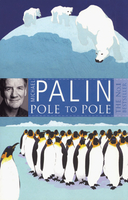
£25.00
Paul Nicklen`s bold expeditions take him underwater to deliver close-up, first-ever documentation of the lives of leopard seals, whales, walruses, polar bears, bearded seals, & narwhals. & he travels over the ice to look at muskoxen, grizzly bears, caribou, foxes, wolves, & much more. Scenes are bathed in polar light, surreal & breathtakingly beautiful. National Geographic is providing unprecedented support to Nicklen both because of his remarkable photographic achievement & because of his contribution to studies on animal behavior & global climate change so consequential today. Nicklin is an emerging star. His inspiring & amazing work offers unprecedented insights into animal behavior & breaks new ground in photography. ...
Archived Product
£3.99
Maps from British Antarctic Survey’s catalogue which are likely to appeal to a wider audience, including the growing number of visitors to the Antarctic or South Georgia, collectors seeking examples of beautifully presented topographic mapping, etc.PLEASE NOTE: a separate series on our website presents BAS titles which are of interest mainly to scientific experts or academic staff: larger scale topographic or geological/earth sciences maps of sections of the Antarctic & maps accompanied by detailed booklets/monographs. ...
Archived Product
£69.00
Operating ships within any ice regime requires knowledge, skills & awareness beyond those possessed by most mariners. Written by a respected Arctic shipping expert with extensive operational experience, this book provides practical advice on conditions, awareness & preparations for transits in polar waters. Since the first edition was published in 2012, sea ice loss in the Arctic has accelerated dramatically & more, but less experienced, ship operators are becoming active in the area. This edition takes account of IMO’s Polar Code, which entered into force on 1 January 2017, & also Arctic Council agreements on SAR & marine pollution. Polar Ship Operations is an indispensable companion for any mariner contemplating sailing in ice-affected waters. ...
Archived Product
£12.99
Polar explorers were the superstars of the ”heroic age” of exploration, a period spanning the Victorian & Edwardian eras. In this engaging book, author Kari Herbert explores the unpredictable, often heartbreaking lives of seven remarkable women who married world-famous polar explorers.
As the daughter of a pioneering polar explorer, Herbert brings a unique perspective to these stories of polar exploration. In her portraits of the gifted sculptor Kathleen Scott; eccentric traveller Jane Franklin; spirited poet Eleanor Anne Franklin; Jo Peary, the first white woman to travel & give birth in the High Arctic; talented & determined Emily Shackleton; Norwegian singer Eva Nansen; & her own mother, adventurer Marie Herbert, Karie Herbert blends deeply personal accounts of longing, betrayal, & hope with stories of peril & adventure.
Herbert illuminates the essential role the women played in supporting, publicizing, defending, & even financing their husbands` expeditions. She follows these ”polar wives” not only to the polar wastelands but through war-torn Macedonia, the lawless outback of Australia, & the plague--riddled ancient cities of the Holy L&.
With extracts from previously unpublished historic journals & letters, ” Polar Wives” brings together for the first time, the compelling stories of seven adventurous women


...
Archived Product
£16.99
The Arctic & Antarctic are two of the greatest deserts on earth, the least known & most vital to our survival, but polar opposites in more than geography. The High Arctic is a sea surrounded by l&, Antarctica a mountainous continent surrounded by ocean. The Arctic sustains a large indigenous population; nobody but scientists with long supply lines can survive in Antarctica. Politically, the Arctic rim is controlled by the nations that surround it; Antarctica is neutral demilitarized territory supervised by an international treaty. Between them, the polar regions act as the world's refrigerator, helping to drive the world's weather systems. Both contain clues to the origins & potential fate of the planet, & each contains riches for the meteorologist & geologist, the biologist & paleontologist
- while offering temptations to the military strategist & the minor speculator who have already been at work in the north. Writer & broadcaster Daniel Snowman has made a number of journeys to both polar regions. His visits around the circumpolar North have included journeys in the high Arctic by dog-sled, skidoo & dinghy as well as trips through the heart of the heavily militarized north Russia coastline & to the oil-rich North Slope of Alaska. He has also made voyages down to both East & West Antarctica & met those at the forefront of the debate about such issues as ozone depletion & global warming. His book aims to combine science with social, economic & political analysis. It is tries to reveal something of the excitement of life at the ends of the earth
- with concern for the issues that humanity may have to address.

...
Archived Product
£6.99
Everybody knows that penguins belong at the South Pole & polar bears live at the North Pole
- but what would happen if, one day,
...
Archived Product
£13.99
Polhograjsko Hribovje area at 1:25, 000 in a series of contoured, GPS compatible recreational maps from Planinska zveza Slovenie
-
...
Archived Product
£7.99
The police urgently need Harry Hole. A killer is stalking Oslo`s streets. Police officers are being slain at the scenes of crimes they once investigated, but failed to solve. The murders are brutal, the media reaction hysterical. But this time, Harry can`t help anyone. For years, detective Harry Hole has been at the centre of every major criminal investigation in Oslo. His dedication to his job & his brilliant insights have saved the lives of countless people. But now, with those he loves most facing terrible danger, Harry can`t protect anyone. Least of all himself. ...
Archived Product
£6.95
Topographic coverage of mainland Spain at 1:50, 000 in the MTN50 (Mapa Topográfico Nacional) series from the Centro Nacional de Información Geografica, the country’s civilian survey organization. The maps have contours at 20m intervals, enhanced by relief shading, plus colouring and/or graphics to show different types of terrain, vegetation or land use. Boundaries of national parks & other protected areas are marked. In addition to all the usual information featured on topographic mapping at this scale, detailed presentation of the road & rail networks, rural tracks & paths, etc, the maps also show campsites & mountain refuges. On more recent editions some GRs, the official long-distance hiking routes, are also marked (although not as clearly as on hiking maps from other publishers). Each map covers 29.5x 18.5 km (with adjustments in the border or coastal areas). The maps have a 1-km UTM grid, plus margin ticks for latitude & longitude at 1` intervals. Map legend is in Spanish only.HOW TO CHOOSE THE RIGHT 50K MAP: all the titles in CNIG’s 200K Provincial Road Maps series at 1:200, 000 are overprinted with the grid for the 1:50, 000 maps & can be used to see the area covered by each 50K title. TO SEE THE LIST OF TITLES IN THIS SERIES PLEASE CLICK ON THE SERIES LINK.PLEASE NOTE
- MAP TITLES: the grids shown on our website serve both the civilian & the military 1:50, 000 topographic series. Although the areas covered by maps in both series are identical (apart from some border or coastal sheets), occasionally map titles differ – only one title is shown on the grid, usually the military one. In Galicia, the Basque country & in the Catalan speaking areas the tendency now is to use local place names rather than the often better known Castilian ones. Where possible, both versions are included in our titles. Map titles listed on our website are based on information received by us at the time of publication, but sometimes maps arrive showing a completely different title! As long as the map number is as ordered, the correct map has been supplied.
...
Archived Product
£11.50
Topographic survey of France at 1:25, 000 in IGN`s excellent TOP25 / Série Bleue series. All the maps are GPS compatible, with a 1km UTM grid plus latitude & longitude lines at 5’ intervals. Contours are at 5m intervals except for mountainous areas where the maps have contours at 10m intervals, vividly enhanced by hill shading & graphics for rocky terrain. Colouring with graphics indicates different types of vegetation or land use (deciduous or coniferous forests, moors, orchards, vineyards, etc). PLEASE NOTE: coverage of France at this scale is currently being revised – the format & the presentation of each title are indicated by the letters at the end of its Sheet Reference number (e.g. 0416ET, 3531ETR, 1923SB, etc.)MAPS WITH FULL TOURIST OVERPRINT & AN ENGLISH MAP LEGEND: all TOP25 maps & the SB editions of Série Bleue have an overprint highlighting waymarked walking trails including long-distance GR routes &, where appropriate, ski routes. Symbols indicate campsites, gîtes d’etape, refuges, equestrian centres & other recreational facilities or sites, tourist information centres, cultural heritage, etc. Towns & locations of particular interest are highlighted.- ET or OT = single-sided TOP25 map covering approx. 29x 21 km / 18x 13 miles.- ETR or OTR = waterproof & tear resistant TOP25 map covering the same area as the corresponding ET or OT number, but double-sided, printed on a smaller size sheet with a good overlap between the sides.- SB = Série Bleue map with full tourist overprint; these maps, first introduced in summer 2014, each cover approx. 29x 24km / 18x 15 miles.SÉRIE BLEUE maps with numbers ending in E (Est) or O (Ouest): most editions now indicate the GR routes, but do not show any other tourist information. Map legend is in French only. Each map covers approx. 14x 20km / 9x 12 miles. ...
Archived Product

Pole To Pole

Michael Palin travels Pole to Pole - from the North Pole as due south as geographically and politically possible to the South Pole: from the cold grip of the Arctic Circle and its polar bears to midnight sun and penguins whilst following in the footsteps of Captain Scott.A lot of land and sea sits between the poles and Palin journeys by train, truck, raft, ski-doo, barge, balloon and bicycle to cross it all. Along the way he comes across Garibaldi biscuits in Ethiopia, meets countless friendly locals, endures an unruly digestive system and is halted by the unfriendly gunfire and battles that are unfurling in the world around him as he travels.
RIP - This product is no longer available on our network. It was last seen on 25.09.2019

This page now acts as a permanent archive for this product. Add more information using the comments box below to ensure it can still be found by future generations.

Use our search facility to see if it is available from an alternative contributor.
  • External links may include paid for promotion
  • Availability: Out Of Stock
  • Supplier: Stanfords
  • SKU: 9780753823262
Availability: In Stock
£8.99

Product Description

Michael Palin travels Pole to Pole
- from the North Pole as due south as geographically & politically possible to the South Pole: from the cold grip of the Arctic Circle & its polar bears to midnight sun & penguins whilst following in the footsteps of Captain Scott.A lot of land & sea sits between the poles & Palin journeys by train, truck, raft, ski-doo, barge, balloon & bicycle to cross it all. Along the way he comes across Garibaldi biscuits in Ethiopia, meets countless friendly locals, endures an unruly digestive system & is halted by the unfriendly gunfire & battles that are unfurling in the world around him as he travels.

Reviews/Comments

Add New

Intelligent Comparison

Oooops!
We couldn't find anything!
Perhaps this product's unique.... Or perhaps we are still looking for comparisons!
Click to bump this page and we'll hurry up.

Price History

Vouchers

No voucher codes found.
Do you know a voucher code for this product or supplier? Add it to Insights for others to use.

Facebook

Jargon Buster

Balloon - A inflatable bag filled with a type of gas commonly helium, hydrogen or air
sun - A star at the centre of the solar system.
World - A physical grouping, commonly used to describe earth and everything associated with ti

Supplier Information

Stanfords
Stanfords was established in 1853 and opened their iconic Covent Garden flagship store in 1901. They have become the top retailer of maps, travel books and accessories in the UK and arguably offer the largest selection of maps and travel books worldwide. Famous names such as Captain Robert Falcon Scott, Ranulph Fiennes and Michael Palin have purchased from Stanfords. They now have a shop in Bristol and both stores together with other venues operate a calendar of events including talks, book signings and exhibitions. As a specialist map retailer, the map selection is comprehensive and includes road maps, street maps and walking maps from worldwide destinations, as well as a selection of world atlases and wall maps. Books include travel guides and travel literature. Stanfords also stock globes, from miniatures made of blue marble to magnificent floor-standing globes. The website features a selection of interesting articles on travel topics.
Page Updated: 2023-11-12 20:15:36

Community Generated Product Tags

Oh No! The productWIKI community hasn't generated any tags for this product yet!
Menu