
 United Kingdom
 France
 Germany
 Netherlands
 Sweden
 USA
USA
 Italy
Italy
 Spain
Spain
More From Contributor


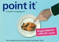
Point It - Traveller`s Language Kit
Be understood anywhere with this practical pocket size traveller’s language kit. Point It is a little 72 pages booklet containing over 1, 300 pictures of anything you will ever need to ask. Find the picture for what you want to say, from food and transport to shopping and leisure. This compact booklet also features a small reference world map and a small printed ruler. Whether you are heading around the world or to a remote destination, don’t forget this lifesaver. If you can’t say it, point it!

Product Description
Reviews/Comments
Add New
Vouchers
No voucher codes found.
Do you know a voucher code for this product or supplier? Add it to Insights for others to use.
Do you know a voucher code for this product or supplier? Add it to Insights for others to use.
 Denmark