More From Contributor

£9.99
The five mountain chains of the Carpathian Bend in Romania: Piatra Craiului, Bucegi, Postavarul, Piatra Mare & Ciucas at 1:70, 000 in a series of detailed contoured maps covering popular hiking areas of Transylvania published by Dimap, one of Hungary’s leading publishers specializing in mapping of that region. The map has contours at 100m intervals enhanced by relief shading. Several trails are marked, with symbols distinguishing between well & poorly signposted sections. Forested areas & nature reserves are marked & symbols show local caves & springs, accommodation (hotels, campsites & refuges) skiing areas & ski-lifts, various places of interest including churches & monasteries, etc. The map has a latitude & longitude grid at 2’ intervals. An inset shows the area of the map at 1:350, 000 with bold altitude colouring to provide a more vivid impression of local topography, main roads, & rail connections with Brasov. On the reverse are black & white street plans of Brasov & Sinaia, plus notes describing the region & the tourist paths identified on the map. Map legend & all the notes include English. To see all the titles in this series of hiking maps of Romania please click on the series link. ...
Archived Product
£5.00
Piatra Craiului Mountains at 1:30, 000 on a contoured map highlighting hiking routes. Topography is shown by contours at 50m intervals with additional relief shading & colouring for woodlands. An overprint highlights hiking routes, indicating their waymarking signs. Also marked are mountain huts & refuges. The map has no geographical coordinates. Map legend

Includes::
English. On the reverse are notes on the area, lists of chalets & refuges, plus detailed descriptions of 26 routes
- all the text

Includes::
English.


...
Archived Product
£6.00
Piatra Craiului Mountains at 1:30, 000 on a contoured map highlighting hiking routes. Topography is shown by contours at 50m intervals with additional relief shading & colouring for woodlands. An overprint highlights hiking routes, indicating their waymarking signs. Also marked are mountain huts & refuges. The map has no geographical coordinates. Map legend

Includes::
English. On the reverse are notes on the area, lists of chalets & refuges, plus detailed descriptions of 26 routes
- all the text

Includes::
English.


...
Archived Product
£8.99
The Piazza San Marco is the most famous townscape in the West. This book is the first to consider it as a coherent whole, as a theatre in which the whole of Venetian history took place, to which it can serve as a highly evocative introduction. Piazza San Marco is a dynamic open space organically connected to the buildings which frame it. It shows how much is lost if the ensemble is divided into the individual structures of Doges` Palace, Basilica of San Marco, Campanile & so on, each `marvellous` in their own right but functionally separate. Here a different story is told by relating them to each other & to the theatrical piazza of which they form a part; it sees the events that took place there as a barometer of 1, 000 years of Venetian history. It recreates not only rituals of the past but also the activities of the present
- from the coronation of the Doge & the arrival of the Crusaders` loot, through the pathetic collapse of the Republic, to Death in Venice & the legendary Pink Floyd concert of 1989
- all taking place in an iconic space which the writings of traditional historians have left dead & silent.

...
Archived Product
£22.99
The best rides in the freeride hot spots of the Alps – this is the simple formula of the Freeride Maps. The first map available to freeriders is making the locals freeride knowledge available to a broad public. All ridable slopes, drops & couloirs are marked as freeride corridors in different colours for three difficulty ratings: blue for technically easy terrain, yellow requires advanced to very advanced ability & red is extremely difficult terrain that is partially exposed & therefore reserved to crack riders. Short ascents are marked with red lines. The Freeride Maps are based on topographic maps 1:25, 000. They contain all essential information about the terrain that is necessary for planning & going freeriding. The maps are printed on water resistant & indestructible paper. On the back side, the maps include all relevant planning, safety & rescue information. ...
Archived Product
£14.99
Pica d` Estats
- Mont-roig area of the Catalan Pyrenees just west of Andorra on a contoured & GPS-compatible map at 1:25, 000
...
Archived Product
£20.99
Picardie in a series of guides to France’s navigable rivers & canals from Editions du Breil, providing mapping of the waterways with better presentation of the surrounding countryside, including street plans of main towns along the routes. Coverage

Includes::
Oise, Canal latéral à l’ Oise, Canal de Saint-Quentin, Escaut canalise, Escaut, grand gabarit, Aisne, Canal lateral à l’ Aisne, Canal de l’ Oise à l’ Aisne, Canal du Nord, Canal de la Sensée & Somme. The maps present the waterways with locks, mooring places, etc. & the surrounding localities annotated with symbols indicating various facilities & places of interest. Most map panels cover a full page, enabling the publishers to provide better coverage of the surrounding countryside, showing more local towns & villages plus the connecting roads. The guides also include better street plans of selected larger towns, indicating main sights, etc. Navigating instructions or tips & information about various facilities or places of interest are usually located on a page opposite to the map of the route. The guides also contain general information on rules & regulations for navigating along France’s inland waterways, plus examples of signs & signals. All of the text, explanations & the map legend are in French, English & German. To see the list of other titles in this series please click on the series link.

...
Archived Product
£15.99
Picardie
- Baie de Somme Guide Vert *FRENCH Edition* in Michelin’s Green Guide series covering France, with all the regions available
...
Archived Product
£30.00
Picardy in a series of guides from Editions Grafocarte/ Editions de l` Ecluse to France’s canals & navigable waterways with mapping showing facilities & navigational hazards along each route, general information on signals & regulations, & descriptions of places of interest Each guide provides mapping of the route showing locks, stop gates, mooring quays, tunnels, weirs, dangerous shoals, sand or mud banks, etc., as well as a wide range of facilities from drinking water & rubbish disposal to various types of shops, restaurants, pharmacies, shipyards & engine repair workshops, etc. The mapping is usually presented as vertical 28 x 8.5cm panels which, together with the annotations, occupy one whole page of the guide & so each cover 14km or more of the route. Also included as necessary are more detailed enlargements of main basins or photographs of bridges, shown usually as viewed from both directions. The text providing navigational information & tips as well as descriptions of places of interest & a general background are kept separate from the maps but, where possible, placed on the adjoining page to the relevant section of the route. The guides also provide general information on rules & regulations, plus illustrations of navigational signals. Each guide also has an index of locations along the route annotated with symbols indicating various facilities, accompanied where possible with contact details.* All of the text, explanations & the map legend are in French, English & German.** Please note:** The publishers’ name has changed from Editions Grafocarte to Editions de l’ Ecluse & the series name shown on each title is Fluviacarte of Navicarte depending on whether mapping of coastal waters is included. Various combinations of these names can be found"ed in other publications on French waterways. ...
Archived Product
£3.50
Piccadilly area of London in 1869 in a series of exceptionally detailed reproductions of old Ordnance Survey street plans for areas of larger cities which have undergone substantial redevelopment in the late 19th or the early 20th century, published in the Alan Godfrey Editions. The plans, printed in back & white, have been taken from the original Ordnance Survey mapping at 1:1, 056 & reproduced at 1:1, 760 – the equivalent of 36 inches (or one yard) to a mile. The maps provide an unrivalled, house-by-house picture of streets & individual buildings with inner courtyards, outbuildings, pavements, covered passages, etc. Many important institutions are named; within the National Galley on Trafalgar Square even the individual rooms (the map is from 1871, so no French Impressionists as yet!). On the reverse are historical notes about the area covered by the map, plus extracts from contemporary street directories. These maps provide a fascinating addition to Alan Godfrey’s huge series of some 2, 000 titles presenting reproductions of street plans at taken from the Ordnance Survey mapping at 1:2, 500 (25” to 1 mile) & reprinted at about 15 inches to one mile (1:4, 340). ...
Archived Product

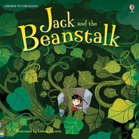
Pic Jack & The Beanstalk

Jack and his mother are so poor that they don`t have anything to eat. Their hope is fading, until Jack meets a strange little man with a handful of magic beans. But what will be the price that Jack must pay? This classic fairytale is retold for young children and illustrated throughout with the bright artwork of Lorena Alvarez.
RIP - This product is no longer available on our network. It was last seen on 25.09.2019

This page now acts as a permanent archive for this product. Add more information using the comments box below to ensure it can still be found by future generations.

Use our search facility to see if it is available from an alternative contributor.
  • External links may include paid for promotion
  • Availability: Out Of Stock
  • Supplier: Stanfords
  • SKU: 9781409593485
Availability: In Stock
£4.99

Product Description

Jack & his mother are so poor that they don`t have anything to eat. Their hope is fading, until Jack meets a strange little man with a handful of magic beans. But what will be the price that Jack must pay? This classic fairytale is retold for young children & illustrated throughout with the bright artwork of Lorena Alvarez.

Reviews/Comments

Add New

Intelligent Comparison

Oooops!
We couldn't find anything!
Perhaps this product's unique.... Or perhaps we are still looking for comparisons!
Click to bump this page and we'll hurry up.

Price History

Vouchers

No voucher codes found.
Do you know a voucher code for this product or supplier? Add it to Insights for others to use.

Facebook

Jargon Buster

Classic - Something that is still like it was originally a high quality standard.
Children - A young life form within the early stages of physical development,

Supplier Information

Stanfords
Stanfords was established in 1853 and opened their iconic Covent Garden flagship store in 1901. They have become the top retailer of maps, travel books and accessories in the UK and arguably offer the largest selection of maps and travel books worldwide. Famous names such as Captain Robert Falcon Scott, Ranulph Fiennes and Michael Palin have purchased from Stanfords. They now have a shop in Bristol and both stores together with other venues operate a calendar of events including talks, book signings and exhibitions. As a specialist map retailer, the map selection is comprehensive and includes road maps, street maps and walking maps from worldwide destinations, as well as a selection of world atlases and wall maps. Books include travel guides and travel literature. Stanfords also stock globes, from miniatures made of blue marble to magnificent floor-standing globes. The website features a selection of interesting articles on travel topics.
Page Updated: 2023-11-12 20:15:36

Community Generated Product Tags

Oh No! The productWIKI community hasn't generated any tags for this product yet!
Menu