
 United Kingdom
 France
 Germany
 Netherlands
 Sweden
 USA
USA
 Italy
Italy
 Spain
Spain
More From Contributor


Pets
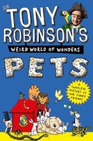
In Sir Tony Robinson`s Weird World of Wonders: Pets, Sir Tony Robinson takes you on a headlong gallop through time, pointing out all the most important, funny, strange, amazing, entertaining and smelly bits about pets. It`s history, but not as we know it!Find out everything you ever needed to know about pets through time in this brilliant illustrated, action-packed, fact-filled book, including:- The fact that Egyptians worshipped cats and shaved off their eyebrows to mourn them when they died- The brilliant and extremely useful jobs that animals did and still do for us in times of war- A whole array of bizarre animals through time, including medieval squirrels!- Pet fashions and fashionable petsAnd lots of other facts about the amazing pets that we spend our lives with.What are
you waiting for? Let`s get going... For more funny history facts discover the whole series!
you waiting for? Let`s get going... For more funny history facts discover the whole series!

Product Description
Reviews/Comments
Add New
Vouchers
No voucher codes found.
Do you know a voucher code for this product or supplier? Add it to Insights for others to use.
Do you know a voucher code for this product or supplier? Add it to Insights for others to use.
 Denmark