More From Contributor

£15.99
Peru in the Countries, Regions & Cities series from Rough Guides; comprehensively detailed guidebooks specifically designed for independent travellers & serving a range of worldwide destinations. Widely recognised for their free editorial style, Rough Guide authors are allowed to express their personal opinions on a range of subjects. Although sometimes controversial, this editorial stance allows readers to experience more detailed & personal takes on each destination, a feature often more limited in other guidebooks. Cultural & historical nuances are explored in significant depth throughout the text & descriptions on the ambience of individual settings alongside personal recommendations, particularly in cities, are notably prevalent. Each Rough Guide in the Countries, Regions & Cities series has a similar layout. A ...
Archived Product
£9.95
From the awe-inspiring ruins of Machu Picchu to the bustling metropolis of Cuzco--the country's capital--from dense subequatorial rainforests to the snowy peaks of the Andes Mountains, this volume transports readers to a land with a tumultuous history & deeply rooted spiritual legacy. Armchair travelers explore ancient archaeological sites deep in the jungle, travel on the highest railway line in the world, & admire the meticulous construction of mysterious cities built of stone. With its accessible text & vibrant photographs, this book provides an excellent introduction to the fascinating country of Peru.

...
Archived Product
£9.50
Peru at 1:1, 500, 000 on an indexed, waterproof & tear-resistant road map with topographic & tourist information, published by Reise Know-How as part of their highly acclaimed World Mapping Project. The map is double-sided to provide the best balance between a good scale & a convenient size sheet. Coverage extends north to Quito. The country ...
Archived Product
£17.50
Writing from New York in March 1949, Robert Frank sent home to his mother in Switzerland a birthday gift of a book maquette of a series of photographs he had made during a visit to Peru. Frank made an identical book for himself & one of each of these two dummies now resides in the collections of the Museum of Modern Art, New York, & National Gallery of Art, Washington. A few of these images are well-known in Franks oeuvre but previously the entire series had only ever been seen by a small number of people. This book presents for the first time the complete sequence of images, based on the original book Frank had conceived & realised under his direction. ” Peru” is a work of major historical significance in both the artists history & the history of photography. ...
Archived Product
£10.99
Peru at 1:1, 500, 000 on an indexed double-sided map from Mapas Na Turismo with very clear presentation of the country’s topography through relief based on satellite imagery, subtle altitude colouring & plenty of stop heights. The map divides the country north/south across the Cordillera Blanca, with Huaraz shown on both sides. Coverage on the northern side extends well beyond Ambato in Ecuador to include at the map edge both Cotopaxi & Sincholagua. The southern half

Includes::
La Paz & Cordillera Real in Bolivia. Excellent use of relief shading & altitude colouring gives an almost 3-D presentation of the terrain. National parks & other protected areas are clearly marked. Additional graphics indicate swamps & salt pans. Road network

Includes::
seasonal tracks & indicates driving distances on main routes. Railway lines are included & domestic airports are marked. Symbols highlight various places of interest including UNESCO World Heritage sites, hiking areas, locations for observing local fauna, etc. Latitude & longitude lines are drawn at 1° intervals. The map is indexed & its legend

Includes::
English.


...
Archived Product
£15.99
Peru in the Countries & Regions series from Lonely Planet, market-leading comprehensive guides aimed at independent travellers & serving a large range of international destinations. Frank & informal in style, the guides explore an extensive range of sights, activities, accommodation, restaurants & nightlife & are designed for practical use while travelling on the road. Written & researched by a team of experts, each book is independent in its recommendations & suggestions, often offering individual takes on individual destinations. Widely recognised for their reliability, each Lonely Planet country & region guide has the same layout. Introductory sections profile the destination with individual chapters on particular highlights, getting started, (including when to go) itineraries, history, culture, arts, food & drink & the environment. Each guide is organised geographically by region, with individual sections detailing an extensive range of sights, places of interest, attractions, restaurants, nightlife, accommodation & any local activities. The guides have detailed explanations of historical context where relevant. There is also practical guidance on ...
Archived Product
£6.95
Puru in the Culture Smart range of pocket-sized guide books; providing detailed information on local customs, culture, etiquette & manners & ensuring that visitors are prepared for a diverse range of social environments. The series covers an extensive number of countries worldwide & are designed both for those working & living abroad, as well as for visitors who do not want to offend, either intentionally or inadvertently. Their aim is to prevent readers from making embarrassing mistakes & feel confident in unfamiliar situations, while preparing them before arrival on what to expect & how to behave. Each guide is arranged thematically, with dedicated individual chapters on land & people, values & attitudes, customs & traditions, making friends, people at home, ...
Archived Product
£6.95
Peru in the Culture Smart range of pocket-sized guide books; providing detailed information on local customs, culture, etiquette & manners & ensuring that visitors are prepared for a diverse range of social environments. The series covers an extensive number of countries worldwide & are designed both for those working & living abroad, as well as for visitors who do not want to offend, either intentionally or inadvertently. Their aim is to prevent readers from making embarrassing mistakes & feel confident in unfamiliar situations, while preparing them before arrival on what to expect & how to behave. Each guide is arranged thematically, with dedicated individual chapters on land & people, values & attitudes, customs & traditions, making friends, people at home, ‘time-out’, travelling & communicating. There is also a separate chapter for business travelers, with important information on subjects such as business culture, meetings & making appointments. A Further Reading section also offers a list of recommended other history, travel literature & language titles available on the country. ...
Archived Product
£10.99
Peru & Ecuador at 1:2, 500, 000 from Nelles Verlag, with a smaller size sheet offering a convenient format for use when travelling. Included are several street plans of main cities, plus enlargements of popular areas of Peru. The map is double-sided, showing Ecuador with the northern & the Amazonian part of Peru on one side; on the reverse is central & southern Peru plus the adjoining parts of Bolivia with La Paz & Cordillera Real. Vivid relief shading, numerous spot heights & names of mountain ranges present the topography. National parks & other protected area are marked. Road network distinguishes between highways in good & poor condition &

Includes::
partially paved roads & cart tracks, with distances shown on main routes. Railway lines & local airports are included, & the map also shows internal administrative boundaries with names of the provinces. Numerous places of interest are prominently marked. Latitude & longitude margin ticks are at 2° intervals. The map has no index of localities. Map legend

Includes::
English. Street plans highlighting main places of interest, selected accommodation, etc, cover central areas of Quito (with an enlargement for the Old Town), Guayaquil, Cuenca & Otavalo in Ecuador. For Peru the map provides street plans of central Lima, Cusco, Arequipa, Ayacucho & Trujillo, enlargements showing the Cusco
- Machu Picchu area, the Inca Trail, the Cashapampa
- Llanganuco & the Olleros
- Chavín treks in Cordillera Blanca, plus the Cordillera Huyahuash circuit. Also provided is a map of the Nasca Lines.


...
Archived Product
£7.99
Peru was once the center of an extensive South American empire ruled by the Inca. Rich archaeological sites dating to the time of the Inca draw tourists & scientists alike to the region. Features of the series include: main chapters that focus on geography, people & culture, history, government & economy, & nature; ' At a Glance' double spreads to present a maximum amount of information in a minimal amount of space, utilizing charts, tables, time lines, & other highly visual elements; &, full-page maps that highlight physical features, vegetation & ecosystems, history, population, & political organization. As a bonus, every photograph within each chapter is tied to a location on the main map for that chapter. Smaller maps zoom in on special topics, such as migration, rainfall, changing borders, resources, industry, & other important themes. This book
Includes:: special feature sidebars that introduce intriguing people, places, & events; a glossary to aid in comprehension of unfamiliar terms; &, an extensive bibliography that lists books, National Geographic articles, & Web sites.
...
Archived Product

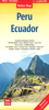
Peru (ed. 6) SUPERCEDED

This title contains strong activities focus, including surfing off the North Coast and hiking in the Cordillera Blanc and Cordillera Huayhuash. It contains a special section on the Incan World. It includes insightful history and culture chapters. It provides excellent coverage of Machu Picchu and spectacular lesser known archaeological sites. It features an increased extent by 132 pages and 8 maps to cover more off-the-beaten track destinations. It also contains discerning hotel and restaurant reviews reflect the best choices available.
RIP - This product is no longer available on our network. It was last seen on 25.09.2019

This page now acts as a permanent archive for this product. Add more information using the comments box below to ensure it can still be found by future generations.

Use our search facility to see if it is available from an alternative contributor.
  • External links may include paid for promotion
  • Availability: Out Of Stock
  • Supplier: Stanfords
  • SKU: 9781740597494
Availability: In Stock
£14.99

Product Description

This title contains strong activities focus, including surfing off the North Coast & hiking in the Cordillera Blanc & Cordillera Huayhuash. It contains a special section on the Incan World. It

Includes::
insightful history & culture chapters. It provides excellent coverage of Machu Picchu & spectacular lesser known archaeological sites. It features an increased extent by 132 pages & 8 maps to cover more off-the-beaten track destinations. It also contains discerning hotel & restaurant reviews reflect the best choices available.

Reviews/Comments

Add New

Intelligent Comparison

Oooops!
We couldn't find anything!
Perhaps this product's unique.... Or perhaps we are still looking for comparisons!
Click to bump this page and we'll hurry up.

Price History

Vouchers

No voucher codes found.
Do you know a voucher code for this product or supplier? Add it to Insights for others to use.

Facebook

Jargon Buster

Hiking - An outdoor activity envolving walking in nature
Hotel - An establishment which provides lodging for a fee
strong - A descriptive word for an item that has physical strength
History - Anything that happens in the past. An acedemic subject.
World - A physical grouping, commonly used to describe earth and everything associated with ti
Spectacular - Something that catches that eye due to its eye catchingness.

Supplier Information

Stanfords
Stanfords was established in 1853 and opened their iconic Covent Garden flagship store in 1901. They have become the top retailer of maps, travel books and accessories in the UK and arguably offer the largest selection of maps and travel books worldwide. Famous names such as Captain Robert Falcon Scott, Ranulph Fiennes and Michael Palin have purchased from Stanfords. They now have a shop in Bristol and both stores together with other venues operate a calendar of events including talks, book signings and exhibitions. As a specialist map retailer, the map selection is comprehensive and includes road maps, street maps and walking maps from worldwide destinations, as well as a selection of world atlases and wall maps. Books include travel guides and travel literature. Stanfords also stock globes, from miniatures made of blue marble to magnificent floor-standing globes. The website features a selection of interesting articles on travel topics.
Page Updated: 2023-11-12 20:15:36

Community Generated Product Tags

Oh No! The productWIKI community hasn't generated any tags for this product yet!
Menu