More From Contributor
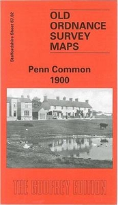
£7.99
Peninsular Malaysia at 1:1, 000, 000 on a double-sided map from Periplus, with large street plans central Kuala Lumpur, Melaka & Johor Bahru, plus enlargements of the Greater KL & the Singapore/ Johor Bahru areas, Penang & Langkawi. Peninsular Malaysia is shown on one side of the map at 1:1, 000, 000. The network of main & selected local roads & railways is presented on a base with bold relief shading/colouring & spot heights for the main peaks. Local airports are marked & main places of interest highlighted, such as historic sites, beach resorts, diving sites & national parks. The mapping also shows internal administrative divisions with names of the provinces. Latitude & longitude lines are drawn at intervals of 1 ...
Archived Product
£6.99
Peninsular Malaysia at 1:1, 000, 000 on a double-sided map from Periplus, with large street plans central Kuala Lumpur, Melaka & Johor Bahru, plus enlargements of the Greater KL & the Singapore/ Johor Bahru areas, Penang & Langkawi. Peninsular Malaysia is shown on one side of the map at 1:1, 000, 000. The network of main & selected local roads & railways is presented on a base with bold relief shading/colouring & spot heights for the main peaks. Local airports are marked & main places of interest highlighted, such as historic sites, beach resorts, diving sites & national parks. The mapping also shows internal administrative divisions with names of the provinces. Latitude & longitude lines are drawn at intervals of 1° The map is surrounded by insets showing in greater detail the Greater Kuala Lumpur area (1:230, 000); Singapore Island & the adjoining part of the mainland around Johor Barhu (1:220, 000); the environs of Melaka at 1:75, 000; the islands of Penang (1:140, 000) & Langkawi (1:210, 000); plus a street plan of central Georgetown at 1:20, 000. The reverse side it taken by three street plans: the greater Kuala Lumpur area (1:33, 000); central Johor Bahru (1:20, 000); plus Melaka Town (1:15, 000). The plans indicate main traffic arteries & show numerous places of interest & facilities, including selected hotels & restaurants, banks, taxi ranks, petrol stations & car parks, museums, embassies, etc. For Kuala Lumpus there is also a diagram of the city’s railway network. None of the maps or street plans are indexed. ...
Archived Product
£7.99
This useful compact, pocket-sized guide provides a comprehensive, up-to-date overview of the wide variety of snakes, lizards, crocodiles, turtles & tortoises to be found in Peninsular Malaysia, Singapore & Thail&. More than 220 species & subspecies are included. Each species account describes key identification features, habitat, behaviour & distribution, & is supported by a clear colour photograph taken where possible in the reptile's natural habitat. The guide looks at the more common reptiles as well as focusing on some of the rarer, & in some cases highly endangered, species. ...
Archived Product
£3.50
Penistone & Thurlstone in 1903 in a fascinating series of reproductions of old Ordnance Survey plans in the Alan Godfrey Editions, ideal for anyone interested in the history of their neighbourhood or family. The map covers the area from Thurlstone eastward to Penistone & Spring Vale, & northward to Scout Bridge. Features at Thurlstone include Plumpton Mills, Hornthwaite, Top o` th` Town, Thurlstone Mills, Stanley Mills, Hornthwaite Hill. Near the centre of the map is Bridge End, with Penistone Workhouse, Netherfield Congregational Church, Penistone Bridge, etc. In the south-eastern quarter is the small town of Penistone, with its station & Huddersfield Junction, church, Shrewsbury Road, Market Place, schools, etc. On the reverse is a portion of the adjacent sheet 273.16, extending coverage east to include the steel works, the community of Spring Vale that developed around it, Spring Vale Box Works & Kirkwood Mill. Directories of Penistone & Thurlstone are also included. About the Alan Godfrey Editions of the 25” OS Series: Selected towns in Great Britain & Ireland are covered by maps showing the extent of urban development in the last decades of the 19th & early 20th century. The plans have been taken from the Ordnance Survey mapping & reprinted at about 15 inches to one mile (1:4, 340). On the reverse most maps have historical notes & many also include extracts from contemporary directories. Most maps cover about one mile (1.6kms) north/south, one & a half miles (2.4kms) across; adjoining sheets can be combined to provide wider coverage.FOR MORE INFORMATION & A COMPLETE LIST OF ALL AVAILABLE TITLES PLEASE CLICK ON THE SERIES LINK. ...
Archived Product
£2.95
Penistone & Thurlstone in 1903 in a fascinating series of reproductions of old Ordnance Survey plans in the Alan Godfrey Editions, ideal for anyone interested in the history of their neighbourhood or family. Selected towns in Great Britain & Ireland are covered by maps showing the extent of urban development in the last decades of the 19th & early 20th century. In this title: the map covers the area from Thurlstone eastward to Penistone & Spring Vale, & northward to Scout Bridge. Features at Thurlstone include Plumpton Mills, Hornthwaite, Top o' th' Town, Thurlstone Mills, Stanley Mills, Hornthwaite Hill. Near the centre of the map is Bridge End, with Penistone Workhouse, Netherfield Congregational Church, Penistone Bridge. In the south-eastern quarter is the small town of Penistone, with its station & Huddersfield Junction, church, Shrewsbury Road, Market Place, schools etc. On the reverse is a portion of the adjacent sheet 273.16, extending coverage east to include the steel works, the community of Spring Vale that developed around it, Spring Vale Box Works & Kirkwood Mill. Directories of Penistone & Thurlstone are also included. About the Alan Godfrey Editions of the 25 ...
Archived Product
£11.50
Topographic survey of France at 1:25, 000 in IGN`s excellent TOP25 / Série Bleue series. All the maps are GPS compatible, with a 1km UTM grid plus latitude & longitude lines at 5’ intervals. Contours are at 5m intervals except for mountainous areas where the maps have contours at 10m intervals, vividly enhanced by hill shading & graphics for rocky terrain. Colouring with graphics indicates different types of vegetation or land use (deciduous or coniferous forests, moors, orchards, vineyards, etc). PLEASE NOTE: coverage of France at this scale is currently being revised – the format & the presentation of each title are indicated by the letters at the end of its Sheet Reference number (e.g. 0416ET, 3531ETR, 1923SB, etc.)MAPS WITH FULL TOURIST OVERPRINT & AN ENGLISH MAP LEGEND: all TOP25 maps & the SB editions of Série Bleue have an overprint highlighting waymarked walking trails including long-distance GR routes &, where appropriate, ski routes. Symbols indicate campsites, gîtes d’etape, refuges, equestrian centres & other recreational facilities or sites, tourist information centres, cultural heritage, etc. Towns & locations of particular interest are highlighted.- ET or OT = single-sided TOP25 map covering approx. 29x 21 km / 18x 13 miles.- ETR or OTR = waterproof & tear resistant TOP25 map covering the same area as the corresponding ET or OT number, but double-sided, printed on a smaller size sheet with a good overlap between the sides.- SB = Série Bleue map with full tourist overprint; these maps, first introduced in summer 2014, each cover approx. 29x 24km / 18x 15 miles.SÉRIE BLEUE maps with numbers ending in E (Est) or O (Ouest): most editions now indicate the GR routes, but do not show any other tourist information. Map legend is in French only. Each map covers approx. 14x 20km / 9x 12 miles. ...
Archived Product
£11.95
Clearly laid out walking guide for the route. Each section features a black & white sketch map, plus a summary which


...
Archived Product
£10.95
The southern part of the Pennine Bridleway, a 118km / 74 mile section between Middleton in Derbyshire & the Mary Towneley Loop on the border of Lancashire & Yorkshire, presented at 1:40, 000 on a light, waterproof & tear-resistant map from Harvey Map Services. The Pennine Bridleway runs roughly parallel with the Pennine Way but is designed to provide access for horseback riders & cyclists as well as walkers. The map shows the Pennine Bridleway on six overlapping panels, with a separate panel covering the 76 km / 47 mile Mary Towneley Loop. Additional information

Includes::
lists of cycle repairs/hire points & local vets. Maps in the Harvey’s series covering Great Britain’s national trails & other long-distance footpaths are printed on light, waterproof & tear-resistant synthetic paper & cover the routes at 1:40, 000 or 1:60, 000. Topography is shown by contours at 15m intervals, with additional spot heights plus colouring and/or graphics to provide a very detailed picture of the terrain (boulder fields, scree, crags, etc) & vegetation / land use (pastures, moorl&, woodlands, etc). In Scotland peaks & hills classified as Munros, Corbetts & Donalds are marked. The overprint for the long-distance trail shows sections on local or main roads (highlighting danger points), on tracks, & on footpaths, indicating intermittent or not visible paths. The maps also show other right of way paths, including permissive paths & bridleways. Symbols indicate various facilities & accommodation options (including campsites & youth hostels), pubs & refreshments, food shops, banks, information points, etc, both along the route itself & in the nearby locations. All maps are GPS compatible, with the British National Grid overprinted on each panel. The maps also include useful contact details & general advice. To see other titles in this series please click on the series link.

...
Archived Product
£15.95
Cycling the Pennine Bridleway guide from Cicerone Press covering the 145-km / 90 mile route through Lancashire & the Yorkshire Dales, with stage-by-stage descriptions, OS Landranger map extracts, route profiles, information about local facilities & services, etc. The guide covers the current northern section of the Pennine Bridleway route, from Summit (near Littleborough, Rochdale) across the Yorkshire Dales to Ravenstonedale, near Kirkby Stephen in Cumbria. Also covered is half of the Mary Towneley Loop at the southern end of this section, plus 11 additional circular day rides. Each stage of the route has a detailed description & is accompanied by an information panel showing the % off road, OS grid coordinates for the start & finish, distance & ascent, grading, etc, plus map extracts from the OS 1:50, 000 Landranger series & elevation profiles. Also provided are map numbers for the alternative, more detailed presentation of the terrain by the OS Explorer maps at 1:25, 000, all available from Stanfords’ website. An introductory section provides general information & advice; appendices offer route summary tables, tables with local facilities, accommodation recommendations, etc. ...
Archived Product
£12.99
The Pennine Bridleway, a 188-km/117 mile route from Middleton Top in the Peak District to the South Pennines on the Yorkshire-Lancashire border with a 76km/47m Mary Towneley Loop, in a series of walking guides to the National Trails in England & Wales with colour extracts from the Ordnance Survey`s Explorer series at 1:25, 000 showing points along the route cross-referenced to the text. The maps also indicate nearby places of interest & various facilities including campsites & caravan parks, youth hostels, water points, pubs, information or visitor centres, etc. Also shown are alternative sections of the route & stretches designated as bridleways or suitable for cycling. The guides are illustrated throughout with colour photos & include an introductory section on the path & the surrounding landscape, plus a chapter of useful information including access to various locations along the route by public transport, a list of tourist information offices & principal overnight stopping places, a bibliography, etc. This title also provides alternative routes for cyclists & horse-riders. To see other titles in the Aurum Press series of guides to the national trails & other long-distance footpaths, please click on the series link. ...
Archived Product

Penn Common 1900

Penn Common in 1900 in a fascinating series of reproductions of old Ordnance Survey plans in the Alan Godfrey Editions, ideal for anyone interested in the history of their neighbourhood or family. The map covers a largely rural area west of the Black Country, extending from Nash`s Coppice eastward to Sedgley Hall, and northward to Greenleighs. Features include St Bartholomew`s church, Turf Tavern, Old Race Course, Penn Common, golf course, Penn Brewery, Penn Brook, Pennwood Farm, Alder Coppice, etc. On the reverse is a directory of Penn or Upper Penn. About the Alan Godfrey Editions of the 25” OS Series:Selected towns in Great Britain and Ireland are covered by maps showing the extent of urban development in the last decades of the 19th and early 20th century. The plans have
been taken from the Ordnance Survey mapping and reprinted at about 15 inches to one mile (1:4, 340). On the reverse most maps have historical notes and many also include extracts from contemporary directories. Most maps cover about one mile (1.6kms) north/south, one and a half miles (2.4kms) across; adjoining sheets can be combined to provide wider coverage.FOR MORE INFORMATION AND A COMPLETE LIST OF ALL AVAILABLE TITLES PLEASE CLICK ON THE SERIES LINK.
RIP - This product is no longer available on our network. It was last seen on 25.09.2019

This page now acts as a permanent archive for this product. Add more information using the comments box below to ensure it can still be found by future generations.

Use our search facility to see if it is available from an alternative contributor.
  • External links may include paid for promotion
  • Availability: Out Of Stock
  • Supplier: Stanfords
  • SKU: 9780850548747
Availability: In Stock
£3.50

Product Description

Penn Common in 1900 in a fascinating series of reproductions of old Ordnance Survey plans in the Alan Godfrey Editions, ideal for anyone interested in the history of their neighbourhood or family. The map covers a largely rural area west of the Black Country, extending from Nash`s Coppice eastward to Sedgley Hall, & northward to Greenleighs. Features include St Bartholomew`s church, Turf Tavern, Old Race Course, Penn Common, golf course, Penn Brewery, Penn Brook, Pennwood Farm, Alder Coppice, etc. On the reverse is a directory of Penn or Upper Penn. About the Alan Godfrey Editions of the 25” OS Series: Selected towns in Great Britain & Ireland are covered by maps showing the extent of urban development in the last decades of the 19th & early 20th century. The plans have been taken from the Ordnance Survey mapping & reprinted at about 15 inches to one mile (1:4, 340). On the reverse most maps have historical notes & many also include extracts from contemporary directories. Most maps cover about one mile (1.6kms) north/south, one & a half miles (2.4kms) across; adjoining sheets can be combined to provide wider coverage.FOR MORE INFORMATION & A COMPLETE LIST OF ALL AVAILABLE TITLES PLEASE CLICK ON THE SERIES LINK.

Reviews/Comments

Add New

Intelligent Comparison

Oooops!
We couldn't find anything!
Perhaps this product's unique.... Or perhaps we are still looking for comparisons!
Click to bump this page and we'll hurry up.

Price History

Vouchers

No voucher codes found.
Do you know a voucher code for this product or supplier? Add it to Insights for others to use.

Facebook

Jargon Buster

Contemporary - Modern era design
Black - A colour which does not emit any colour of the spectrum. Black absorbs all frequencies of the spectrum.
Contemporary - A design reference to indicate post war modern design
History - Anything that happens in the past. An acedemic subject.
Contemporary - An object that is living in the same time.
Golf - A sport played on a large outside grass course, the aim to hit a small ball with a club into small holes.
Hall - A room at the inside of an entrance of a house.
Ideal - Something that satisfies a perfect criteria.
Family - A group of people that live together made up from parents and children.

Supplier Information

Stanfords
Stanfords was established in 1853 and opened their iconic Covent Garden flagship store in 1901. They have become the top retailer of maps, travel books and accessories in the UK and arguably offer the largest selection of maps and travel books worldwide. Famous names such as Captain Robert Falcon Scott, Ranulph Fiennes and Michael Palin have purchased from Stanfords. They now have a shop in Bristol and both stores together with other venues operate a calendar of events including talks, book signings and exhibitions. As a specialist map retailer, the map selection is comprehensive and includes road maps, street maps and walking maps from worldwide destinations, as well as a selection of world atlases and wall maps. Books include travel guides and travel literature. Stanfords also stock globes, from miniatures made of blue marble to magnificent floor-standing globes. The website features a selection of interesting articles on travel topics.
Page Updated: 2023-11-12 20:15:36

Community Generated Product Tags

Oh No! The productWIKI community hasn't generated any tags for this product yet!
Menu