
 United Kingdom
 France
 Germany
 Netherlands
 Sweden
 USA
USA
 Italy
Italy
 Spain
Spain
More From Contributor


Paris
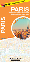
Paris street plan from Blay-Foldex at 1:12, 000 with a street index in a separate detachable booklet which also includes large clear diagrams of the metro/tramway and RER networks. Colouring shows the division of the city into arrondisement.The map shows each arrondisement in a different colour and indicates one way, no entry and pedestrianized streets, car parks, metro and RER stations, pick-up points for the Vélib’ cycles, batobus stops on the Seine, main taxi ranks, etc. Map legend includes English. Next to the map are insets with diagrams of the bus and the metro/tramway/RER network.The index is in a separate booklet attached to the map cover and indicates against each street either the nearest metro station or for longer street the stations along them. The booklet also has
diagrams of the metro/tramway/RER and just RER networks, plus at-a-glance information about access to main services and places of interest outside the city: the CDG and Orly airports, Versailles, Disneyland, Stade de France, etc.PLEASE NOTE: to see the extensive list of Blay-Foldex street plans of other French towns and cities please click on the series link – the series description also includes a comparison between Blay and IGN street plans.
diagrams of the metro/tramway/RER and just RER networks, plus at-a-glance information about access to main services and places of interest outside the city: the CDG and Orly airports, Versailles, Disneyland, Stade de France, etc.PLEASE NOTE: to see the extensive list of Blay-Foldex street plans of other French towns and cities please click on the series link – the series description also includes a comparison between Blay and IGN street plans.

Product Description
Reviews/Comments
Add New
Vouchers
No voucher codes found.
Do you know a voucher code for this product or supplier? Add it to Insights for others to use.
Do you know a voucher code for this product or supplier? Add it to Insights for others to use.
 Denmark