More From Contributor
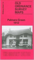
£5.99
The Michelin Street Plan of Palma de Mallorca at 1:10, 000 scale is a comprehensive & accurate, detailed, clear & easy to read high-scale street plan with a street index on the map. Road types are clearly marked, including motorways, dual carriageways, complex junctions, areas subject to restrictions, one-way streets & pedestrian areas. Additional road/street details such as footpaths, bridges, tunnels, arches, stepped streets & pedestrian subways are also shown. Land use is shown through shading, indicating built-up areas, parkl&, undeveloped land & industrial areas. Public buildings including churches, public galleries & museums, hospitals & government buildings are highlighted, & separate highlighting shows other selected building of interest/significance. A range of symbols denote features & places of tourist interest, including UNESCO World Heritage sites, monuments, covered markets, & sport & leisure facilities such as golf courses, gymnasiums, swimming pools & sports grounds. Practical facilities such as hospitals, police, tourist information points, post offices & telephones are also shown. Detailed transportation information is also mapped, showing stations & lines for city rail/tram, & bus & metro stations (routes not shown). Taxi ranks & parking are also marked. Multilingual legend

Includes::
English. To see the list of titles in this series please click on the series link.

...
Archived Product
£4.95
Palma de Mallorca in the Wallpaper City Guide series, published by Phaidon & encompassing a collection of pocket-size guides dedicated to the best design elements in major cities. Compiled by experts at the Wallpaper magazine, the guides are widely recognized for appealing to design-conscious travellers & are aimed at those interested in art, design & architecture. Each guide identifies the best bars, restaurants, hotels, places to shop, leisure activities & excursions with a unique emphasis on the finest examples of unusual architecture & design. Each Wallpaper City Guide has the same layout, with separate tabs allowing readers & travellers to access individual sections easily. The tabs consist of Landmarks, Hotels, 24 Hours, Urban Life, Architour, Shopping, Sports & Escapes. High quality colour photographs appear alongside brief descriptions of each hotel, bar or attraction, highlighting distinctive & unusual styles of architecture & design. Extra pages are provided at the back of each guide, allowing readers to record their own notes & sketches. ...
Archived Product
£5.95
Palma de Mallorca in the Wallpaper* City Guide series, published by Phaidon & encompassing a collection of pocket-size guides dedicated to the best design elements in major cities. Compiled by experts at the Wallpaper* magazine, the guides are widely recognized for appealing to design-conscious travellers & are aimed at those interested in art, design & architecture. Each guide identifies the best bars, restaurants, hotels, places to shop, leisure activities & excursions with a unique emphasis on the finest examples of unusual architecture & design. Each Wallpaper* City Guide has the same layout, with separate tabs allowing readers & travellers to access individual sections easily. The tabs consist of Landmarks, Hotels, 24 Hours, Urban Life, Architour, Shopping, Sports & Escapes. High quality colour photographs appear alongside brief descriptions of each hotel, bar or attraction, highlighting distinctive & unusual styles of architecture & design. Extra pages are provided at the back of each guide, allowing readers to record their own notes & sketches. ...
Archived Product
£6.99
Topographic map at 1:250, 000 from the British Antarctic Survey covering a section of the Palmer Land on the Antarctic Peninsula. BAS ref. for this title is BAS SR19-20/12.PLEASE NOTE: to see the list of other detailed topographic & specialist maps from BAS please click on the series link. BAS maps of wider general interest are listed on our website in a separate series. ...
Archived Product
£6.99
Topographic map at 1:250, 000 from the British Antarctic Survey covering a section of the Palmer Land on the Antarctic Peninsula. BAS ref. number for this title is BAS SR19-20/16.PLEASE NOTE: to see the list of other detailed topographic & specialist maps from BAS please click on the series link. BAS maps of wider general interest are listed on our website in a separate series. ...
Archived Product
£8.50
Palmerston North region in a series of maps covering various districts of New Zeal&, with each title combining a detailed road map with street plans of local towns, all with road & street indexes. The maps are published in two formats: handy Pocket Maps or Pathfinders with, as the publishers put it “ Larger print so you don’t squint”. The road maps, typically around 1:175, 000
- 1:275, 000, show local roads & 4WD tracks. Main sightseeing routes across the country, such as the Pacific Road Highway or Thermal Explorer Highway, are identified by small icons. Railways, local airports & where appropriate, ferry routes are shown. The maps also include selected local hiking tracks. A range of symbols highlight various places of interest & sport or recreational facilities. Topography is indicated by names of mountain ranges & selected peaks. Colouring shows forested areas, with national parks & reserves highlighted. The maps have no geographical coordinates but each one has an index listing names of local roads. Each title also

Includes::
numerous street plans of the main centres of population in the area covered by the road map. The plans are usually at 1:25, 000 to 1:35, 000, & for larger towns an enlargement of the town centre is also provided. The plans shows one way streets, public buildings & various facilities, including sport & recreational centres &, almost invariably, public toilets. Each plan has a separate street index.


...
Archived Product
£17.00
Located northeast of Damascus, in an oasis surrounded by palms & two mountain ranges, the ancient city of Palmyra has the aura of myth. According to the Bible, the city was built by Solomon. Regardless of its actual origins, it was an influential city, serving for centuries as a caravan stop for those crossing the Syrian Desert. It became a Roman province under Tiberius & served as the most powerful commercial center in the Middle East between the first & the third centuries CE. But when the citizens of Palmyra tried to break away from Rome, they were defeated, marking the end of the city`s prosperity. The magnificent monuments from that earlier era of wealth, a resplendent blend of Greco-Roman architecture & local influences, stretched over miles & were among the most significant buildings of the ancient world until the arrival of ISIS. In 2015, ISIS fought to gain control of the area because it was home to a prison where many members of the outlawed Muslim Brotherhood had been held, & ISIS went on to systematically destroy the city & murder many of its inhabitants, including the archaeologist Khaled al-Asaad, the antiquities director of Palymra. In this concise & elegiac book, Paul Veyne, one of Palymra`s most important experts, offers a beautiful & moving look at the history of this significant lost city & why it was & still is important. Today, we can appreciate the majesty of Palmyra only through its pictures & stories, & this book offers a beautifully illustrated memorial that also serves as a lasting guide to a cultural treasure. ...
Archived Product
£12.00
Located northeast of Damascus, in an oasis surrounded by palms & two mountain ranges, the ancient city of Palmyra has the aura of myth. According to the Bible, the city was built by Solomon. Regardless of its actual origins, it was an influential city, serving for centuries as a caravan stop for those crossing the Syrian Desert. It became a Roman province under Tiberius & served as the most powerful commercial center in the Middle East between the first & the third centuries CE. But when the citizens of Palmyra tried to break away from Rome, they were defeated, marking the end of the city`s prosperity. The magnificent monuments from that earlier era of wealth, a resplendent blend of Greco-Roman architecture & local influences, stretched over miles & were among the most significant buildings of the ancient world-until the arrival of ISIS. In 2015, ISIS fought to gain control of the area because it was home to a prison where many members of the outlawed Muslim Brotherhood had been held, & ISIS went on to systematically destroy the city & murder many of its inhabitants, including the archaeologist Khaled al-Asaad, the antiquities director of Palymra. In this concise & elegiac book, Paul Veyne, one of Palymra`s most important experts, offers a beautiful & moving look at the history of this significant lost city & why it was-and still is-important. Today, we can appreciate the majesty of Palmyra only through its pictures & stories, & this book offers a beautifully illustrated memorial that also serves as a lasting guide to a cultural treasure. ...
Archived Product
£7.99
” Palo Alto” is the debut of a powerful new literary voice. Written with an immediacy & sense of place ” Palo Alto” traces the lives of an extended group of teenagers as they experiment with vices of all kinds, struggle with their families & one another, & succumb to self-destructive, often heartless nihilism. Franco presents his characters in all their raw humanity, while at the same time providing insight into the teenage mind. In the classic American tradition of story-cycles such as Sherwood Anderson`s Winesburg, Ohio, ” Palo Alto” presents a stark, vivid, disturbing, but, above all, compassionate portrait of lives on the rough fringes of youth. ...
Archived Product
£17.99
The 1:50 000 topographic map gives a more general picture of the ground features than a basic map. It shows settlements, houses, roads, cultivated areas, waterways, cutting areas, mires, rock exposures, & relief. One map sheet covers an area of 30 x 40 km & one centimetre corresponds to 500 metres on the ground. The 1:50, 000 topographic map is also an ideal complement to nautical charts as it provides useful information about the land areas adjacent to waterways. For example, all Finnish sea areas are covered by 1:50 000 topographic map sheets. ...
Archived Product

Palmers Green 1912

Palmers Green in 1912 in a fascinating series of reproductions of old Ordnance Survey plans in the Alan Godfrey Editions, ideal for anyone interested in the history of their neighbourhood or family. The map shows Palmers Green developing rapidly either side of the GNR Enfield Branch and Green Lanes which run north-south through the centre of the map. Coverage stretches from Warwick Road eastward to Huxley Farm and Blind Lane, and from St John`s church southward to Tottenhall Road, Whittington Road and St Michael`s church, at Bowes. Features include Palmers Green station, tramways, Chequers Green, Bowes isolation hospital, New River, Broomfield Park.About the Alan Godfrey Editions of the 25” OS Series:Selected towns in Great Britain and Ireland are covered by maps showing the
extent of urban development in the last decades of the 19th and early 20th century. The plans have been taken from the Ordnance Survey mapping and reprinted at about 15 inches to one mile (1:4, 340). On the reverse most maps have historical notes and many also include extracts from contemporary directories. Most maps cover about one mile (1.6kms) north/south, one and a half miles (2.4kms) across; adjoining sheets can be combined to provide wider coverage.FOR MORE INFORMATION AND A COMPLETE LIST OF ALL AVAILABLE TITLES PLEASE CLICK ON THE SERIES LINK.
RIP - This product is no longer available on our network. It was last seen on 25.09.2019

This page now acts as a permanent archive for this product. Add more information using the comments box below to ensure it can still be found by future generations.

Use our search facility to see if it is available from an alternative contributor.
  • External links may include paid for promotion
  • Availability: Out Of Stock
  • Supplier: Stanfords
  • SKU: 9780850545012
Availability: In Stock
£3.50

Product Description

Palmers Green in 1912 in a fascinating series of reproductions of old Ordnance Survey plans in the Alan Godfrey Editions, ideal for anyone interested in the history of their neighbourhood or family. The map shows Palmers Green developing rapidly either side of the GNR Enfield Branch & Green Lanes which run north-south through the centre of the map. Coverage stretches from Warwick Road eastward to Huxley Farm & Blind Lane, & from St John`s church southward to Tottenhall Road, Whittington Road & St Michael`s church, at Bowes. Features include Palmers Green station, tramways, Chequers Green, Bowes isolation hospital, New River, Broomfield Park. About the Alan Godfrey Editions of the 25” OS Series: Selected towns in Great Britain & Ireland are covered by maps showing the extent of urban development in the last decades of the 19th & early 20th century. The plans have been taken from the Ordnance Survey mapping & reprinted at about 15 inches to one mile (1:4, 340). On the reverse most maps have historical notes & many also include extracts from contemporary directories. Most maps cover about one mile (1.6kms) north/south, one & a half miles (2.4kms) across; adjoining sheets can be combined to provide wider coverage.FOR MORE INFORMATION & A COMPLETE LIST OF ALL AVAILABLE TITLES PLEASE CLICK ON THE SERIES LINK.

Reviews/Comments

Add New

Price History

Vouchers

No voucher codes found.
Do you know a voucher code for this product or supplier? Add it to Insights for others to use.

Facebook

Jargon Buster

Contemporary - Modern era design
Contemporary - A design reference to indicate post war modern design
History - Anything that happens in the past. An acedemic subject.
Road - a manmade lane or a path that is used to speed up travel.
Contemporary - An object that is living in the same time.
Ideal - Something that satisfies a perfect criteria.
Family - A group of people that live together made up from parents and children.

Supplier Information

Stanfords
Stanfords was established in 1853 and opened their iconic Covent Garden flagship store in 1901. They have become the top retailer of maps, travel books and accessories in the UK and arguably offer the largest selection of maps and travel books worldwide. Famous names such as Captain Robert Falcon Scott, Ranulph Fiennes and Michael Palin have purchased from Stanfords. They now have a shop in Bristol and both stores together with other venues operate a calendar of events including talks, book signings and exhibitions. As a specialist map retailer, the map selection is comprehensive and includes road maps, street maps and walking maps from worldwide destinations, as well as a selection of world atlases and wall maps. Books include travel guides and travel literature. Stanfords also stock globes, from miniatures made of blue marble to magnificent floor-standing globes. The website features a selection of interesting articles on travel topics.
Page Updated: 2023-11-12 20:15:36

Community Generated Product Tags

Oh No! The productWIKI community hasn't generated any tags for this product yet!
Menu