More From Contributor
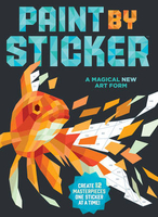
£9.99
Map No. 145, Pagosa Springs
- Bayfield, CO, in an extensive series of GPS compatible, contoured hiking maps of USA’s national
...
Archived Product
£2.95
Paignton in 1904 in a fascinating series of reproductions of old Ordnance Survey plans in the Alan Godfrey Editions, ideal for anyone interested in the history of their neighbourhood or family. Selected towns in Great Britain & Ireland are covered by maps showing the extent of urban development in the last decades of the 19th & early 20th century. In this title: this detailed map covers the heart of the Torbay town of Paignton, stretching from the coast inland to St Mary's Hill & Primley Park, & from Fernham Road southward to Roundham Head. Features include railway with station, Queen's Park, Southfield area, Polsham area, part of St Michaels, The Green, St John's church, Christ Church, Paignton Harbour, Promenade Pier, Hotel Redcliffe, Esplanade Hotel, St Andrew's church, Public Hall, town centre with individual buildings neatly shown, schools, Victoria Park, Oldenburg House, remains of Bishop's Palace, etc. On the reverse are extracts from a 1906 directory, listing Private Residents. About the Alan Godfrey Editions of the 25 ...
Archived Product
£3.50
Paignton in 1904 in a fascinating series of reproductions of old Ordnance Survey plans in the Alan Godfrey Editions, ideal for anyone interested in the history of their neighbourhood or family. The map covers the heart of the Torbay town of Paignton, stretching from the coast inland to St Mary`s Hill & Primley Park, & from Fernham Road southward to Roundham Head. Features include railway with station, Queen`s Park, Southfield area, Polsham area, part of St Michaels, The Green, St John`s church, Christ Church, Paignton Harbour, Promenade Pier, Hotel Redcliffe, Esplanade Hotel, St Andrew`s church, Public Hall, Victoria Park, Oldenburg House, remains of Bishop`s Palace, etc. On the reverse are extracts from a 1906 directory, listing Private Residents. About the Alan Godfrey Editions of the 25” OS Series Selected towns in Great Britain & Ireland are covered by maps showing the extent of urban development in the last decades of the 19th & early 20th century. The plans have been taken from the Ordnance Survey mapping & reprinted at about 15 inches to one mile (1:4, 340). On the reverse most maps have historical notes & many also include extracts from contemporary directories. Most maps cover about one mile (1.6kms) north/south, one & a half miles (2.4kms) across; adjoining sheets can be combined to provide wider coverage.FOR MORE INFORMATION & A COMPLETE LIST OF ALL AVAILABLE TITLES PLEASE CLICK ON THE SERIES LINK. ...
Archived Product
£12.99
Topographic survey of France at 1:25, 000 in IGN`s excellent TOP25 / Série Bleue series. All the maps are GPS compatible, with a 1km UTM grid plus latitude & longitude lines at 5’ intervals. Contours are at 5m intervals except for mountainous areas where the maps have contours at 10m intervals, vividly enhanced by hill shading & graphics for rocky terrain. Colouring with graphics indicates different types of vegetation or land use (deciduous or coniferous forests, moors, orchards, vineyards, etc). PLEASE NOTE: coverage of France at this scale is currently being revised – the format & the presentation of each title are indicated by the letters at the end of its Sheet Reference number (e.g. 0416ET, 3531ETR, 1923SB, etc.)MAPS WITH FULL TOURIST OVERPRINT & AN ENGLISH MAP LEGEND: all TOP25 maps & the SB editions of Série Bleue have an overprint highlighting waymarked walking trails including long-distance GR routes &, where appropriate, ski routes. Symbols indicate campsites, gîtes d’etape, refuges, equestrian centres & other recreational facilities or sites, tourist information centres, cultural heritage, etc. Towns & locations of particular interest are highlighted.- ET or OT = single-sided TOP25 map covering approx. 29x 21 km / 18x 13 miles.- ETR or OTR = waterproof & tear resistant TOP25 map covering the same area as the corresponding ET or OT number, but double-sided, printed on a smaller size sheet with a good overlap between the sides.- SB = Série Bleue map with full tourist overprint; these maps, first introduced in summer 2014, each cover approx. 29x 24km / 18x 15 miles.SÉRIE BLEUE maps with numbers ending in E (Est) or O (Ouest): most editions now indicate the GR routes, but do not show any other tourist information. Map legend is in French only. Each map covers approx. 14x 20km / 9x 12 miles. ...
Archived Product
£7.99
Paint by Sticker Kids is the same compelling craft first introduced in Paint by Sticker, but just for kids! The book


...
Archived Product
£11.99
A compelling activity for crafters & artists, doodlers & colourers of all ages, each PAINT BY STICKER book

Includes::


...
Archived Product
£9.99
In Paint by Sticker: Travel, twelve vintage posters take us to the Taj Mahal, a canal in Venice, Monaco`s Grand Prix, & other destinations from the golden age of travel. The original images are rendered in low-poly, a computer graphics style using geometric polygon shapes to create a 3D effect. As in paint-by-number, each template is divided into dozens of spaces, each with a number that corresponds to a particular sticker. Find the sticker, peel it, & place it in the right space. Add the next, & the next, & the next -- it`s an activity that`s utterly absorbing, both in the pleasure of peeling & sticking & the growing satisfaction of watching a ”painting” come to life, emerging from a flat black-&-white illustration to a dazzling image with colour, body, & spirit. ...
Archived Product
£3.99
These colourful Paint Job Dots Stickers are ideal for decorating your bike, tool box & anything you want to give a personalised look. In the box you will find 25 leaves containing a total of 50 dots in 4 different bright colours. This collection is a fantastic idea for cyclists or anyone wishing to add artistic & colourful details to their ride. ...
Archived Product
£3.99
These colourful Paint Job Flowers Stickers are ideal for decorating your bike, tool box & anything you want to give a personalised look. In the box you will find 25 leaves containing a total of 50 flowers in 4 different bright colours. This collection is a fantastic idea for cyclists or anyone wishing to add artistic & colourful details to their ride. ...
Archived Product

Paint By Sticker

Paint by Sticker is a compelling new craft for all ages, and the book includes everything you need to create 12 vibrant, full-colour ”paintings”-a dozen illustrated templates printed on perforated card stock, and 24 pages of stickers to fill in and create the artwork. The images are rendered in ”low-poly, ” a computer graphics style using geometric polygon shapes to create a 3-D effect. As in paint-by-number, each template is divided into hundreds of spaces, each with a number that corresponds to a particular sticker. Find the sticker, peel it, and place it in the right space. Add the next, and the next, and the next-it`s an activity that`s utterly absorbing, both in the mindful pleasure of peeling and sticking and the growing satisfaction of watching a ”painting”
come to life, emerging from a flat black-and-white illustration to a dazzling image with colour, body, spirit. Still life with fruit. A classic urban landscape. Sunflowers, of course. Two rowboats on a peaceful lake. A dynamic hummingbird in mid-flight. Each suitable for framing.
RIP - This product is no longer available on our network. It was last seen on 25.09.2019

This page now acts as a permanent archive for this product. Add more information using the comments box below to ensure it can still be found by future generations.

Use our search facility to see if it is available from an alternative contributor.
  • External links may include paid for promotion
  • Availability: Out Of Stock
  • Supplier: Stanfords
  • SKU: 9780761187233
Availability: In Stock
£10.98

Product Description

Paint by Sticker is a compelling new craft for all ages, & the book

Includes::
everything you need to create 12 vibrant, full-colour ”paintings”-a dozen illustrated templates printed on perforated card stock, & 24 pages of stickers to fill in & create the artwork. The images are rendered in ”low-poly, ” a computer graphics style using geometric polygon shapes to create a 3-D effect. As in paint-by-number, each template is divided into hundreds of spaces, each with a number that corresponds to a particular sticker. Find the sticker, peel it, & place it in the right space. Add the next, & the next, & the next-it`s an activity that`s utterly absorbing, both in the mindful pleasure of peeling & sticking & the growing satisfaction of watching a ”painting” come to life, emerging from a flat black-&-white illustration to a dazzling image with colour, body, spirit. Still life with fruit. A classic urban landscape. Sunflowers, of course. Two rowboats on a peaceful lake. A dynamic hummingbird in mid-flight. Each suitable for framing.

Reviews/Comments

Add New

Intelligent Comparison

Oooops!
We couldn't find anything!
Perhaps this product's unique.... Or perhaps we are still looking for comparisons!
Click to bump this page and we'll hurry up.

Price History

Vouchers

No voucher codes found.
Do you know a voucher code for this product or supplier? Add it to Insights for others to use.

Facebook

Jargon Buster

Black - A colour which does not emit any colour of the spectrum. Black absorbs all frequencies of the spectrum.
Flight - The process of of an object moving through the air
White - A colour combining all colours
Computer - A programmable electronic machine which stores and manipulates data.
Graphics - A general term for visual aspects of an item/display
Colour - The categorised spectrum of light visable to humans
Sticker - A label that has an adhesive glue on the back and generally pictures on the front.
Classic - Something that is still like it was originally a high quality standard.

Supplier Information

Stanfords
Stanfords was established in 1853 and opened their iconic Covent Garden flagship store in 1901. They have become the top retailer of maps, travel books and accessories in the UK and arguably offer the largest selection of maps and travel books worldwide. Famous names such as Captain Robert Falcon Scott, Ranulph Fiennes and Michael Palin have purchased from Stanfords. They now have a shop in Bristol and both stores together with other venues operate a calendar of events including talks, book signings and exhibitions. As a specialist map retailer, the map selection is comprehensive and includes road maps, street maps and walking maps from worldwide destinations, as well as a selection of world atlases and wall maps. Books include travel guides and travel literature. Stanfords also stock globes, from miniatures made of blue marble to magnificent floor-standing globes. The website features a selection of interesting articles on travel topics.
Page Updated: 2023-11-12 20:15:36

Community Generated Product Tags

Oh No! The productWIKI community hasn't generated any tags for this product yet!
Menu