More From Contributor
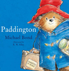
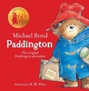
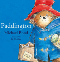
£4.99
Camera? Check. Socks? Yup. Sunscreen? Sorted. From beach getaways & city breaks to adventure travel & winter sports, this handy checklist will ensure nothing ever gets left behind again. Say goodbye to mentally checking off your holiday essentials, hoping you remember your phone charger, playing cards & that little bottle of hand sanitiser. With Lonely Planet`s Packing List, everything you`ll ever need is right in front of you, waiting to be struck-through or ticked off. Packing List

Features:
- City, beach, adventure, family & backpacking themes
- Essentials, electronics, clothes, hygiene & miscellaneous categories
- Colour-coded themes for easy access
- 80 tear-off double-sided sheets


...
Archived Product
£8.99
Brigid Keenan was a successful young London fashion journalist when she fell in love with a diplomat & left behind the gilt chairs of the Paris salons for a large chicken shed in Nepal. Her bestselling account of life as a `trailing spouse`, Diplomatic Baggage, won the hearts of thousands in countries all over the world. Now, in her further adventures, we find Brigid in Kazakhstan, where AW, her husb&, contracts Lyme disease from a tick, the local delicacy is horse meat sausage & Brigid`s visit to a market leads to a full-scale riot from which she requires a police escort. Then, as the prospect retirement looms, Brigid finds herself on the cusp of a whole new world: shuttling between London, Brussels & their last posting in Azerbaijan, navigating her daughters` weddings while coping with a cancer diagnosis, & getting a crash course in gr&-motherhood as she helps organise a literature festival in Palestine. Along the way, dauntless & wildly funny as ever, Brigid learns that packing up doesn`t mean packing in as she discovers that retiring & moving back home could just be her biggest challenge yet. ...
Archived Product
£11.50
Topographic survey of France at 1:25, 000 in IGN`s excellent TOP25 / Série Bleue series. All the maps are GPS compatible, with a 1km UTM grid plus latitude & longitude lines at 5’ intervals. Contours are at 5m intervals except for mountainous areas where the maps have contours at 10m intervals, vividly enhanced by hill shading & graphics for rocky terrain. Colouring with graphics indicates different types of vegetation or land use (deciduous or coniferous forests, moors, orchards, vineyards, etc). PLEASE NOTE: coverage of France at this scale is currently being revised – the format & the presentation of each title are indicated by the letters at the end of its Sheet Reference number (e.g. 0416ET, 3531ETR, 1923SB, etc.)MAPS WITH FULL TOURIST OVERPRINT & AN ENGLISH MAP LEGEND: all TOP25 maps & the SB editions of Série Bleue have an overprint highlighting waymarked walking trails including long-distance GR routes &, where appropriate, ski routes. Symbols indicate campsites, gîtes d’etape, refuges, equestrian centres & other recreational facilities or sites, tourist information centres, cultural heritage, etc. Towns & locations of particular interest are highlighted.- ET or OT = single-sided TOP25 map covering approx. 29x 21 km / 18x 13 miles.- ETR or OTR = waterproof & tear resistant TOP25 map covering the same area as the corresponding ET or OT number, but double-sided, printed on a smaller size sheet with a good overlap between the sides.- SB = Série Bleue map with full tourist overprint; these maps, first introduced in summer 2014, each cover approx. 29x 24km / 18x 15 miles.SÉRIE BLEUE maps with numbers ending in E (Est) or O (Ouest): most editions now indicate the GR routes, but do not show any other tourist information. Map legend is in French only. Each map covers approx. 14x 20km / 9x 12 miles. ...
Archived Product
£23.99
Karttakeskus’ Water touring maps are a completely new type of map series. The pre-folded maps made from waterproof & rip-proof material can fit into a small space on the boat, but when opened, they cover a wide area. In this way, the water touring map is e.g. an excellent planning tool alongside electronic navigation solutions, offering a wide overview for e.g. route planning. On the other h&, the waterproof material makes the map easy to handle in e.g. an open boat or sailing boat. Water touring maps: In land areas, the maps have been supplemented with the National Land Survey of Finland’s Topographic Database material. New map sheet division. Size 70 × 100 cm, folded 23.3 × 11.3 cm. Additional themes incl. slipways & camp fire sites & landfalls. Scale in maritime areas 1:60 000, inland waterways 1:50 000 Base map source: Finnish Transport Agency. Not for navigation use. Does not meet the requirements of an official nautical chart. ...
Archived Product
£6.99
The classic story of everyone`s favourite bear, Paddington. Now available in board book format
- perfect for tiny paws! Paddington
...
Archived Product
£6.99
The classic story of everyone`s favourite bear, Paddington. Now available in board book format
- perfect for tiny paws! Paddington
...
Archived Product
£9.99
Three favourite stories of Paddington, the bear from Darkest Peru, brought together in one volume! This special edition brings together three favourite classic adventures
- Paddington in the Garden, Paddington at the Carnival & Paddington & the Grand Tour. Whether he is gardening, walking along the canal, or seeing the sights of London
- as always
- there is never a dull moment when Paddington is around!


...
Archived Product
£6.99
Paddington is introduced to younger readers in this pre-school picture book, starring one of the world`s best-loved characters, Paddington Bear, now a major movie star! Reissued with attractive new cover branding. When Paddington Bear goes to the beach, nothing goes quite according to plan.. .especially when, one by one, he is joined by ten hungry seagulls. Will Paddington`s lunchtime snack be safe? Pre-schoolers will love counting with everyone`s favourite bear, Paddington! ...
Archived Product
£3.50
Paddington in 1872 in a fascinating series of reproductions of old Ordnance Survey plans in the Alan Godfrey Editions, ideal for anyone interested in the history of their neighbourhood or family. Three versions of this map show how the area developed across the years. The maps each cover the same area, stretching from Chepstow Place & Leinster Square eastward to Seymour Place & Bryanston Square; from Harrow Road southward to Kensington Gardens. Features include Paddington station & its approaches, Royal Oak & Bishop`s Road stations, tramways, Paddington Basin, parts of the Metropolitan/ Circle Line, Bayswater & part of Hyde Park. Churches include St Mary`s Paddington Green, Christ Church Lancaster Gate, St John`s Southwick Crescent, St Mary`s Upper York St, etc, & streets Westbourne Grove, Praed Street, Edgware Road, Uxbridge Road, Craven Road & many more. Each map also

Includes::
extracts from contemporary directories. About the Alan Godfrey Editions of the 25” OS Series: Selected towns in Great Britain & Ireland are covered by maps showing the extent of urban development in the last decades of the 19th & early 20th century. The plans have been taken from the Ordnance Survey mapping & reprinted at about 15 inches to one mile (1:4, 340). On the reverse most maps have historical notes & many also include extracts from contemporary directories. Most maps cover about one mile (1.6kms) north/south, one & a half miles (2.4kms) across; adjoining sheets can be combined to provide wider coverage.FOR MORE INFORMATION & A COMPLETE LIST OF ALL AVAILABLE TITLES PLEASE CLICK ON THE SERIES LINK.

...
Archived Product
£3.50
Paddington in 1893 in a fascinating series of reproductions of old Ordnance Survey plans in the Alan Godfrey Editions, ideal for anyone interested in the history of their neighbourhood or family. Three versions of this map show how the area developed across the years. The maps each cover the same area, stretching from Chepstow Place & Leinster Square eastward to Seymour Place & Bryanston Square; from Harrow Road southward to Kensington Gardens. Features include Paddington station & its approaches, Royal Oak & Bishop`s Road stations, tramways, Paddington Basin, parts of the Metropolitan/ Circle Line, Bayswater & part of Hyde Park. Churches include St Mary`s Paddington Green, Christ Church Lancaster Gate, St John`s Southwick Crescent, St Mary`s Upper York St, etc, & streets Westbourne Grove, Praed Street, Edgware Road, Uxbridge Road, Craven Road & many more. Each map also

Includes::
extracts from contemporary directories. About the Alan Godfrey Editions of the 25” OS Series: Selected towns in Great Britain & Ireland are covered by maps showing the extent of urban development in the last decades of the 19th & early 20th century. The plans have been taken from the Ordnance Survey mapping & reprinted at about 15 inches to one mile (1:4, 340). On the reverse most maps have historical notes & many also include extracts from contemporary directories. Most maps cover about one mile (1.6kms) north/south, one & a half miles (2.4kms) across; adjoining sheets can be combined to provide wider coverage.FOR MORE INFORMATION & A COMPLETE LIST OF ALL AVAILABLE TITLES PLEASE CLICK ON THE SERIES LINK.

...
Archived Product

Paddington

Join Paddington and the Browns as they start their adventures at Paddington Station and relive their treasured story in this stylish picture book. Paddington Bear first met the Brown family at a railway station - Paddington station, in fact. He had travelled all the way from Darkest Peru with only a jar of marmalade, a suitcase and a label reading `Please look after this bear`. Without further ado, Mr and Mrs Brown promptly welcomed the adventurous bear into their family, and in honour of their meeting place they named him Paddington. The Browns soon discover that Paddington is a most unusual bear. Ordinary things - like having a bath - become quite extraordinary when a bear called Paddington is around. Now this treasured story is available as a charming picture book that even the
youngest children will enjoy.
RIP - This product is no longer available on our network. It was last seen on 25.09.2019

This page now acts as a permanent archive for this product. Add more information using the comments box below to ensure it can still be found by future generations.

Use our search facility to see if it is available from an alternative contributor.
  • External links may include paid for promotion
  • Availability: Out Of Stock
  • Supplier: Stanfords
  • SKU: 9780007236336
Availability: In Stock
£6.99

Product Description

Join Paddington & the Browns as they start their adventures at Paddington Station & relive their treasured story in this stylish picture book. Paddington Bear first met the Brown family at a railway station
- Paddington station, in fact. He had travelled all the way from Darkest Peru with only a jar of marmalade, a suitcase & a label reading ` Please look after this bear`. Without further ado, Mr & Mrs Brown promptly welcomed the adventurous bear into their family, & in honour of their meeting place they named him Paddington. The Browns soon discover that Paddington is a most unusual bear. Ordinary things
- like having a bath
- become quite extraordinary when a bear called Paddington is around. Now this treasured story is available as a charming picture book that even the youngest children will enjoy.

Reviews/Comments

Add New

Intelligent Comparison

Oooops!
We couldn't find anything!
Perhaps this product's unique.... Or perhaps we are still looking for comparisons!
Click to bump this page and we'll hurry up.

Price History

Vouchers

No voucher codes found.
Do you know a voucher code for this product or supplier? Add it to Insights for others to use.

Facebook

Jargon Buster

Brown - A colour, commonly associated with earth or soil
Stylish - A desirable design or layout
Paddington - An area in the city of Westminster, London
Unusual - Something unique and different.
Children - A young life form within the early stages of physical development,
Family - A group of people that live together made up from parents and children.

Supplier Information

Stanfords
Stanfords was established in 1853 and opened their iconic Covent Garden flagship store in 1901. They have become the top retailer of maps, travel books and accessories in the UK and arguably offer the largest selection of maps and travel books worldwide. Famous names such as Captain Robert Falcon Scott, Ranulph Fiennes and Michael Palin have purchased from Stanfords. They now have a shop in Bristol and both stores together with other venues operate a calendar of events including talks, book signings and exhibitions. As a specialist map retailer, the map selection is comprehensive and includes road maps, street maps and walking maps from worldwide destinations, as well as a selection of world atlases and wall maps. Books include travel guides and travel literature. Stanfords also stock globes, from miniatures made of blue marble to magnificent floor-standing globes. The website features a selection of interesting articles on travel topics.
Page Updated: 2023-11-12 20:15:36

Community Generated Product Tags

Oh No! The productWIKI community hasn't generated any tags for this product yet!
Menu