More From Contributor

£11.99
Ă-tztaler Alps: Geigenkamm area of the Alps in a combined hiking & ski edition at 1:25, 000 from a series of detailed, GPS compatible maps published by the DAV
- Deutscher Alpenverein & produced by the German & Austrian Alpine Clubs using cartography from their respective survey organizations. Maps in this series have topography vividly presented by contours at 20 metres intervals, enhanced by shading & finely drawn graphic relief. An overprint highlights hiking paths and/or ski routes (please see the note below), campsites & various types of mountain huts & refuges. The area covered by each map varies according to the scale; for 1:25, 000 maps it is Approx. 25x 18 km (15 x 11 miles). The maps have a 1-km UTM grid, plus margin ticks with latitude & longitude at intervals of 1`. Map legend is in German only.PLEASE NOTE – THE OVERPRINT FOR HIKING and/or SKI ROUTES: all Sheet Ref. numbers shown on the accompanying grid are available with an overprint highlighting hiking trails, indicating sections with fixed climbing ropes &, where appropriate, the waymarking route numbers. Several titles are now published with both hiking & ski routes on them. Other areas are covered by two separate maps: a hiking edition plus a ski edition. The type of the overprint is indicated in our title of each map. To see the list of titles in this series please click on the series link.
...
Archived Product
£11.99
One of the titles in a series of topographic maps covering much of north-west Africa, produced as part of the IMW* project in 1960’s. Each map covers an area spanning 6° in longitude & 4° in latitude. There is some variation in colouring & the depiction of terrain, but hill-shading, spot heights & contours are used to show the general relief. Additional graphics show features such as dunes, rock outcrops, cliffs, sand areas, escarpments, marshes, seasonal lakes & watercourses, & areas liable to flooding. Bathymetric contours are also included. Communications detail

Includes::
roads, major trails & railways, although there is some inconsistency in colouring & the extent of classification, e.g. not all maps distinguish seasonal roads. On most maps intermediate road distances are indicated on main routes. Symbols show airports, mosques, mines, oil & gas fields, lighthouses, ruins & significant isolated buildings. Administrative boundaries are marked & latitude & longitude lines are drawn at 1° intervals, with further margin ticks at 1’ intervals. The map legend is in French only on some sheets, & in English & French on others.* The International Map of the World was a project conceived in the early 20th century to compile a world map series at 1:1, 000, 000 through the efforts of participating nations. The value of the program has declined since 1970 & the IMW is no longer regarded as an active international series.

...
Archived Product
£10.00
Ouarzazate & the region to the east of it including Skoura & the western part of Jbel Sarhro in a series of GPS compatible maps at 1:160, 000 published by EWP & West Col Productions & covering Morocco’s Atlas Mountains with its neighbouring deserts & coastal areas. The maps use the cartography of the Russian military survey of the area, providing a very detailed representation of the terrain, with contours at 40m intervals plus graphics and/or colouring to show features such as cliffs, ravines, sand ridges & dunes, various types of vegetation, etc. All place names are given in the Latin alphabet. Road information

Includes::
unsurfaced roads & tracks. Where main roads meet the edge of the map, the distance to the next large town is stated. Selected high passes are annotated to show months when passable. Railways & local airports are marked & a range of symbols indicate various landmarks & places of interest, including mountain refuges & forestry buildings, oasis, caves, etc. Interesting locations are highlighted. Each sheet covers 40’ of latitude & 1° of longitude & has a grid based on the Kronstadt system which, according to the publishers’ notes, is related closely to the UTM system & is suitable for a GPS set to UTM or MGRS. The maps also have either additional margin ticks or a grid for latitude & longitude. On the reverse are illustrated notes about the area, plus a glossary of Berber terms & notes on transliteration of local names. Map legend & all the texts are in English & French.

...
Archived Product
£9.50
Topographical survey of Belgium at 1:20, 000 from Nationaal Geografisch Instituut / Institut Géographique National, the country’s national survey organization. Each 20K map covers one quarter of the corresponding 1:50, 000 map (with adjustments in the border & coastal areas). The maps provide all the information expected of topographic mapping at this scale & in addition have an unusually large amount of vegetation and/or land use information (different types of woodlands, gardens, orchards, heath, etc). The maps have a 1-km UTM grid, with margin ticks for latitude & longitude at intervals of 1`. Map legend & a glossary of terms used on the maps include English. Stanfords keeps as regular stock 20K maps for the World War I battlefields around the Ypres, Messines & Passchendaele, & for the area of the Battle of Waterloo. The 1:20, 000 survey covers the whole of Belgium & maps for other regions can be supplied as special orders. To see the list of titles in this series please click on the series link.PLEASE NOTE: the Long-Distance Footpaths Map of Belgium at 1:300, 000 which shows the division of Belgium into the 50K survey sheets can also be used to see in more detail coverage by the 20K maps. ...
Archived Product
£29.99
Map No. 3322, Oudtshoorn, in South Africa’s official topographic survey at 1:250, 000 from the country’s national survey organization, the Chief Directorate of Surveys & Mapping. The maps have altitude colouring & contours at 50m or 100m intervals, depending on the map edition, plus spot heights. Deserts, marshes, dry pans, perennial & seasonal water features, etc, as well as protected areas are shown. The maps present the country’s road & rail networks & include the usual information expected on topographic mapping at this scale, although in more rapidly developing areas road information may not necessarily be up to date. Also indicated are magisterial district & provincial boundaries. Latitude & longitude values are shown in the margins at 5` intervals together with South African grid co-ordinates. Typically, each sheet covers an area of one degree of latitude & two degrees of longitude. The projection used is Gauss Conformal. The legend is in English & Afrikaans. ...
Archived Product
£11.99
One of the titles in a series of topographic maps covering much of north-west Africa, produced as part of the IMW* project in 1960’s. Each map covers an area spanning 6° in longitude & 4° in latitude. There is some variation in colouring & the depiction of terrain, but hill-shading, spot heights & contours are used to show the general relief. Additional graphics show features such as dunes, rock outcrops, cliffs, sand areas, escarpments, marshes, seasonal lakes & watercourses, & areas liable to flooding. Bathymetric contours are also included. Communications detail

Includes::
roads, major trails & railways, although there is some inconsistency in colouring & the extent of classification, e.g. not all maps distinguish seasonal roads. On most maps intermediate road distances are indicated on main routes. Symbols show airports, mosques, mines, oil & gas fields, lighthouses, ruins & significant isolated buildings. Administrative boundaries are marked & latitude & longitude lines are drawn at 1° intervals, with further margin ticks at 1’ intervals. The map legend is in French only on some sheets, & in English & French on others.* The International Map of the World was a project conceived in the early 20th century to compile a world map series at 1:1, 000, 000 through the efforts of participating nations. The value of the program has declined since 1970 & the IMW is no longer regarded as an active international series.

...
Archived Product
£9.95
Detailed map of the south-western corner of Brittany, west of Quimper, covering an area of Approx. 40 x 44 km. An overprint highlights local footpaths, bridleways & cycling routes, as well as places of interest, including the famous stone circles. IGN ...
Archived Product
£3.95
Ouistreham (Pegasus Bridge) in a series of reproductions of the Bigot Plans prepared by the GSGS (Geographic Section General Staff) for the D-Day landings in Normandy in June 1944, showing German defences & other obstacles facing the invading Allied troops. The map is centred on the bridge that is now known as Pegasus Bridge, near Bénouville & Ranville, the scene of the heroic glider landings. The map is double-sided, extending from Ouistreham in the north southward to Herouvillette & westward beyond Cazelle. The Bigot Plans were classified Top Secret & issued under the highest level of ” Need to Know” regulations. They were updated with aerial & intelligence information to 19th May 1944, less than three weeks before the landings. The reprints, taken from the 1:25, 000 series catalogued as GSGS 4347, are very detailed & show the terrain, obstacles & defences that the Allied forces expected to meet, with blue colour indicating those confirmed & violet those not verified. Each sheet has a topographic legend, with the two maps covering the Omaha Beach & the Sword & Juno Beaches also carrying an extensive Defence Legend for defence works, weapon types, obstacles, minefields, personnel accommodation, etc. Also provided are notes about the D-Day Landing & the particular area covered by each map.* PLEASE NOTE: only three sheets have been published so far, covering Omaha Beach, Sword & Juno Beaches, & the Pegasus Bridge area. Maps shown in grey on our series grid have not been reproduced. ...
Archived Product

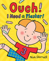
Ouch! I Need A Plaster! Ne

Have you ever bashed your nose? Scraped your knee? Stubbed your toe? Then this story is just for you! Come and meet Paul, Greg and Jacinta who all know how to say, `Ouch! I Need a Plaster!` Sure to make everything better, `Ouch!` is a fun counting book for all tree-climbers, adventurers and budding doctors everywhere. Now available as a stunning gift edition board book.
RIP - This product is no longer available on our network. It was last seen on 25.09.2019

This page now acts as a permanent archive for this product. Add more information using the comments box below to ensure it can still be found by future generations.

Use our search facility to see if it is available from an alternative contributor.
  • External links may include paid for promotion
  • Availability: Out Of Stock
  • Supplier: Stanfords
  • SKU: 9781407174075
Availability: In Stock
£5.99

Product Description

Have you ever bashed your nose? Scraped your knee? Stubbed your toe? Then this story is just for you! Come & meet Paul, Greg & Jacinta who all know how to say, ` Ouch! I Need a Plaster!` Sure to make everything better, ` Ouch!` is a fun counting book for all tree-climbers, adventurers & budding doctors everywhere. Now available as a stunning gift edition board book.

Reviews/Comments

Add New

Intelligent Comparison

Oooops!
We couldn't find anything!
Perhaps this product's unique.... Or perhaps we are still looking for comparisons!
Click to bump this page and we'll hurry up.

Price History

Vouchers

No voucher codes found.
Do you know a voucher code for this product or supplier? Add it to Insights for others to use.

Facebook

Jargon Buster

Fun - Something that provides amusement or enterainment
Gift - Something that is presented without expecting anything in return

Supplier Information

Stanfords
Stanfords was established in 1853 and opened their iconic Covent Garden flagship store in 1901. They have become the top retailer of maps, travel books and accessories in the UK and arguably offer the largest selection of maps and travel books worldwide. Famous names such as Captain Robert Falcon Scott, Ranulph Fiennes and Michael Palin have purchased from Stanfords. They now have a shop in Bristol and both stores together with other venues operate a calendar of events including talks, book signings and exhibitions. As a specialist map retailer, the map selection is comprehensive and includes road maps, street maps and walking maps from worldwide destinations, as well as a selection of world atlases and wall maps. Books include travel guides and travel literature. Stanfords also stock globes, from miniatures made of blue marble to magnificent floor-standing globes. The website features a selection of interesting articles on travel topics.
Page Updated: 2023-11-12 20:15:36

Community Generated Product Tags

Oh No! The productWIKI community hasn't generated any tags for this product yet!
Menu