
 United Kingdom
 France
 Germany
 Netherlands
 Sweden
 USA
USA
 Italy
Italy
 Spain
Spain
More From Contributor


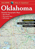
Oklahoma Benchmark Recreation Map
The Oklahoma Recreation Map is the first map product to accurately represent The Sooner State`s highway detail and the richness of recreation opportunities. One side provides a full state map that features Public & Tribal Lands, land cover (forest, grassland, cropland, & wetland), extensive highway networks, point-to-point mileages, recreation sites, Roadside America attractions, campgrounds, parks & wildlife areas, boating & fishing access points, and public hunting areas. The reverse side features categorized recreation listings with helpful descriptions, current contact information, and map grid references.
Product Description
Reviews/Comments
Add New
Vouchers
No voucher codes found.
Do you know a voucher code for this product or supplier? Add it to Insights for others to use.
Do you know a voucher code for this product or supplier? Add it to Insights for others to use.
 Denmark