
 United Kingdom
 France
 Germany
 Netherlands
 Sweden
 USA
USA
 Italy
Italy
 Spain
Spain
More From Contributor


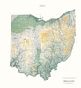


Ohio Northeastern
Northeast Ohio in a series of Rand McNally’s regional road maps covering the environs of main US cities. Centered on Cleveland, coverage extends from the shores of Lake Erie southwards beyond Mansfield and New Philadelphia, westwards beyond Sandusky and east to the state boundary with Pennsylvania. Other communities covered by this map include Ashtabula, Akron, Canton, East Liverpool, Lakewood, Massillon, Warren, Wooster and Youngstown. Also provided is a street plan of downtown Cleveland.Maps in this series present the road network on a clear background with no relief shading to show the area’s topography, but with national or state parks, forests and other protected areas indicated by colouring. Roads are numbered and/or named, showing toll highways, exit numbers of
interchanges, services and rest areas. Local airports are marked, but railways and other urban transport lines are not included unless specifically indicated in the individual description. Each town is presented in a different colour, providing those unfamiliar with the region a very clear picture of the area. Various places of interest and facilities are highlighted, including cultural and historical sites, educational institutions, sport and recreational facilities, etc. Each title is indexed. Several maps also include enlargements of the downtown area, plans of international airports, a mileage and driving times diagram for a much wider region than covered by the main map, etc - for more information please see the individual descriptions.To see all the titles in this series
please click on the series link.
Product Description
Reviews/Comments
Add New
Vouchers
No voucher codes found.
Do you know a voucher code for this product or supplier? Add it to Insights for others to use.
Do you know a voucher code for this product or supplier? Add it to Insights for others to use.
 Denmark