
 United Kingdom
 France
 Germany
 Netherlands
 Sweden
 USA
USA
 Italy
Italy
 Spain
Spain
More From Contributor


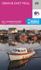
Oban & Mull Tourist Map
Six types of road are detailed, from primary roads to simple tracks. Altitude colouring (different colours depending upon height of the land) is used to show clearly the topography of the area. Campsites, caravan sites, mountain rescue stations, pony trekking centres, golf courses are clearly marked and a selection of places of interest are described in more detail along the bottom of the map. Indexed.
Product Description
Reviews/Comments
Add New
Intelligent Comparison
Archived Product
Oban And Mull Tourist Map Stanfords
£4.99
Vouchers
No voucher codes found.
Do you know a voucher code for this product or supplier? Add it to Insights for others to use.
Do you know a voucher code for this product or supplier? Add it to Insights for others to use.
 Denmark