More From Contributor
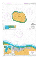
£24.99
Plans included: Tutuila Island 1:60, 000 Swains Island 1:50, 000 Pago Pago Harbour 1:25, 000 Manua Island 1:100, 000 Rose Atoll 1:100, 000 Nautical charts for New Zeal&, created by Land Information New Zealand (LINZ), are printed on demand at Stanfords after your order is placed & processed. They provide a detailed coverage of the coastline with a varied range of scales
- from overall route planning to detailed harbour charts. Notices to Mariners are available via this link. Source: Land Information New Zealand (LINZ) & licensed by LINZ for re-use under the Creative Commons Attribution 4.0 International licence.
...
Archived Product
£24.99
Nautical charts for New Zeal&, created by Land Information New Zealand (LINZ), are printed on demand at Stanfords after your order is placed & processed. They provide a detailed coverage of the coastline with a varied range of scales
- from overall route planning to detailed harbour charts. Notices to Mariners are available via this link. Source: Land Information New Zealand (LINZ) & licensed by LINZ for re-use under the Creative Commons Attribution 4.0 International licence.
...
Archived Product
£24.99
Plans included: Penrhyn 1:75, 000 Suwarrow 1:100, 000 Nassau 1:75, 000 Manihiki 1:75, 000 Rakahanga 1:50, 000 Suwarrow Lagoon Entrance 1:25, 000 Pukapuka 1:100, 000 Penrhyn Taruia Passage 1:6, 000 Penrhyn Taruia Passage to Gudgeon Bay 1:12, 500 Nautical charts for New Zeal&, created by Land Information New Zealand (LINZ), are printed on demand at Stanfords after your order is placed & processed. They provide a detailed coverage of the coastline with a varied range of scales
- from overall route planning to detailed harbour charts. Notices to Mariners are available via this link. Source: Land Information New Zealand (LINZ) & licensed by LINZ for re-use under the Creative Commons Attribution 4.0 International licence.
...
Archived Product
£24.99
Plans included: Takutea 1:75, 000 Atiu 1:75, 000 Mangaia 1:75, 000 Manuae 1:75, 000 Palmerston 1:75, 000 Mitiaro 1:75, 000 Mauke 1:75, 000 Aitutaki 1:60, 000 Arutanga Anchorage 1:15, 000 Nautical charts for New Zeal&, created by Land Information New Zealand (LINZ), are printed on demand at Stanfords after your order is placed & processed. They provide a detailed coverage of the coastline with a varied range of scales
- from overall route planning to detailed harbour charts. Notices to Mariners are available via this link. Source: Land Information New Zealand (LINZ) & licensed by LINZ for re-use under the Creative Commons Attribution 4.0 International licence.
...
Archived Product
£11.99
One of the titles in a series of topographic maps covering much of north-west Africa, produced as part of the IMW* project in 1960’s. Each map covers an area spanning 6° in longitude & 4° in latitude. There is some variation in colouring & the depiction of terrain, but hill-shading, spot heights & contours are used to show the general relief. Additional graphics show features such as dunes, rock outcrops, cliffs, sand areas, escarpments, marshes, seasonal lakes & watercourses, & areas liable to flooding. Bathymetric contours are also included. Communications detail

Includes::
roads, major trails & railways, although there is some inconsistency in colouring & the extent of classification, e.g. not all maps distinguish seasonal roads. On most maps intermediate road distances are indicated on main routes. Symbols show airports, mosques, mines, oil & gas fields, lighthouses, ruins & significant isolated buildings. Administrative boundaries are marked & latitude & longitude lines are drawn at 1° intervals, with further margin ticks at 1’ intervals. The map legend is in French only on some sheets, & in English & French on others.* The International Map of the World was a project conceived in the early 20th century to compile a world map series at 1:1, 000, 000 through the efforts of participating nations. The value of the program has declined since 1970 & the IMW is no longer regarded as an active international series.

...
Archived Product
£26.99
New Zealand`s South Island Road Atlas: spiral, handy size (19x 26cm), 210-page road atlas with enlargements for environs of main towns, indexed street plans of town centres, an extensive index of localities, roads/tracks & streets, etc., plus information driving regulations. The main section of the atlas covers the South Island at 1:250, 000, with very detailed presentation of the road network from motorways to 4WD tracks. Railway lines, ferry routes, local airfields & airstrips are marked. National Parks & protected areas are highlighted, & symbols mark places of interest, a very wide range of sport & recreational facilities, wine growing regions, hot springs & thermal areas, campsites & motorhome/caravan parks, etc. Selected walking tracks are also shown including the New Zealand Walkway & the Te Araroa Walkway. Topography is indicated by very effective relief shading, spot heights & names of various mountain ranges, plus colouring for protected areas. No geographical coordinates are provided. More detailed mapping at 1:175, 000 or 1:150, 000 covers the environs Christchurch, Dunedin, Queenstown, Nelson, Invercargill, Blenheim
- Picton, & Greymouth
- Hokitika. Street plans of town centres show one way streets, parking facilities, public toilets & places of interest in: Christchurch, Dunedin, Ashburton, Blenheim, Greymouth, Hokitika, Invercargill, Nelson, Oamaru, Picton, Queenstown, Timaru, & Westport. Extensive, 78-page index has separate lists of cities/towns/localities, rural roads/tourist routes/4WD tracks/forestry road, streets for each of the plans, & rural features (mountain & passes, coastal & water features, forests/parks/conservation areas, campsites & caravan parks, dump stations, recreational area, etc). The atlas also

Includes::
lists of visitor centres, a section on road safety & traffic signs, & a distance table.


...
Archived Product
£14.99
The Earth at Night wall map from the National Geographic Society, 94 x 56cm / (37” x 24” approx) a thought provoking satellite image with far more information that meets the eye at the first glance. The map was produced as a composite of satellite images from cloud-free nights gathered over a one-year period. White colour highlights greater population density, indicating not only urban conurbations but also uneven distribution of population in many areas; the Nile & its delta, along the Trans-Siberian railway, the contrast between Sumatra & Java, etc. Orange shows areas of slash-and burn agriculture, red marks wasteful burn-offs of natural gas, while bright blue colour indicates night fishing. Brief notes provide comments & tips for interpreting various features on the image. The map can be an excellent educational tool for discussing the contrast between the developed countries & the Third World, a puzzle naming various cities, etc. ...
Archived Product
£7.99
The Mini Rough Guide to New York City is your essential companion to one of the world`s most dynamic cities. It covers all the major sights & attractions in NYC, plus the practical, nitty-gritty information you`ll need to make the most of your visit. The guide`s introduction offers a lively city overview & a selection of `things not to miss`
- museums, architecture, green spaces, nightlife, cuisine & more. Then discover New York City by neighbourhood; from bustling Chinatown & once-bohemian Greenwich Village to the beautifully refurbished Lincoln Centre on Manhattan`s Upper West Side. You can find snappy reviews of hotels, restaurants & bars for every budget & taste, plus shops, clubs, galleries & more. Pocket-sized & portable, it`ll help you get around with clear, readable maps
- grid referenced with all the top attractions & recommendations. Entertaining, engaging & opinionated, this guide is unbeatable.

...
Archived Product
£29.99
NGS Classic political map of the world, enlarged size 178 x 123cm (70” x 48” approx) – paper version, with the publishers’ characteristic lay-out providing an attractive alternative to the more conventional world maps, countries in white but defined by different colour borders, oceans in bright blue, plus interesting additional features. All place names are in the English versions. On land subtle relief shading is added to show the topography; peak heights are given in feet. Within USA, Canada & Australia internal state/provincial borders are marked. On the oceans depth are shown in metres & arrows indicate the direction of prevailing winds as well as of hot & cold currents, many shown with names. Four insets present the Arctic & the Antarctic, plus vegetation/land use & population density. Clocks show time difference from GMT (but without the map indicating the exact geographical area covered by each time zone). The map also

Includes::
a list of 10 largest countries by area & by populations. Projection is Winkel Tripel, which reduces distortion of land masses as they near the poles. National Geographic’s “ Classic” political maps of the world are available in different sizes & formats (paper, encapsulated or on pin board) plus Pacific-centred – TO SEE THE FULL RANGE OF TITLES IN THIS SERIES PLEASE CLICK ON THE SERIES LINK.

...
Archived Product

NZ9558 Rarotonga

Plans included: Approaches to Avatiu and Avarua Harbours 1:9, 000Arorangi Reef Passage 1:2, 000Avatiu Harbour 1:3, 000Nautical charts for New Zealand, created by Land Information New Zealand (LINZ), are printed on demand at Stanfords after your order is placed and processed. They provide a detailed coverage of the coastline with a varied range of scales - from overall route planning to detailed harbour charts.Notices to Mariners are available via this link.Source: Land Information New Zealand (LINZ) and licensed by LINZ for re-use under the Creative Commons Attribution 4.0 International licence.
RIP - This product is no longer available on our network. It was last seen on 25.09.2019

This page now acts as a permanent archive for this product. Add more information using the comments box below to ensure it can still be found by future generations.

Use our search facility to see if it is available from an alternative contributor.
  • External links may include paid for promotion
  • Availability: Out Of Stock
  • Supplier: Stanfords
  • SKU: 9786000610548
Availability: In Stock
£24.99

Product Description

Plans included: Approaches to Avatiu & Avarua Harbours 1:9, 000 Arorangi Reef Passage 1:2, 000 Avatiu Harbour 1:3, 000 Nautical charts for New Zeal&, created by Land Information New Zealand (LINZ), are printed on demand at Stanfords after your order is placed & processed. They provide a detailed coverage of the coastline with a varied range of scales
- from overall route planning to detailed harbour charts. Notices to Mariners are available via this link. Source: Land Information New Zealand (LINZ) & licensed by LINZ for re-use under the Creative Commons Attribution 4.0 International licence.

Reviews/Comments

Add New

Intelligent Comparison

Oooops!
We couldn't find anything!
Perhaps this product's unique.... Or perhaps we are still looking for comparisons!
Click to bump this page and we'll hurry up.

Price History

Vouchers

No voucher codes found.
Do you know a voucher code for this product or supplier? Add it to Insights for others to use.

Facebook

Jargon Buster

Supplier Information

Stanfords
Stanfords was established in 1853 and opened their iconic Covent Garden flagship store in 1901. They have become the top retailer of maps, travel books and accessories in the UK and arguably offer the largest selection of maps and travel books worldwide. Famous names such as Captain Robert Falcon Scott, Ranulph Fiennes and Michael Palin have purchased from Stanfords. They now have a shop in Bristol and both stores together with other venues operate a calendar of events including talks, book signings and exhibitions. As a specialist map retailer, the map selection is comprehensive and includes road maps, street maps and walking maps from worldwide destinations, as well as a selection of world atlases and wall maps. Books include travel guides and travel literature. Stanfords also stock globes, from miniatures made of blue marble to magnificent floor-standing globes. The website features a selection of interesting articles on travel topics.
Page Updated: 2023-11-12 20:15:36

Community Generated Product Tags

Oh No! The productWIKI community hasn't generated any tags for this product yet!
Menu