More From Contributor

£3.99
Street by Street Nuneaton Midi has been fully updated with a stylish new cover design, in a handy glovebox size. Quick to navigate & easy-to-use, the maps clearly show AA recommended restaurants, pubs, hotels, one-way streets & car parks. Featuring a clever use of colour to ensure they can be read under street lighting, & National Grid referencing, the Street by Street Nuneaton Midi map is all you need to keep you on the move. ...
Archived Product
£3.50
Nuneaton in 1923 in a fascinating series of reproductions of old Ordnance Survey plans in the Alan Godfrey Editions, ideal for anyone interested in the history of their neighbourhood or family. The map covers most of Nuneaton, stretching from Earls Road eastward to Hinckley Road, & from Jodrell Street & Stoney Road southward to William Street. Features include railway with Abbey station, engine shed, junctions, sidings & most of flyover line; Attleborough Mills, Anker Mill, Nuneaton Wool Works, Market Place, St Nicholas church, Newdegate Dye Works, St Mary`s Abbey, stretches of Coventry Canal, Riversley Park, Abbey Green area, silk manufactory, King Edward VI Grammar School, The Mills, River Anker, etc. On the reverse is a list of private residents from a 1921 directory. About the Alan Godfrey Editions of the 25” OS Series: Selected towns in Great Britain & Ireland are covered by maps showing the extent of urban development in the last decades of the 19th & early 20th century. The plans have been taken from the Ordnance Survey mapping & reprinted at about 15 inches to one mile (1:4, 340). On the reverse most maps have historical notes & many also include extracts from contemporary directories. Most maps cover about one mile (1.6kms) north/south, one & a half miles (2.4kms) across; adjoining sheets can be combined to provide wider coverage.FOR MORE INFORMATION & A COMPLETE LIST OF ALL AVAILABLE TITLES PLEASE CLICK ON THE SERIES LINK. ...
Archived Product
£2.75
Nuneaton & Bedworth is an indexed, double sided, black & white, simple street plan, with an enlargement of Nuneaton town centre. Mapping is sourced from Ordnance Survey & shows main & local minor/residential roads, rail lines, large local municipal & private buildings, with particular attention given to the location of schools. Post code boundaries are shown. The town centre enlargement of Nuneaton shows details of one way systems & pedestrian zones, as well as the sites of car parks & superstores. ...
Archived Product
£9.99
Nuneaton, Hinckley & Bedworth in the Cassini Past & Present map series which covers town & cities of England & Wales & offers a unique way of tracing their history & expansion by showing four different periods of their development using Ordnance Survey mapping from the mid-19th century, the late 19th century, the 1920s & the present day. Coverage

Includes::
Atherstone, Barwell, Bulkington, Burbage, Hartshill & Stoke Golding. Each Past & Present map consists of four panels, all centred on a city or a town & covering exactly the same 15km x 15km area. Three of the panels reproduce Ordnance Survey’s historical editions: the Old Series, the Revised New Series & the Popular Edition, enlarged from their original inch-to-the-mile to match the 1:50, 000 scale of the present-day Landranger extract shown in the fourth panel.* Old Series: the first detailed survey mapping dating from the first half of the 19th century, in black & white & with relief shown by hachuring.* Revised New Series from 1880s/1900s, with some colouring & a mixture of hachuring & contour lines.* Popular Edition from the inter-war years, with contour lines & colouring to indicate woodlands, parks, etc. National Grid lines are shown on all four panels for easy comparison across the four time periods. Historical notes, details of the original maps used & web-links for local history societies & other sources of information are also provided. *PLEASE NOTE:** Reproductions from the Ordnance Survey’s historical series are also available as maps of a wider area, with each title corresponding in its coverage to a present day Landranger map. Please see Great Britain: Cassini Historical Reproductions of Ordnance Survey One-Inch Maps series.* Stanfords can also print on request mapping from all the series *centring the map on a location of your choice.* For more information please click on the link below.

...
Archived Product
£4.50
Nuneaton, Hinckley, Atherstone, Barwell & Bedworth Street Atlas from the Geographers` A-Z Map Company in a paperback format slightly smaller than A5. Map scale is 1:15, 850 (4” to a mile). Coverage

Includes::
Ansley, Bramcote, Burbage, Earl Shilton, Hartshill, Sharnford, Stoke Golding & Stoney Stanton. Current edition of this title was published in 2011. To see other titles in this series of A-Z street atlases of towns & cities please click on the series link. A-Z also publish a series of County Street Atlases
- for a list of titles in that series please search for SI00000917.A-Z street atlases present motorways plus A & B roads highlighted by colouring & shown with route numbers. One way or restricted access streets & car parks are marked, as are in more recently published titles locations of speed cameras. Also shown are selected cycleway routes. Where appropriate, A & B roads are annotated with selected house numbers for easier identification of addresses. Railway lines are shown with stations & level crossings. Colouring indicates different types of buildings: educational, hospitals & healthcare, industrial, leisure & recreational, shopping centres & markets, public buildings, & places of interest. Symbols mark locations of facilities usually indicated on street mapping: post offices, emergency services, public toilets, etc. Also marked are postcode & local authority boundaries. Each page has the lines & coordinates of the British National Grid. The indexes list streets, places & areas, hospitals, industrial estates, blocks of flats on housing estates, railway stations, & selected places o interest; the latter are printed in contrasting colouring to make them easier to find.


...
Archived Product
£8.99
Nunspeet area of the Netherlands in a series of walking & cycling maps at 1:25, 000 – 1:35, 000, published by Falk BV in cooperation with Staatsbosbeheer – Dutch government’s organization for forestry & the management of nature reserves. Colouring indicates different types of vegetation or terrain: woodl&, pastures, heath or sand dunes. Given the topography of most of the country, the maps have no contour lines. The maps show local hiking trails, indicating their waymarking & include cycle paths & horse riding. Many local crossroads are annotated with the numbers of ANWB signposts & ‘mushrooms’ – a useful aid when navigating in Dutch countryside. Symbols indicate various tourist facilities & places of interest, including different types of accommodation, cafes, windmills, etc. The maps have no geographical coordinates. Map legend is in Dutch only. On the reverse each title has supplementary information, in Dutch only, about the region`s attractions. To see other titles in this series please click on the series link. ...
Archived Product
£17.99
The 1:50 000 topographic map gives a more general picture of the ground features than a basic map. It shows settlements, houses, roads, cultivated areas, waterways, cutting areas, mires, rock exposures, & relief. One map sheet covers an area of 30 x 40 km & one centimetre corresponds to 500 metres on the ground. The 1:50, 000 topographic map is also an ideal complement to nautical charts as it provides useful information about the land areas adjacent to waterways. For example, all Finnish sea areas are covered by 1:50 000 topographic map sheets. ...
Archived Product
£12.99
Nuoro Province at 1:200, 000 in a series of handy size provincial road maps from Litografia Artistica Cartografica (LAC) with more minor local roads & country tracks than can be found on most regional maps from other publishers. This title is published with the traditional style LAC cartography.LAC’s provincial series is gradually being changed to a new style of digitally derived cartography, so presentation of adjoining titles may vary. All the maps have hill shading to represent the general relief with spot heights for selected peaks, & show a few more local roads & rough tracks than the other road map series. Intermediate road distances are indicated. Regional, provincial & communal borders are marked, & railways, funiculars, airports, sea ferry links & campsites are shown. The legend is in Italian only. The new, digitally produced editions are indexed & have enhanced, more finely drawn cartography: the hill-shading is less bold, motorway service areas are marked, natural parks are highlighted & an expanded range of symbols indicates various landmarks & sites, e.g. antiquities, churches, etc. Two styles of the new cartography are produced, differing only in the colour of the predominant background shading: grey or yellow/green. Some of the new editions include geographical coordinates for the map corners. The index of localities is on the reverse. To see all the titles in this series please click on the series link. ...
Archived Product
£17.99
The 1:50, 000 topographic map gives a more general picture of the ground features than a basic map. It shows settlements, houses, roads, cultivated areas, waterways, cutting areas, mires, rock exposures, & relief. One map sheet covers an area of 30 x 40 km & one centimetre corresponds to 500 metres on the ground. The 1:50, 000 topographic map is also an ideal complement to nautical charts as it provides useful information about the land areas adjacent to waterways. For example, all Finnish sea areas are covered by 1:50, 000 topographic map sheets. ...
Archived Product
£8.50
Indexed street map of Nuremberg at 1:20, 000 from Freytag & Berndt with an enlargement of central Nuremberg at 1:10, 000. Mapping is bright, colourful & clear, with one-way streets shown, as well as the U-bahn, S-bahn & bus networks with stops clearly indicated. Points of interest such as Nuremberg castle, the Hospital of the Holy Spirit, theatres & parks are marked, as are local facilities. The enlargement of central Nuremberg shares the same mapping but with more clarity, & is indexed along with the main map on the reverse.A diagram of Nuremberg's VGN Network (S-bahn, U-bahn & bus) included. Map legend

Includes::
English.

...
Archived Product

Nunnanen - Kalmakaltio - Suukisjoki

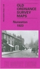
Saariselkä Kiilopää area of Finland at 1:50, 000 in a series of beautiful and informative maps of popular outdoor leisure areas with cartography of the country’s topographic survey. Excellent use of colours, shading and symbols provides a very detailed picture of the terrain and vegetation. Extensive overprint highlights routes for hiking, and/or other outdoor pursuits, a wide variety of accommodation, from hotels and holiday villages to Lapland tepees, food and fuel supplies, etc. The maps have a UTM grid and margin ticks for latitude and longitude. Map legends include English.
RIP - This product is no longer available on our network. It was last seen on 25.09.2019

This page now acts as a permanent archive for this product. Add more information using the comments box below to ensure it can still be found by future generations.

Use our search facility to see if it is available from an alternative contributor.
  • External links may include paid for promotion
  • Availability: Out Of Stock
  • Supplier: Stanfords
  • SKU: 9789522664846
Availability: In Stock
£21.99

Product Description

Saariselkä Kiilopää area of Finland at 1:50, 000 in a series of beautiful & informative maps of popular outdoor leisure areas with cartography of the country’s topographic survey. Excellent use of colours, shading & symbols provides a very detailed picture of the terrain & vegetation. Extensive overprint highlights routes for hiking, and/or other outdoor pursuits, a wide variety of accommodation, from hotels & holiday villages to Lapland tepees, food & fuel supplies, etc. The maps have a UTM grid & margin ticks for latitude & longitude. Map legends include English.

Reviews/Comments

Add New

Intelligent Comparison

Oooops!
We couldn't find anything!
Perhaps this product's unique.... Or perhaps we are still looking for comparisons!
Click to bump this page and we'll hurry up.

Price History

Vouchers

No voucher codes found.
Do you know a voucher code for this product or supplier? Add it to Insights for others to use.

Facebook

Jargon Buster

Hiking - An outdoor activity envolving walking in nature
fuel - A material used to generate energy.
Wide - Something with a large width.
Accommodation - A room in which someone can live in, for example in a hotel
Popular - Something that is admired and liked by many people.

Supplier Information

Stanfords
Stanfords was established in 1853 and opened their iconic Covent Garden flagship store in 1901. They have become the top retailer of maps, travel books and accessories in the UK and arguably offer the largest selection of maps and travel books worldwide. Famous names such as Captain Robert Falcon Scott, Ranulph Fiennes and Michael Palin have purchased from Stanfords. They now have a shop in Bristol and both stores together with other venues operate a calendar of events including talks, book signings and exhibitions. As a specialist map retailer, the map selection is comprehensive and includes road maps, street maps and walking maps from worldwide destinations, as well as a selection of world atlases and wall maps. Books include travel guides and travel literature. Stanfords also stock globes, from miniatures made of blue marble to magnificent floor-standing globes. The website features a selection of interesting articles on travel topics.
Page Updated: 2023-11-12 20:15:36

Community Generated Product Tags

Oh No! The productWIKI community hasn't generated any tags for this product yet!
Menu