More From Contributor
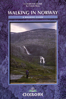
£7.99
Norway in Rick Steves' Snapshot Guides, which consist of the best chapters of Rick Steves' European country guidebooks. Published in the UK by Avalon, comprise a range of titles focussing on destinations in Great Britain & Europe. As one of the leading American guide book publishers to European destinations, Rick Steves ...
Archived Product
£12.95
Presenting 50 hikes, the Rother walking guide to Norway opens up Southern Norway between Oslo, Bergen & Lindesnes: the routes range from the highest peaks in Northern Europe, in Jotunheimen National Park, to the picturesque forests & lakes of Telemark & the high heathland areas over the waterfall-rich Setesdal valley; from the cliff scenery in Rogaland & on the glacier-covered Folgefonn peninsula, to the oases of Rondane National Park. With a selection of hikes for every physical condition, Bernhard Pollmann, one of the finest experts on Norway as a hiking paradise, describes easy & difficult routes
- family-friendly hikes are included, as are climbs up deserted peaks, challenging day-long hikes, & tours covering several days from cabin to cabin. Each route description is accompanied by colour photography, & a map at 1:50, 000 or 1:100, 000 scale. About this series: Rother Walking Guides were first published in 1920- since then Bergverlag Rother have continued to produce these comprehensive guides to
...
Archived Product
£9.50
Southern Norway at 1:500, 000 on an indexed road map with altitude colouring & prominently highlighted places of interest, printed on light, waterproof & tear-resistant paper. Published by Reise Know-How as part of their highly acclaimed World Mapping Project, the map is double-sided to provide the best balance between a good scale & a convenient size sheet. Coverage extends north to Trondheim, with a small overlap between the sides. Topography is shown by altitude colouring, with plenty of spot heights & names of mountain ranges, peaks, glaciers, fjords, etc. Road network

Includes::
small local roads & selected tracks, shows routes closed during winter, & gives driving distances on main routes. Railway lines & ferry connections are included & local airports are marked. The map also shows internal administrative boundaries & names of the provinces, as well as the boundaries of national parks. Symbols indicate various places of interest including campsites, tourist information, recreational areas, historical monuments, etc. Latitude & longitude lines are drawn at 30

...
Archived Product
£11.50
Southern Norway at 1:500, 000 on a light, waterproof & tear-resistant, indexed road map, published by Reise Know-How as part of their highly acclaimed World Mapping Project. The map is double-sided to provide the best balance between a good scale & a convenient size sheet. Coverage extends north to Trondheim, with a small overlap between the sides. Topography is shown by altitude colouring, with plenty of spot heights & names of mountain ranges, peaks, glaciers, fjords, etc. Road network

Includes::
small local roads & selected tracks, shows routes closed during winter, & gives driving distances on main routes. Railway lines & ferry connections are included & local airports are marked. The map also shows internal administrative boundaries & names of the provinces, as well as the boundaries of national parks. Symbols indicate various places of interest including campsites, tourist information, recreational areas, historical monuments, etc. Latitude & longitude lines are drawn at 30’ intervals. Map legend

Includes::
English.


...
Archived Product
£12.99
Lonely Planet Norway
Plummet down the dramatic Flamsbana railway to the breathtaking fjords below
Trace Isben's footsteps

...
Archived Product
£17.99
Topographic mapping of the Svalbard (Spitsbergen) group at 1:100, 000 is published by the Norsk Polarinstitutt in two versions. The western coast, central & southern part of Spitsbergen, plus two small islands of Svenskøya & Kongsøya, are covered by colour maps with contours at 25-metre intervals, bold relief shading, spot heights. The maps show settlements, roads & tracks, working & disused mines, airfields, lighthouses & radio beacons, etc. A grid gives UTM co-ordinates plus latitude in steps of 10` & longitude in 20’. The rest of Spitsbergen, Nordaustlandet, Edgeøya & other small islands are covered by black & white maps with contours only. Some of these maps show no geographical names. ...
Archived Product
£24.99
Svalbard (Spitsbergen) group on five topographic maps at 1:250, 000 in a new series first published by the Norsk Polarinstitutt in late 2010, with extensive index of geographical features, glossary, rules for visitors, etc. The maps provide an excellent representation of the topography, with contours at 100m intervals enhanced by relief shading & numerous spot heights, plus colouring and/or graphics for glaciers, moraine, braided rivers & flat foreshore. Boundaries of nature conservation areas are clearly marked. The map shows roads & tracks or paths, as well as airfields & heliports, power lines & aerials cableways, lighthouses & masts, working & disused mines, etc. Within the settled areas schools, churches & medical facilities are also indicated. The maps have UTM plus latitude (15’) & longitude (30’) grids. Extensive index of geographical features gives locations by latitude/longitude coordinates. On the reverse of each title are two small maps of the whole group showing magnetic declination & nature conservation areas. Another map shows the area of Spitsbergen around the Isfjorden where visitors can travel without a permit. Each map also

Includes::
a glossary of geographical terms & notes on Svalbard’s cultural heritage. Map legend & all the text include English.

...
Archived Product
£17.99
Topographic maps of the Svalbard (Spitsbergen) group from Norsk Polarinstitutt, with contours at 100m intervals. Physical features shown include moraine, rocks, coastline with flat foreshore, etc. The maps also show settlements, roads, mines, cabins, radio stations, aerial cableways, airfields, etc. National park & nature reserve boundaries are marked. The maps have a UTM grid & lines of longitude & latitude shown at 1° & 30` intervals respectively. Map legend

Includes::
English.

...
Archived Product
£18.99
Norway on regional touring maps from Cappelen presenting at 1:335, 000 the southern half of the country, with northern Norway covered at 1:400, 000/410, 000; plus towns maps and/or enlargements for popular tourist areas including Jotunheimen, the environs of Bergen, etc. Topography is presented by relief shading with numerous spot heights & names of various mountain ranges, peaks, valley, etc, plus colouring for woodlands & national parks. Road network, graded into seven types,

Includes::
selected cart tracks & indicates tolls, seasonal closures, roads closed to the public, steep gradients, etc. Driving distances are marked on main & on selected secondary roads. Also shown are selected footpaths, with some waymarked DNT (Norwegian Trekking Association) routes annotated with approximate walking times. Railways lines are shown with stations & ferry connections are marked. The maps are particularly good at highlighting accommodation facilities, with an extensive range of symbols showing hotels, motels, campsites, youth hostels, etc, indicating different standards & categories. Other symbols show places of interest, viewpoints, bird colonies, etc. Latitude & longitude lines are drawn at 15’ & 30’ respectively. There is no index of place names. Map legend

Includes::
English. The maps now also provide street plans main cities and/or detailed enlargements of popular hiking areas
- for more details please see the individual descriptions.


...
Archived Product
£10.99
Detailed, indexed touring road maps of Norway from Freytag & Berndt with plenty of tourist information. Southern Norway is shown at 1:250, 000, with the two northern sheets at 1:400, 000. Relief shading with spot heights indicates the terrain, with forested areas & natural features such as glaciers clearly marked. Road network

Includes::
private roads, toll routes, restrictions & winter closures, steep gradients, motorway service areas & accommodation, scenic routes, & intermediate driving distances on most roads. Railway network with stations & ferry connections are also marked. The maps also show large amount of tourist information: recreational facilities, places of interest, various types of accommodation, etc. Latitude & longitude grid is at intervals of 10’ on the two southern maps & 30` in northern Norway. A separate booklet attached to the map cover has an index of localities. Map legend

Includes::
English.


...
Archived Product

Norway Walking

Connie Roos’ Cicerone guide to Walking in Norway explores the best walking areas of Norway ranging from the far south to the Arctic regions. 20 walking routes are covered in total, varying in length between a few days to over a week. Norway’s landscape is ideal for walking: there are mountains relatively free from crowds and few roads criss-crossing the remote landscape. Cairned routes twist through splendid scenery and link up with comfortable mountain lodges. The walks are divided into daily segments to help walkers plan their days and supporting this is information on travelling to and within Norway, notes on what to expect in the mountains, advice on equipment to take with you and appendices detailing mountain accommodation, Norwegian vocabulary and useful addresses. Detailed
route descriptions are accompanied by line drawings mapping the route as well as black and white photographs.
RIP - This product is no longer available on our network. It was last seen on 25.09.2019

This page now acts as a permanent archive for this product. Add more information using the comments box below to ensure it can still be found by future generations.

Use our search facility to see if it is available from an alternative contributor.
  • External links may include paid for promotion
  • Availability: Out Of Stock
  • Supplier: Stanfords
  • SKU: 9781852842307
Availability: In Stock
£12.95

Product Description

Connie Roos’ Cicerone guide to Walking in Norway explores the best walking areas of Norway ranging from the far south to the Arctic regions. 20 walking routes are covered in total, varying in length between a few days to over a week. Norway’s landscape is ideal for walking: there are mountains relatively free from crowds & few roads criss-crossing the remote landscape. Cairned routes twist through splendid scenery & link up with comfortable mountain lodges. The walks are divided into daily segments to help walkers plan their days & supporting this is information on travelling to & within Norway, notes on what to expect in the mountains, advice on equipment to take with you & appendices detailing mountain accommodation, Norwegian vocabulary & useful addresses. Detailed route descriptions are accompanied by line drawings mapping the route as well as black & white photographs.

Reviews/Comments

Add New

Intelligent Comparison

Oooops!
We couldn't find anything!
Perhaps this product's unique.... Or perhaps we are still looking for comparisons!
Click to bump this page and we'll hurry up.

Price History

Vouchers

No voucher codes found.
Do you know a voucher code for this product or supplier? Add it to Insights for others to use.

Facebook

Jargon Buster

Black - A colour which does not emit any colour of the spectrum. Black absorbs all frequencies of the spectrum.
White - A colour combining all colours
Equipment - A product or good that is tactile.
Accommodation - A room in which someone can live in, for example in a hotel
Ideal - Something that satisfies a perfect criteria.
Vocabulary - The collaboration of words used in a language.

Supplier Information

Stanfords
Stanfords was established in 1853 and opened their iconic Covent Garden flagship store in 1901. They have become the top retailer of maps, travel books and accessories in the UK and arguably offer the largest selection of maps and travel books worldwide. Famous names such as Captain Robert Falcon Scott, Ranulph Fiennes and Michael Palin have purchased from Stanfords. They now have a shop in Bristol and both stores together with other venues operate a calendar of events including talks, book signings and exhibitions. As a specialist map retailer, the map selection is comprehensive and includes road maps, street maps and walking maps from worldwide destinations, as well as a selection of world atlases and wall maps. Books include travel guides and travel literature. Stanfords also stock globes, from miniatures made of blue marble to magnificent floor-standing globes. The website features a selection of interesting articles on travel topics.
Page Updated: 2023-11-12 20:15:36

Community Generated Product Tags

Oh No! The productWIKI community hasn't generated any tags for this product yet!
Menu