More From Contributor
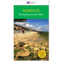
£19.95
Topographic survey of Faroe Islands at 1:20, 000 prepared by the Danish national mapping agency Kort og Matrikelstyrelsen. The islands’ topography is vividly presented by contours at 5 metre intervals, enhanced by relief shading plus colouring and/or graphics for different types of terrain or vegetation (scree, boulders, etc). The maps show all the detail expected of the topographic mapping at this scale & have a 1-km UTM grid, plus margin ticks for latitude & longitude at 1’ & 2` respectively. Map legend is in Danish only. The maps are available either separately or as sets of five of more sheets, each covering the main island group: Vagar, Sandoy, Suduroy, Nordoyar, Streymoy & Eysturoy. To see the list of all the titles in this series please click on the series link. ...
Archived Product
£23.99
Map No. 10157, Nordreisa, in the new topographic survey of Norway at 1:50, 000 covering the country on 195 double-sided sheets & first published by Nordeca in 2011
- 2012; fully GPS compatible, indicating waymarked footpaths, campsites, tourist huts, illuminated ski runs, etc. The maps, now published by Nordeca, the successors to Statens Kartverk & its subsequent owners the Ugland Group, are printed on light, waterproof & tear-resistant synthetic paper. Each map covers an area of 62x 45 kilometres (39 x 28 miles approx.), with a 2-km overlap between the sheets. The maps have contours at 20m intervals (10m glacier contours), plus colouring & graphics to show cultivated areas, bogs, forests, etc. In addition to all the information expected of topographic mapping at this scale the maps distinguish between waymarked & unmarked footpaths & show campsites, tourist huts (serviced/self service/no supplies), country hotels & restaurants, & illuminated ski trails. The series uses EUREF89 (WGS84) datum & the maps have a 1-km UTM grid. Map legend is in Norwegian & English. Each title comes in a sturdy protective card envelope.
...
Archived Product
£23.99
Nordreisa area in Norway in a series of GPS compatible recreational Turkart maps at 1:100, 000 with cartography from Norway’s topographic survey & additional tourist information. Contours lines are drawn at 20m intervals. The overprint varies from title to title, but

Includes::
local footpaths, in some cases distinguishing between easy & more difficult trails, as well as mountain huts & campsites. Many titles also indicate cycle or ski routes, other accommodation possibilities, sport & recreational facilities, including alpine skiing slopes, places of interest, etc. The maps have a UTM grid & margin ticks giving latitude & longitude. Map legend

Includes::
English. Several titles have on the reverse additional tourist information, although in most cases in Norwegian only. To see the list of Turkart maps at 1:100, 000 & links to Turkart series at 25K, 50K & Hiking Sets please click on the series link above.


...
Archived Product
£23.99
Norefjell – Eggedal area in Norway in a series of GPS compatible recreational maps at 1:50, 000 with cartography from Norway’s topographic survey & additional tourist information. Contours lines are drawn at 20m intervals. The overprint varies from title to title, but

Includes::
local footpaths, in some cases distinguishing between easy & more difficult trails, as well as mountain huts & campsites. Many titles also indicate cycle or ski routes, other accommodation possibilities, sport & recreational facilities, including alpine skiing slopes, places of interest, etc. The maps have a UTM grid & margin ticks giving latitude & longitude. Map legend

Includes::
English. Several titles have on the reverse additional tourist information, although in most cases in Norwegian only.PLEASE NOTE: this title is also available as part of a 2-map Trillemarka Hiking Set which

Includes::
the Sigdal
- Rollag map. To see the list of Turkart maps at 1:50, 000 & links to Turkart series at 25K, 100K & Hiking Sets please click on the series link above.


...
Archived Product
£5.99
Laminated waterproof folded map guide of Norfolk from Goldeneye, with a touring map on one side at 1:126, 720, & tourist information on the reverse. Cartography shows A & B, & minor roads, as well as railway lines & stops. Topography is shown through altitude colouring at intervals of 250feet, & spot heights. Points of interest & local facilities are prominently highlighted, such as castles, museums, accommodation, parking, & more. Towns & villages are indexed. The reverse has an introduction to Norfolk, followed by recommended places to visit, with some arranged by particular interest, including Arts & Crafts, Wildlife, Historical, Theaters, & Visitor Centres. ...
Archived Product
£5.95
Norfolk in a series of colourful reproductions of attractive county maps by John Speede from about 1610-1611, printed on thick art paper & ideal for framing. Each title, 58 x 45cm / approx. 23” x 18”, is decorated with additional notes, drawings, coats of arms, street plans, etc. Little drawings are used to show locations of towns, larger villages, hills & woodlands or parks. Rivers & lakes are also drawn, as are boundaries of the administrative subdivisions with the names of the Hundreds. Surrounding the county are decorative panels filled with additional information which differs from title to title: street plans, coats of arms of notable local families, geographical features, notes about local history, etc. ...
Archived Product
£12.99
With landscapes that stretch as far as the eye can see, the counties of Norfolk & Suffolk, & the countryside around Cambridge, are some of the most enchanting places to visit anywhere in Engl&. The AA Guide to Norfolk & Suffolk gives you all you need to know to get the most out of your visit to this wonderful area. From Constable country to the north Norfolk coastline, the ` Backs` of Cambridge to the `gallops` of Newmarket, each entry is packed with the very best sites to see, things to do, recommendations for eating & drinking, & places to explore nearby. With everything from local legends to must-see festivals & events, this authoritative & practical guide ensures you will never be lost for something to do. ...
Archived Product
£12.99
The Time Out Guide to Norfolk & Suffolk explores a range of things to do & see in England’s East Anglia & incorporates cultural events, local attractions, recommended pubs & restaurants, outdoor activities, local villages & towns & is suitable for residents, regular visitors or those new to the region. One of the few guides dedicated to Norfolk & Suffolk, the guide is organised locally by destination, allowing a comprehensive amount of detail on each local area. Time Out guides are strongly focussed on local entertainment & nightlife, in addition to principal sights & attractions, with expert local writers providing an encyclopaedic knowledge of the area. This unique quality has ensured that the guides have won a reputation for their accuracy & reliability. Each section is organised similarly, allowing readers to access the information they need easily. An overview of the area, including local towns, village & countryside of note is provided, with further sections dedicated to where to stay, eat & drink, places to visit & things to do. Thematic indexes for each county are also provided. ...
Archived Product
£11.99
With landscapes that stretch as far as the eye can see, the counties of Norfolk & Suffolk, & the countryside around Cambridge, are some of the most enchanting places to visit anywhere in Engl&. The AA Guide to Norfolk & Suffolk gives you all you need to know to get the most out of your visit to this wonderful area. From Constable country to the north Norfolk coastline, the ' Backs' of Cambridge to the 'gallops' of Newmarket, each entry is packed with the very best sites to see, things to do, recommendations for eating & drinking, & places to explore nearby. With everything from local legends to must-see festivals & events, this authoritative & practical guide ensures you will never be lost for something to do. ...
Archived Product
£12.99
This new, thoroughly updated second edition of Bradt`s Norfolk, part of the distinctive ` Slow travel` series of guides to UK regions, remains the only full-blown standalone guide available to this county of contrasts, from the fine medieval city of Norwich to the watery wilderness of the Broads & the sweeping beaches of the superlative north Norfolk coast. As well as featuring all the main sights, Bradt`s Norfolk covers places & aspects of the region not detailed by other guidebooks & has a special emphasis on car-free travel, walking, local food & pubs. It also

Includes::
personal anecdotes & the views of local people as well as tapping into the Norfolk-based author`s considerable knowledge of the region. Making a virtue of being selective, the guide points visitors to the cream of the area, but

Includes::
the whole of Norfolk from Great Yarmouth & the Broads in the east to the Fens of the far west, from the iconic north Norfolk coast to the Breckland region to the south. Places to eat & drink are selected by the author based upon long-standing knowledge of the area, in particular delving into aspects of local distinctiveness & character. Flora & fauna are also covered, detailing the many wildlife sites within the county that are home to rare species, including the iconic Swallowtail butterfly, & information is provided on many of the best birdwatching spots. Hiking & biking, literary & artistic connections, canoeing & water-based activities, local food & drink, & all the practical information you could need are included, helping to make this the must-have guide for all visitors to this beguiling county. Written in an entertaining style combining personal narrative with authoritative information, Bradt`s Norfolk has all the most up-to-date information you could need for a successful visit.


...
Archived Product

Norfolk

Pathfinder(R) Norfolk covering Castle Rising, Oxburgh Hall and Overstrand. This selection offers interest, regional variety and balance of routes in Norfolk providing the best walks in the area. From an easy stroll in Tyrrel`s Wood to the much more challenging walk in Fordham this volume contains something for everyone. Covering walks through the whole of Norfolk both popular and little know scenic routes including Wells-next-the-Sea, Peddars Way and Binham. -See walk locations by Looking Inside Inside: -28 great walks in Norfolk from 2 to 10 miles -Clear, large scale Ordnance Survey route maps -GPS reference for all Norfolk waypoints -Where to park, good pubs and places of interest en route -All routes have been fully researched and written by expert outdoor writers -Beautiful
photography of scenes from the walks Pathfinder(R) Guides are Britain`s best loved walking guides. Made with durable covers, they are the perfect companion for countryside walks throughout Britain. Each title features circular walks with easy-to-follow route descriptions, large-scale Ordnance Survey route maps and GPS waypoints.With over 70 titles in the series, they offer essential information for walkers throughout the country.Contents* Horsey* Binham Priory* Oxborough and Gooderstone* Hales Green from Loddon* Marham Fen and the Nar Valley Way* Tyrrel`s Wood and Shelton* Felbrigg Park and Metton* Langmere and the Devil`s Punchbowl* River Bure and Upton Marshes* How Hill and Ludham* The Buckenhams* Hardley Cross* Blickling and the River Bure* Peddars Way - Fring and Sedgeford* Castle
Acre and West Acre* Boudica`s Way - Shotesham and Saxlingham Nethergate* Thompson Common and the Pingos* Westwick Woods and the Weavers Way* West Runton and Beacon Hill* Wiveton Downs and Cley next the Sea* The Burnhams* Denver Sluice - a three rivers walk* Wells-next-the-Sea, Warham and Wighton* Weavers Way to the Berney Arms* Reepham, Marriott`s Way and Salle* Weeting Castle and Grime`s Graves* Castle Rising and Roydon Common* Ringstead Downs and the Norfolk Coast
RIP - This product is no longer available on our network. It was last seen on 25.09.2019

This page now acts as a permanent archive for this product. Add more information using the comments box below to ensure it can still be found by future generations.

Use our search facility to see if it is available from an alternative contributor.
  • External links may include paid for promotion
  • Availability: Out Of Stock
  • Supplier: Stanfords
  • SKU: 9780319090152
Availability: In Stock
£12.99

Product Description

Pathfinder (R) Norfolk covering Castle Rising, Oxburgh Hall & Overstr&. This selection offers interest, regional variety & balance of routes in Norfolk providing the best walks in the area. From an easy stroll in Tyrrel`s Wood to the much more challenging walk in Fordham this volume contains something for everyone. Covering walks through the whole of Norfolk both popular & little know scenic routes including Wells-next-the-Sea, Peddars Way & Binham. -See walk locations by Looking Inside Inside: -28 great walks in Norfolk from 2 to 10 miles -Clear, large scale Ordnance Survey route maps -GPS reference for all Norfolk waypoints -Where to park, good pubs & places of interest en route -All routes have been fully researched & written by expert outdoor writers -Beautiful photography of scenes from the walks Pathfinder (R) Guides are Britain`s best loved walking guides. Made with durable covers, they are the perfect companion for countryside walks throughout Britain. Each title features circular walks with easy-to-follow route descriptions, large-scale Ordnance Survey route maps & GPS waypoints. With over 70 titles in the series, they offer essential information for walkers throughout the country. Contents* Horsey* Binham Priory* Oxborough & Gooderstone* Hales Green from Loddon* Marham Fen & the Nar Valley Way* Tyrrel`s Wood & Shelton* Felbrigg Park & Metton* Langmere & the Devil`s Punchbowl* River Bure & Upton Marshes* How Hill & Ludham* The Buckenhams* Hardley Cross* Blickling & the River Bure* Peddars Way
- Fring & Sedgeford* Castle Acre & West Acre* Boudica`s Way
- Shotesham & Saxlingham Nethergate* Thompson Common & the Pingos* Westwick Woods & the Weavers Way* West Runton & Beacon Hill* Wiveton Downs & Cley next the Sea* The Burnhams* Denver Sluice
- a three rivers walk* Wells-next-the-Sea, Warham & Wighton* Weavers Way to the Berney Arms* Reepham, Marriott`s Way & Salle* Weeting Castle & Grime`s Graves* Castle Rising & Roydon Common* Ringstead Downs & the Norfolk Coast

Reviews/Comments

Add New

Intelligent Comparison

Oooops!
We couldn't find anything!
Perhaps this product's unique.... Or perhaps we are still looking for comparisons!
Click to bump this page and we'll hurry up.

Price History

Vouchers

No voucher codes found.
Do you know a voucher code for this product or supplier? Add it to Insights for others to use.

Facebook

Jargon Buster

GPS - Global Positioning System - Global position using satellites
Wood - A hard material found in trees. Used for tool making, fuel and construction.
Large - something that takes up more space than normal.
Balance - Something that is evenly weighted to keep something upright.
Hall - A room at the inside of an entrance of a house.
Popular - Something that is admired and liked by many people.
Regional - An adjective to describe a set geographic area.
Reference - To prove evidence with a back up source.

Supplier Information

Stanfords
Stanfords was established in 1853 and opened their iconic Covent Garden flagship store in 1901. They have become the top retailer of maps, travel books and accessories in the UK and arguably offer the largest selection of maps and travel books worldwide. Famous names such as Captain Robert Falcon Scott, Ranulph Fiennes and Michael Palin have purchased from Stanfords. They now have a shop in Bristol and both stores together with other venues operate a calendar of events including talks, book signings and exhibitions. As a specialist map retailer, the map selection is comprehensive and includes road maps, street maps and walking maps from worldwide destinations, as well as a selection of world atlases and wall maps. Books include travel guides and travel literature. Stanfords also stock globes, from miniatures made of blue marble to magnificent floor-standing globes. The website features a selection of interesting articles on travel topics.
Page Updated: 2023-11-12 20:15:36

Community Generated Product Tags

Oh No! The productWIKI community hasn't generated any tags for this product yet!
Menu