More From Contributor
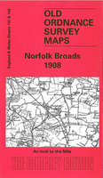
£11.95
A full account of the part played by Norfolk`s airfields during the Second World War. The history of each airfield is described with the squadrons & aircraft based at them & the main operations flown. The effects of the war on the daily lives of civilians, & the constant dangers from raids & night bombing are also detailed. Fully illustrated. ...
Archived Product
£12.99
Norfolk & Suffolk in the Countries, Regions & Cities series from Rough Guides; comprehensively detailed guidebooks specifically designed for independent travellers & serving a range of worldwide destinations. Widely recognised for their free editorial style, Rough Guide authors are allowed to express their personal opinions on a range of subjects. Although sometimes controversial, this editorial stance allows readers to experience more detailed & personal takes on each destination, a feature often more limited in other guidebooks. Cultural & historical nuances are explored in significant depth throughout the text & descriptions on the ambience of individual settings alongside personal recommendations, particularly in cities, are notably prevalent. Each Rough Guide in the Countries, Regions & Cities series has a similar layout. A ...
Archived Product
£12.99
Wild, untamed seascapes, shifting coastlines, freshly caught seafood on Blue-Flag beaches, meandering waterways, Constable countryside, grassy heathl&, ruined abbeys & riverside hamlets
- East Anglia is an area that has been gaining in popularity as a UK holiday destination for some time: from the small but bustling cities of Cambridge & Norwich, to the pretty market towns of Woodbridge & Lavenham, & the world famous waterways of the Norfolk & Suffolk Broads, East Anglia offers stunning scenery, great local produce & fascinating history. Best of Britain: Norfolk & Suffolk provides visitors with local information from the locals themselves, to source the best-kept secrets of the region. The guide also

Includes::
practical information on a range of accommodation, the best places to eat, local festivals, events & activities as well as informing readers about the history, geology & culture of the area. Informative maps are found throughout the book, including walking & climbing routes & children`s activities in the area. Discover the world`s smallest pub in Bury St Edmunds, take part in the world-renowned international crabbing championships in Walberswick, explore the coastal town of Dunwich that is gradually disappearing into the sea & enjoy some of the most beautiful & unspoiled beaches on the British coastline. Best of Britain: Norfolk & Suffolk saves you precious holiday time by hand selecting: The best...fresh, organic & local produce, & the best tucked-away farm shops & delis to buy it from. The best...places to eat out: from quirky cafes to Michelin-starred restaurants. The best...wet-weather options: for when the unpredictable British weather lets you down. The best...things to do with children (and where to go to get away from them!)
  • The best...places to stay: from cosy cottages to boutique hotels
  • The best...local legends, festivals & pubs
    • Want to explore more of the Best of Britain? Why not check out some of the other titles in the Best of Britain series: Cornwall... Cotswolds... Devon... East Anglia... Edinburgh & East Coast Scotl&... Isle of Wight & the New Forest... Lake District & Peak District


    ...
    Archived Product
    £7.99
    Ideal for on-the-spot use, Great Breaks Norfolk & Suffolk makes the perfect companion for both first-time & repeat visitors. The Top 10 section is designed to help you get the most out of your trip, highlighting the best the region has to offer, from majestic cathedrals & steam railways to nature reserves. Carefully planned walks & tours take you on a journey through picturesque villages & charming seaside towns, past medieval churches & the tranquil beauty of the Norfolk Broads. The guide also features excursions to the historic city of Cambridge & Constable Country in Essex. All routes are timed & accompanied by easy-to-follow maps with detailed information on transport & where to find the best locally produced food, plus fascinating facts & tips. Accommodation listings cover everything from family-friendly B& Bs & self-catering cottages to stylish boutique hotels. Containing beautiful full-colour photography & invaluable information, Great Breaks Norfolk & Suffolk is the perfect companion for any visitor to this delightful part of Engl&. ...
    Archived Product
    £9.99
    Norfolk Broads Waterways Guide published by Collins under their Nicholson imprint in a series of spiral-bound guides to Britain’s inland waterways. The guide covers the Broads National Park, including the Norfolk & Suffolk Broads, & the rivers Waveney, Yare, Bure, Ant, Thurne & Chet. The Norfolk Broads guide has a much bigger introductory section than other guides in this series, &

    Includes::
    several pages of notes on the fauna & flora illustrated with colour photos, Guides in the Nicholson series have Ordnance Survey’s mapping from the Landranger series with an overprint highlighting the waterways & adding locks with their names, number & rise, also staircase locks, weirs, turning points, various facilities such as overnight moorings, water points, sewage & refuse disposal, food shops, public houses & restaurants, etc. Towpaths, which can also be used by hikers or cyclists, are clearly marked. The guides provide descriptions of towns & villages, contact details & where appropriate opening hours of local services, etc. Each guide also

    Includes::
    an introductory section with general advice, regulations & tips. Completing the series is a general map of Great Britain showing the country’s navigable waterways.


    ...
    Archived Product
    £7.99
    The Norfolk Broads at 1:25, 000 in a series of Walker’s Maps published by the AA with the cartography from the Ordnance Survey’s Explorer series. The map is double-sided & coverage

    Includes::
    Great Yarmouth, Ormesby St Margaret, Caister-on-Sea, Hordey, Sea Palling, Catfield, Wroxham, Thorpe End, Brundall, Yelverton, Brooke, Ellingham, Earcham, Beccles, Lowestoft, Hopton-on-Sea, etc. Maps in the AA Walker’s series are identical to the OS Explorer maps & provide plenty of recreational & tourist information, indicating in England & Wales the traditional public rights of way paths, including bridleways & byways restricted or open to motorized traffic. Also shown are other routes with public access, including permissive footpaths & bridleways. For Scotl&, where different access rights apply, the maps provide an additional note explaining the regulations. Special marking indicates National Trails & Recreational Routes & for cyclists the maps show traffic-free routes & the National Cycle Network. A wide range of symbols highlights locations of special tourist interest: camping & caravanning sites, youth hostels, information offices & visitors’ centres, parking & picnicking places, historic buildings (indicating where appropriate National Trust, English Heritage, Historic Scotland or Cadw), sites for various recreational pursuits, country pubs, public toilets, etc. The maps provide detailed presentation of the topography with contours at 5 or 10m intervals, numerous spot heights & colouring and/or graphics for different types of vegetation. Additional colouring shows access l&, including areas managed by the National Trust, Forestry Commission & Woodland Trust. All the standard information expected of high quality survey mapping at this scale is included: finely graded road network, railway lines with stations, cuttings or embankments, individual isolated buildings, etc. For GPS users the British National Grid is drawn at 1km intervals.

    ...
    Archived Product
    £14.99
    The Norfolk Broads is a unique wetland environment, with marvellous wildlife & scenery that is ideal for exploring by canoe or kayak. This guide provides all the information you need to plan your journey through this picturesque landscape. Seven rivers & fourteen Broads are described in detail, with information on launching points, local attractions, wildlife & history. Distances between launching points are also provided, along with details of riverside campsites & pubs, enabling you to plan single & multi-day trips. To help you prepare for your journey there is also advice on tides, safety, access & environmental issues. ...
    Archived Product
    £6.39
    A detailed topographic map of Norfolk Coast Central from the Ordnance Survey Explorer series, covering Wells-next-the-Sea & Fakenham. Edition A4; Publication date January 2012 About this series: These highly detailed maps show all the administrative boundaries, settlements as small as isolated farms, the road network down to unfenced roads & country tracks, & field boundaries (hedges & drystone walls) which make navigation across the countryside much easier. Steep gradients on roads are indicated. Various landmarks, e.g. powerlines, archaeological sites, windmills, churches & lighthouses are shown & additional graphics indicate natural terrain features such as cliffs, scree, mud & vegetation variations. The contour interval is 5 metres in the lower parts of the country & 10 metres in the uplands, & spot heights are marked. Each map covers an area of 30 x 20km (i.e. approx. 19 x 12 miles), with some double-sided maps covering more, as indicated in the individual descriptions. The maps are fully GPS compatible, with the National Grid shown at 1km intervals & latitude & longitude indicated by margin ticks at 1'. The Explorer series has replaced the earlier, green-cover Pathfinder maps. The Explorer series is now complete & covers all of Engl&, Wales & Scotl&. Some sheets for popular areas like the National Parks are still branded as Outdoor Leisure (OL) maps, but are now included in this series as the cartography is the same as that in the Explorer Maps. The Explorer maps offer a substantial improvement on the Pathfinder series, with greater use of colour, larger area per map, & stronger emphasis on information for ramblers & tourists. This series is ideal for walking & other outdoor pursuits & each map shows a large amount of information for ramblers & tourists. Public rights of way are shown (except in Scotland), together with other routes with public access: National Trails & Recreational Paths, permitted paths & bridleways, & selected cycle routes. Open access land created under the Countryside & Rights of Way Act 2000 is marked. Tourist information

    Includes::
    caravan & camp sites, Park & Ride locations, recreation/leisure/sport centres, museums, historic buildings, English Heritage & National Trust sites, rural pubs, etc. The map legend is in English only, except for the tourist information content which is also in French & German.

    ...
    Archived Product
    £14.99
    Norfolk Coast Central, Wells-next-the-Sea & Fakenham area on a detailed topographic & GPS compatible map No. 251, waterproof version, from the Ordnance Survey’s 1:25, 000 Explorer series.MOBILE DOWNLOADS: this title & all the other OS Explorer maps include a code for downloading after purchase the digital version onto your smartphone or tablet for viewing on the OS smartphone app.OS EXPLORER SERIES: to see the list of all the titles in the OS Explorer series, both paper & waterproof versions, please click on the series link. The Explorer series, Ordnance Survey’s most detailed maps recommended for anyone enjoying outdoor activities, provides topographic coverage of Great Britain at 1:25, 000 on GPS compatible maps with hiking trails, cycling routes & extensive tourist information. Each printed map is available either on paper or as a waterproof & tear-resistant OS Active Map, as indicated in its title. Britain’s National Parks & other areas of particular tourist interest are presented on often double-sided OL (Outdoor Leisure) maps, whilst most standard format Explorers cover an area of 30 x 20km (approx. 19 x 12 miles). All three versions (paper, waterproof & digital) are the same & provide plenty of recreational & tourist information, indicating the traditional public right of way paths (except in Scotland where different laws apply), including bridleways & byways. National Trails & other long-distance paths are marked, as well as permissive footpaths or bridleways & on-road or traffic-free cycle routes with, where appropriate, their National/ Regional Cycle Network numbers. Boundaries of access land are clearly marked. A wide range of symbols provides additional tourist information, highlighting camping & caravanning sites, information offices & visitors’ centres, parking & picnicking places, country pubs, sport & recreational facilities including cycle hire locations & mountain biking trails, historic buildings & museums, etc. Exceptionally clear presentation of the landscape is provided by contours at 5m or in the uplands at 10m intervals, with additional spot heights plus colouring and/or graphics for different types of woodlands, orchards, heath, marshl&, scree or boulders, & other topographic features. For GPS users the maps have British National Grid lines at 1km intervals, with latitude & longitude given by margin ticks at 1`. Clearly laid out map legend

    Includes::
    French & German translations for the tourist information symbols.

    ...
    Archived Product
    £8.99
    Norfolk Coast Central, Wells-next-the-Sea & Fakenham area on a detailed topographic & GPS compatible map No. 251, paper version, from the Ordnance Survey’s 1:25, 000 Explorer series.MOBILE DOWNLOADS: this title & all the other OS Explorer maps include a code for downloading after purchase the digital version onto your smartphone or tablet for viewing on the OS smartphone app.OS EXPLORER SERIES: to see the list of all the titles in the OS Explorer series, both paper & waterproof versions, please click on the series link. The Explorer series, Ordnance Survey’s most detailed maps recommended for anyone enjoying outdoor activities, provides topographic coverage of Great Britain at 1:25, 000 on GPS compatible maps with hiking trails, cycling routes & extensive tourist information. Each printed map is available either on paper or as a waterproof & tear-resistant OS Active Map, as indicated in its title. Britain’s National Parks & other areas of particular tourist interest are presented on often double-sided OL (Outdoor Leisure) maps, whilst most standard format Explorers cover an area of 30 x 20km (approx. 19 x 12 miles). All three versions (paper, waterproof & digital) are the same & provide plenty of recreational & tourist information, indicating the traditional public right of way paths (except in Scotland where different laws apply), including bridleways & byways. National Trails & other long-distance paths are marked, as well as permissive footpaths or bridleways & on-road or traffic-free cycle routes with, where appropriate, their National/ Regional Cycle Network numbers. Boundaries of access land are clearly marked. A wide range of symbols provides additional tourist information, highlighting camping & caravanning sites, information offices & visitors’ centres, parking & picnicking places, country pubs, sport & recreational facilities including cycle hire locations & mountain biking trails, historic buildings & museums, etc. Exceptionally clear presentation of the landscape is provided by contours at 5m or in the uplands at 10m intervals, with additional spot heights plus colouring and/or graphics for different types of woodlands, orchards, heath, marshl&, scree or boulders, & other topographic features. For GPS users the maps have British National Grid lines at 1km intervals, with latitude & longitude given by margin ticks at 1`. Clearly laid out map legend

    Includes::
    French & German translations for the tourist information symbols.

    ...
    Archived Product

    Norfolk Broads 1908

    Norfolk Broads in 1908 in a series of reproductions of Ordnance Survey’s famous ”Inch to the Mile” maps published in the Alan Godfrey Editions to provide a historical record of England and Wales in the second half of 19th and early 20th century.In this title coverage stretches from North Walsham and Belaugh eastward to the coast and out to the Cockle Lightship; and from Mundesley southward to Woodbastwick. Features include the River Thurne, Ranworth Broad, Wroxham Broad, Ormesby Broad, Hickling Broad, Heighton Sound, Burton Broad; also the Midland & Great Northern Joint Railway. Other locations shown on the map include Ashmanhaugh, Bacton, Barton Turf, Beeston St Lawrence, Brumstead, Catfield, Clippesby, Crostwright, Dilham, East Ruston, East Somerton, Edingthorpe,
    Gimingham, Happisburgh, Hemsby, Hickling, Honing, Horning, Horsey, Hoveton St John, Hoveton St Peter, Ingham, Irstead, Knapton, Lessingham, Ludham, Martham, Neatishead, Ormesby St Michael, Ormesby St Margaret with Scratby, Palling, Paston, Potter Heigham, Rackheath, Ridlington, Rollesby, Salhouse, Sco Ruston, Sloley, Smallburgh, Stalham, Swafield, Thurne, Trunch, Tunstead, Walcott, Waxham, West Somerton, Westwick, Witton, Worstead and Wroxham. On the reverse is a more detailed map of the seaside village of Winterton, plus a directory.About the Alan Godfrey Editions of the OS Inch to the Mile Maps: the maps provide an invaluable overview of a wider area, typically 18 x 12 miles (29 x 19 kms approx.), and offer historical mapping for small towns and
    villages not covered by the more detailed series for which the Godfrey Editions are better known. On the reverse all the maps have historical notes and most titles also include a more detailed, large scale map of a small town or a village in the area.To see other titles in this series please click on the series link.
    RIP - This product is no longer available on our network. It was last seen on 25.09.2019

    This page now acts as a permanent archive for this product. Add more information using the comments box below to ensure it can still be found by future generations.

    Use our search facility to see if it is available from an alternative contributor.
    • External links may include paid for promotion
    • Availability: Out Of Stock
    • Supplier: Stanfords
    • SKU: 9781841515762
    Availability: In Stock
    £3.50

    Product Description

    Norfolk Broads in 1908 in a series of reproductions of Ordnance Survey’s famous ” Inch to the Mile” maps published in the Alan Godfrey Editions to provide a historical record of England & Wales in the second half of 19th & early 20th century. In this title coverage stretches from North Walsham & Belaugh eastward to the coast & out to the Cockle Lightship; & from Mundesley southward to Woodbastwick. Features include the River Thurne, Ranworth Broad, Wroxham Broad, Ormesby Broad, Hickling Broad, Heighton Sound, Burton Broad; also the Midland & Great Northern Joint Railway. Other locations shown on the map include Ashmanhaugh, Bacton, Barton Turf, Beeston St Lawrence, Brumstead, Catfield, Clippesby, Crostwright, Dilham, East Ruston, East Somerton, Edingthorpe, Gimingham, Happisburgh, Hemsby, Hickling, Honing, Horning, Horsey, Hoveton St John, Hoveton St Peter, Ingham, Irstead, Knapton, Lessingham, Ludham, Martham, Neatishead, Ormesby St Michael, Ormesby St Margaret with Scratby, Palling, Paston, Potter Heigham, Rackheath, Ridlington, Rollesby, Salhouse, Sco Ruston, Sloley, Smallburgh, Stalham, Swafield, Thurne, Trunch, Tunstead, Walcott, Waxham, West Somerton, Westwick, Witton, Worstead & Wroxham. On the reverse is a more detailed map of the seaside village of Winterton, plus a directory. About the Alan Godfrey Editions of the OS Inch to the Mile Maps: the maps provide an invaluable overview of a wider area, typically 18 x 12 miles (29 x 19 kms approx.), & offer historical mapping for small towns & villages not covered by the more detailed series for which the Godfrey Editions are better known. On the reverse all the maps have historical notes & most titles also include a more detailed, large scale map of a small town or a village in the area. To see other titles in this series please click on the series link.

    Reviews/Comments

    Add New

    Intelligent Comparison

    Oooops!
    We couldn't find anything!
    Perhaps this product's unique.... Or perhaps we are still looking for comparisons!
    Click to bump this page and we'll hurry up.

    Price History

    Vouchers

    No voucher codes found.
    Do you know a voucher code for this product or supplier? Add it to Insights for others to use.

    Facebook

    Jargon Buster

    Inch - Equivalent to approximately 2.5cm
    England - A country within the United Kingdom.
    honing - A process for final surface finishing. Abrasive stones are used to remove minute amounts of material from a surface.
    Large - something that takes up more space than normal.
    Small - something that takes up less space than normal.
    Invaluable - Something that cannot be replaces as it is indispensable.

    Supplier Information

    Stanfords
    Stanfords was established in 1853 and opened their iconic Covent Garden flagship store in 1901. They have become the top retailer of maps, travel books and accessories in the UK and arguably offer the largest selection of maps and travel books worldwide. Famous names such as Captain Robert Falcon Scott, Ranulph Fiennes and Michael Palin have purchased from Stanfords. They now have a shop in Bristol and both stores together with other venues operate a calendar of events including talks, book signings and exhibitions. As a specialist map retailer, the map selection is comprehensive and includes road maps, street maps and walking maps from worldwide destinations, as well as a selection of world atlases and wall maps. Books include travel guides and travel literature. Stanfords also stock globes, from miniatures made of blue marble to magnificent floor-standing globes. The website features a selection of interesting articles on travel topics.
    Page Updated: 2023-11-12 20:15:36

    Community Generated Product Tags

    Oh No! The productWIKI community hasn't generated any tags for this product yet!
    Menu