
 United Kingdom
 France
 Germany
 Netherlands
 Sweden
 USA
USA
 Italy
Italy
 Spain
Spain
More From Contributor


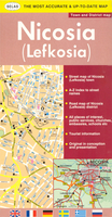
Nicosia
Nicosia (Lefkosia) street plan at 1:11, 000 from the locally based Selas Publications, with an extensive index plus lists of various government offices, public building and services, cultural and educational institutions, selected hotels, youth hostels, embassies, etc. (with their names in English). Main traffic arteries are highlighted; one way streets and locations of petrol stations are marked. Various places of interest, services and institutions are indicated. All place names are in the Latin alphabet only. No street names are given in the Turkish zone, including its part of the Old Town. Map legend includes English. Street index is on the reverse; the lists of institutions, etc. are next to the map.Also provided is a road map of the Nicosia district, including access to
the Troodos Mountains.
the Troodos Mountains.

Product Description
Reviews/Comments
Add New
Intelligent Comparison
Archived Product
Nilsia Stanfords
£17.99
Archived Product

Nisa Stanfords
£17.99
Archived Product
Nisa Stanfords
£17.99
Vouchers
No voucher codes found.
Do you know a voucher code for this product or supplier? Add it to Insights for others to use.
Do you know a voucher code for this product or supplier? Add it to Insights for others to use.
 Denmark