
 United Kingdom
 France
 Germany
 Netherlands
 Sweden
 USA
USA
 Italy
Italy
 Spain
Spain
More From Contributor

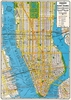


New York In 3-D (folded Version)
Nostalgic view of central Manhattan from Bollman Verlag, on a beautiful panorama map presenting this part of New York in 3-D as it was in the 1980s, with all the buildings drawn with full architectural detail, from the tops of the Empire State or Chrysler sky scrapers to less famous apartment blocks, squares and parks.The map covers central Manhattan from the Hudson to the East River, with the 42nd Street running diagonally across it. Coverage north/south is approximately from the Lincoln Centre to Madison Square.On the reverse is a conventional plan providing an overview of most of Manhattan, southern Bronx, Queens and northern Brooklyn, overprinted with subway lines with stations. The map is accompanied by a booklet with the city
Product Description
Reviews/Comments
Add New
Vouchers
No voucher codes found.
Do you know a voucher code for this product or supplier? Add it to Insights for others to use.
Do you know a voucher code for this product or supplier? Add it to Insights for others to use.
 Denmark