
 United Kingdom
 France
 Germany
 Netherlands
 Sweden
 USA
USA
 Italy
Italy
 Spain
Spain
More From Contributor


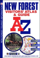
New Forest A-Z Visitors` Atlas & Guide
New Forest Visitors’ Atlas from Geographers` A-Z Map Company with a guide to places of interest, including lists of caravan and camping sites, pubs and inns, tea rooms and cafes, etc, plus street plans of the region’s main towns.The atlas, part of the publishers’ series of detailed Visitors’ road maps and/or road atlases of popular holiday areas of England has mapping at 1:42, 240 (1.5” to 1 mile) which prominently highlights a wide range of local facilities and places of interest including tourist information centres, pubs, cafes and tea rooms, picnic sites, cycle hire, nature reserves and bird sanctuaries, etc. Clearly presented road network indicates driving distances on A and B roads, locations of speed cameras and petrol stations. The maps also show local paths
and cycle routes. Each page has the British National Grid lines.27 indexed street plans, also annotated with places of interest, present local towns including central Southampton. For each location the atlas provides a brief history, descriptions of places of interest and a list of facilities with contact details. A separate 10-page guide section covers other attractions of the region. Also provided are lists with contact details of leisure facilities, shopping, fuel stations, cycle hire, pubs and inns, tea rooms/coffee shops/cafes, and caravan and camping sites.
and cycle routes. Each page has the British National Grid lines.27 indexed street plans, also annotated with places of interest, present local towns including central Southampton. For each location the atlas provides a brief history, descriptions of places of interest and a list of facilities with contact details. A separate 10-page guide section covers other attractions of the region. Also provided are lists with contact details of leisure facilities, shopping, fuel stations, cycle hire, pubs and inns, tea rooms/coffee shops/cafes, and caravan and camping sites.

Product Description
Reviews/Comments
Add New
Vouchers
No voucher codes found.
Do you know a voucher code for this product or supplier? Add it to Insights for others to use.
Do you know a voucher code for this product or supplier? Add it to Insights for others to use.
 Denmark