
 United Kingdom
 France
 Germany
 Netherlands
 Sweden
 USA
USA
 Italy
Italy
 Spain
Spain
More From Contributor


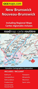
New Brunswick
Indexed road map of New Brunswick at 1:600, 000 with coverage of much of Nova Scotia and Price Edward Island, with more detailed maps of Saint John, Edmundston, Fredericton, Moncton, Campbellton, Bathurst, Hampton Grand Galls / Grand-Sault, and Miramichi, plus ferry information and a distance chart. The whole province is shown on one side at 1:600, 000, with coverage of Nova Scotia extending east to New Glasgow and south to Halifax, plus the western half of Prince Edward Island. Topography is indicated by colouring for national/provincial parks and other protected areas, with numerous small rivers named on the map. Road network indicates paved, loose surface or unimproved roads, and shows driving distances on main routes. Locations with scheduled air service and ferry
connections are marked. Symbols show campsites, visitor information centre, ski areas and various places of interest. No geographical coordinates are provided; the index is next to the map.The environs of main towns are presented in greater detail on panels at scales from 1:50, 000 to 1:100, 000. The map also includes a list of ferry operators with contact details, plus a distance table.To see the list of currently available Canadian province and regional maps form the MapArt / Canadian Cartographics Corporation / JDM Géo publishing group, including waterproof and tear-resistant FastTrack titles, please click on the series link.
connections are marked. Symbols show campsites, visitor information centre, ski areas and various places of interest. No geographical coordinates are provided; the index is next to the map.The environs of main towns are presented in greater detail on panels at scales from 1:50, 000 to 1:100, 000. The map also includes a list of ferry operators with contact details, plus a distance table.To see the list of currently available Canadian province and regional maps form the MapArt / Canadian Cartographics Corporation / JDM Géo publishing group, including waterproof and tear-resistant FastTrack titles, please click on the series link.

Product Description
Reviews/Comments
Add New
Vouchers
No voucher codes found.
Do you know a voucher code for this product or supplier? Add it to Insights for others to use.
Do you know a voucher code for this product or supplier? Add it to Insights for others to use.
 Denmark