
 United Kingdom
 France
 Germany
 Netherlands
 Sweden
 USA
USA
 Italy
Italy
 Spain
Spain
More From Contributor


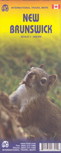
New Brunswick ITMB
Double-sided map of New Bruswick, part of a series of maps of Canadian provinces from the Vancouver-based ITMB, with topography presented by altitude colouring rather than by relief shading, with spot heights in feet.The map divides New Brunswick north/south, with a good overlap between the sides. Roads, railways and ferry connections are shown, including border crossings to Maine, with locations of visitors centres prominently highlighted. Other symbols mark national and provincial parks or protected areas, historic sites and museums, ski areas, fishing sites, golf courses, etc. The map has a latitude and longitude margin ticks at intervals of 30’ and an index of localities.

Product Description
Reviews/Comments
Add New
Intelligent Comparison
Archived Product
New Brunswick Stanfords
£8.99
Vouchers
No voucher codes found.
Do you know a voucher code for this product or supplier? Add it to Insights for others to use.
Do you know a voucher code for this product or supplier? Add it to Insights for others to use.
 Denmark