More From Contributor
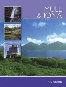
£8.50
Street plan of Le Mans, part of an extensive series covering French cities & towns from Blay-Foldex, the country’s largest, oldest & most experienced publisher of urban mapping. Blay plans include outer suburbs &, where appropriate, adjoining localities forming part of the urban agglomeration & provide brief descriptions of the town’s main sights, contact details for hotels & other places of interest, etc. The plans show one way streets, car parks & pedestrian zones. Important public buildings are clearly marked & identified. Blay street maps are usually double-sided & include an enlargement for the town centre & a street index with separate lists of “edifices publics”: main public buildings, places of worship, schools, sport facilities, stations, etc. Each of the outer suburbs or the adjoining localities, identified with its postcode, has a separate index. Many titles also provide a road map of the environs. All the text is in French only.PLEASE NOTE: to see the list of Blay-Foldex street plans of French towns & cities please click on the series link – the series description also

Includes::
a comparison between Blay & IGN street plans.

...
Archived Product
£7.50
Mulhouse & its Environs in a series of detailed road maps at 1:80, 000 from the IGN, designed to highlight places of interest & recreational possibilities, with a city centre street plan & an enlargement of a selected hiking area. Cartography is an enlargement from 1:100, 000 to 1:80, 000 of the publisher’s highly popular TOP100 series, with very detailed presentation of the road network, including classification of local roads according to lanes, rest areas, access restrictions, etc. Railway lines are shown with stations. Topography is shown by relief shading, with spot heights & colouring for woodlands, vineyards, orchards, etc. Cycle tracks & long-distance GR routes are marked. A wide range of symbols indicate various places of interest & recreational facilities, historical & cultural sites, golf courses, rock climbing, nature reserves, etc. Refuges & gîtes d’etape are marked, but no campsites. The maps have no geographical coordinates for GPS. Each title has an index of communes. Map legend

Includes::
English.A special feature of this series is the inclusion of a large city centre street plan & an enlargement of a particularly interesting recreational area. Presentation of these features varies, so please check the individual descriptions for more information.* IN THIS TITLE: a large street plan of Mulhouse’s city centre highlighting main traffic arteries & indicating one way streets. Instead of an enlargement of a recreational area within this title, the additional panel shows part of the Vosges mountains further north around the peak of Le Donon & Schirmeck.

...
Archived Product
£7.50
Street plan of Mulhouse at 1:12, 500 from the Institut Géographique National, the country’s national survey organization, with an enlargement showing the town centre in greater detail.IGN street plans include outer suburbs &, where appropriate, adjoining localities forming part of the urban agglomeration. The plans prominently highlight principal traffic arteries & show one way streets, car parks & pedestrian zones. Latest editions also indicate 24h petrol stations & streets with separate cycle paths. Many streets are annotated with selected house for easier identification of addresses. Important public buildings are named & symbols mark locations of tourist information centres & other facilities. Street index, arranged by an administrative area, is next to the map. Map legend

Includes::
English.PLEASE NOTE: to see the list of IGN street plans of French towns & cities please click on the series link – the series description also

Includes::
a comparison between IGN & Blay-Foldex street plans.


...
Archived Product
£12.99
Topographic survey of France at 1:25, 000 in IGN`s excellent TOP25 / Série Bleue series. All the maps are GPS compatible, with a 1km UTM grid plus latitude & longitude lines at 5’ intervals. Contours are at 5m intervals except for mountainous areas where the maps have contours at 10m intervals, vividly enhanced by hill shading & graphics for rocky terrain. Colouring with graphics indicates different types of vegetation or land use (deciduous or coniferous forests, moors, orchards, vineyards, etc). PLEASE NOTE: coverage of France at this scale is currently being revised – the format & the presentation of each title are indicated by the letters at the end of its Sheet Reference number (e.g. 0416ET, 3531ETR, 1923SB, etc.)MAPS WITH FULL TOURIST OVERPRINT & AN ENGLISH MAP LEGEND: all TOP25 maps & the SB editions of Série Bleue have an overprint highlighting waymarked walking trails including long-distance GR routes &, where appropriate, ski routes. Symbols indicate campsites, gîtes d’etape, refuges, equestrian centres & other recreational facilities or sites, tourist information centres, cultural heritage, etc. Towns & locations of particular interest are highlighted.- ET or OT = single-sided TOP25 map covering approx. 29x 21 km / 18x 13 miles.- ETR or OTR = waterproof & tear resistant TOP25 map covering the same area as the corresponding ET or OT number, but double-sided, printed on a smaller size sheet with a good overlap between the sides.- SB = Série Bleue map with full tourist overprint; these maps, first introduced in summer 2014, each cover approx. 29x 24km / 18x 15 miles.SÉRIE BLEUE maps with numbers ending in E (Est) or O (Ouest): most editions now indicate the GR routes, but do not show any other tourist information. Map legend is in French only. Each map covers approx. 14x 20km / 9x 12 miles. ...
Archived Product
£6.99
The Isle of Mull is the second largest of the Inner Hebrides. Perhaps best known for the colourful harbour of Tobermory, its capital at the northern end of the isl&, Mull has become very popular as a holiday destination, most particularly amongst wildlife enthusiasts. This latest publication from ” Pocket Mountains” brings together the very best walking routes on Mull & the neighbouring islands of Iona & Ulva, both easily reached via short ferry journeys. Mull

Includes::
some of the wildest coastal scenery in the UK as well as many grand mountains, pretty villages & stunning sandy beaches.

...
Archived Product
£5.99
Peter Mac Nab takes the visitor on a tour of these two accessible islands of the Inner Hebrides, considered to be the centre of Celtic Christianity. Born & grown up in Mull the author has an unparalleled knowledge of the island & throughout this book he shows the reader the true Mull & Iona. ...
Archived Product
£9.99
Mull & Iona are two of the most visited islands in Scotl&, & have played a central role in the history of the country. As the cradle of Christianity in Scotl&, Iona has been a place of pilgrimage for almost 1, 500 years & was a beacon of intellectual light during the Dark Ages, when magnificent works such as the Book of Kells were crafted by the monks of the abbey founded by St Columba. This book provides a full & engaging history of the islands from the time of their earliest human inhabitants to the present day. The gazetteer lists all the places of interest from all periods in the islands` history, from the world-wide renowned churches, crosses & grave slabs on Iona & the magnificent restored Duart Castle on Mull, seat of the clan Maclean, to the planned village of Dervaig, the townships in the Ross of Mull & Ardmeanach which were cleared during the nineteenth century & the mausoleum of Lachlan Mac Quarrie, the much esteemed 18th-century Governor of New South Wales. ...
Archived Product
£34.95
Mull & Tiree Postcode Sector Map at 1:150, 000, encapsulated version, in a series of postcode sector maps showing the first part of the postcode & the first number of the second part, the Inward Code. Coverage extends north to North Morar, south to Colonsay, east to Fort William, & west to Tiree. Map Marketing’s series of postcode sector maps covers Great Britain & Northern Ireland on 36 titles, each available only as a flat map, either on paper or encapsulated for greater durability. Presentation

Includes::
postcode changes in the most recent Royal Mail Postcode updates. The series covers Great Britain at 1:150, 000 (1” to 2.4 miles), with Northern Ireland shown at 1:210, 000 & London at two scales: 1:60, 000 for the area within the M25 & in more detail at 1:15, 000 for central London. Postcode area, district & sector boundaries & numbers/letters are shown in red, with County & Unitary Authority boundaries in green. The map base shows motorways, primary, ‘A’ & down to unclassified roads, with conurbation shapes & city plan insets showing street level detail for major cities. To see the list of all the titles in this series please click on the series link.LAMINATED & ENCAPSULATED WALL MAPS:- LAMINATED wall maps have a thin layer of plastic usually applied to the printed side only. They can be written on with suitable marker pens without any damage to the map but, unless laminated on both sides, they are not damp-proof.- ENCAPSULATED wall maps are sealed between two sheets of plastic. They are more rigid & heavier than laminated maps of the same size. They are damp-proof & do not crinkle in humid conditions. Encapsulation gives the map a shiny surface, similar to being displayed behind glass.- PLEASE NOTE: many publishers & retailers often use these two terms interchangeably. Our map titles & descriptions follow the definitions provided above.

...
Archived Product
£24.95
Mull & Tiree Postcode Sector Map at 1:150, 000, paper version, in a series of postcode sector maps showing the first part of the postcode & the first number of the second part, the Inward Code. Coverage extends north to North Morar, south to Colonsay, east to Fort William, & west to Tiree. Map Marketing’s series of postcode sector maps covers Great Britain & Northern Ireland on 36 titles, each available only as a flat map, either on paper or encapsulated for greater durability. Presentation

Includes::
postcode changes in the most recent Royal Mail Postcode updates. The series covers Great Britain at 1:150, 000 (1” to 2.4 miles), with Northern Ireland shown at 1:210, 000 & London at two scales: 1:60, 000 for the area within the M25 & in more detail at 1:15, 000 for central London. Postcode area, district & sector boundaries & numbers/letters are shown in red, with County & Unitary Authority boundaries in green. The map base shows motorways, primary, ‘A’ & down to unclassified roads, with conurbation shapes & city plan insets showing street level detail for major cities. To see the list of all the titles in this series please click on the series link.

...
Archived Product
£6.99
Lying off the south-western tip of Mull, the island of Iona has huge significance as the first important centre of Christianity in Scotl&. But the Abbey itself is built upon rocks that tell of events of much greater antiquity: the Lewisian gneisses of western Iona are some of the oldest rocks in the world. Alan Mc Kirdy explores the fascinating geology of the area
- in particular the eruption of two major volcanoes around 60 million years ago whose magma chambers formed the spectacular hills & glens of the Ardnamurchan peninsula & Glen More on Mull; & the Ice Age, when glaciers ripped away much of the upper part of the two volcanoes & sandpapered the landscape to create the rounded contours we see today.
...
Archived Product

Mull And Iona

The essential guide for the discerning tourist and island devotee, ”Mull & Iona” describes everything the visitor needs to know about the islands` heritage, landscape, climate, flora and fauna. It contains fascinating information about all the key places of interest, from the magnificent Torosay Castle, to nearby Iona and Saint Columba. It is illustrated with over 100 superb colour photographs showing every aspect of the island and its people.
RIP - This product is no longer available on our network. It was last seen on 25.09.2019

This page now acts as a permanent archive for this product. Add more information using the comments box below to ensure it can still be found by future generations.

Use our search facility to see if it is available from an alternative contributor.
  • Availability: Out Of Stock
  • Supplier: Stanfords
  • SKU: 9780715328927
Availability: In Stock
£8.99

Product Description

The essential guide for the discerning tourist & island devotee, ” Mull & Iona” describes everything the visitor needs to know about the islands` heritage, landscape, climate, flora & fauna. It contains fascinating information about all the key places of interest, from the magnificent Torosay Castle, to nearby Iona & Saint Columba. It is illustrated with over 100 superb colour photographs showing every aspect of the island & its people.

Reviews/Comments

Add New

Intelligent Comparison

Oooops!
We couldn't find anything!
Perhaps this product's unique.... Or perhaps we are still looking for comparisons!
Click to bump this page and we'll hurry up.

Price History

Vouchers

No voucher codes found.
Do you know a voucher code for this product or supplier? Add it to Insights for others to use.

Facebook

Jargon Buster

Key - A physical or virtual device or code used for opening something
Colour - The categorised spectrum of light visable to humans

Supplier Information

Stanfords
Stanfords was established in 1853 and opened their iconic Covent Garden flagship store in 1901. They have become the top retailer of maps, travel books and accessories in the UK and arguably offer the largest selection of maps and travel books worldwide. Famous names such as Captain Robert Falcon Scott, Ranulph Fiennes and Michael Palin have purchased from Stanfords. They now have a shop in Bristol and both stores together with other venues operate a calendar of events including talks, book signings and exhibitions. As a specialist map retailer, the map selection is comprehensive and includes road maps, street maps and walking maps from worldwide destinations, as well as a selection of world atlases and wall maps. Books include travel guides and travel literature. Stanfords also stock globes, from miniatures made of blue marble to magnificent floor-standing globes. The website features a selection of interesting articles on travel topics.
Page Updated: 2023-11-12 20:15:36

Community Generated Product Tags

Oh No! The productWIKI community hasn't generated any tags for this product yet!
Menu