
 United Kingdom
 France
 Germany
 Netherlands
 Sweden
 USA
USA
 Italy
Italy
 Spain
Spain
More From Contributor


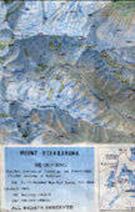
Mount Xixabangma
High quality survey map of the area extending from Mount Xixabangma (Shisha Pangma) in the south east to Yangan Kangri (Ganesh I) on the very edge of the map in the south west and including Nandanli (Langtang Ri) Peak and Kangboqen Peak. The contour interval is 40m but there is no grid and international borders are not shown. On the reverse is some relevant information translated into English.

Product Description
Reviews/Comments
Add New
Vouchers
No voucher codes found.
Do you know a voucher code for this product or supplier? Add it to Insights for others to use.
Do you know a voucher code for this product or supplier? Add it to Insights for others to use.
 Denmark