More From Contributor
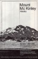
£12.95
The Mount Kailash Trek is Sian Pritchard-Jones & Bob Gibbons’ Cicerone guide to trekking on the mythical Buddhist mountain that stands at 6714m, located behind the Himalaya. The guide covers the 3-4 day route around the sacred peak & though short, is very isolated & remote & undertaken at high altitudes, following the path of pilgrims for a thousand years. The mountain has for been a central pilgrimage site fro some of the world’s major religions for hundreds of years. The guide also

Includes::
a visit to the lost kingdom of Guge & its former capital Tsaparang, home to Tibet’s greatest Buddhist treasure house of art & paintings. The guide is structured in 6 main sections – Approach routes to Kailash (including three possibilities), The Kailash Kora trek, Other Treks in the Kailash region, the Guge Kingdom & a section dedicated to a Return to Kathmandu or Lhasa. Each route has an Information Box providing details on altitude range & gain, time, total distance & the trek’s highest point. A comprehensive introduction gives practical guidance on pre-departure preparation, styles of trek, accommodation & food, visas & permits, health considerations, mountain sickness & getting there. There is also a general exploration of Tibetan landscapes & the local flora & fauna & climate. Extensive appendices provide a glossary of Bon & Buddhist deities, route summaries, language hints & films & music. Detailed route descriptions are accompanied by colour sketch diagrams mapping the route in addition to colour photographs illustrating some of the highlights of these dramatic mountain landscapes.

...
Archived Product
£9.95
Double-sided sheet combining three maps of the mountain at various scales, drawings of its peaks annotated with hiking & climbing routes, & information on for hikers & climbers. The main map at 1:50, 000 & an enlargement of the peak area at 1:25, 000 have contours at 50m intervals, show glaciers, scree, cliffs & rocky ridges, as well as different types of vegetation, plus hiking & climbing routes, shelters & unmanned huts, rangers’ posts, etc. Neither map has geographical coordinates. A separate inset at 1:400, 000 shows the roads around Mt Kenya & access to it from local villages, indicating accommodation, medical facilities, petrol stations, etc. Latitude & longitude are marked at 30’ intervals. On the reverse there are diagrams showing the routes to the peaks from the south-west & the north, with more detailed diagrams for the North Face standard route & the south-east face of the Nelion summit, all with path & climbing routes indicating the degree of difficulty. Extensive text in English, French, German & Italian provides general information on the routes, climate, flora & fauna, plus advice on equipment & some useful contact details. ...
Archived Product
£12.99
Available exclusively from Stanfords in advance of publication date (29th May). Did you know that an invisible mountain is rising above the streets of the capital
- &, at over 1, 400 metres, it is Britain`s highest peak? This ingenious new book is an account of the ascent of Mount London by a hardened team of writers, poets & urban cartographers, each one scaling a smaller mountain within the city
- from Crystal Palace (112m) to Primrose Hill (78m)
- until the accumulative climb exceeds the height of Ben Nevis. The essays & stories in Mount London unpeel London`s history, geography & psychogeography, reimagining the city as mountainous terrain & exploring what it`s like to move through the urban landscape. Ascents of London`s natural peaks are offset by expeditions to the artificial mountains of the city
- the Shard (306m), the chimneys of Battersea Power Station (103m)
- & the search for `ghost hills` in the back streets of Whitechapel & Finsbury. With contributions by Helen Mort, Joe Dunthorne, Sarah Butler, Inua Ellams, Bradley Garrett & many more, Mount London is a unique & visionary record of the vertical city.


...
Archived Product
£9.99
Mount Makalu, sheet no. 2787-01, in the topographic survey of Nepal at 1:50, 000 published by the Nepali Government in the late 1990s & early 2000s & produced from remote sensing data by Finnish cartographers as part of that country’s international aid program. The maps cover 15’ x 15’ quadrangles.IMPORTANT – PLEASE NOTE BEFORE ORDERING: AVAILABILITY: although, theoretically at least, still in print, these maps are very difficult to get locally in Nepal and/or from various suppliers elsewhere specializing in obtaining such maps. DELIVERIES MAY TAKE SEVERAL WEEKS OR EVEN MONTHS.PROBLEMS WITH PLACE NAMES: reports from previous users indicate that transliteration of place names differs from that used widely not only on other maps & in guide books but also on the ground itself, in road signs & in the tourist & trekking industry in general. Whilst most names are similar enough to be easily recognizable, e.g. Namche Bajar for Namche Bazar or Lantan for Langtang, we have been told of confusion & difficulties arising from different spellings appearing on these maps.TREKKING ROUTES & TOURIST INFORMATION: whilst the maps show foot trails & mark locations of temples, etc, they carry no specific trekking information. Major trekking routes & places of interest are not highlighted. There is no marking for base camps & other tourist facilities. Map specifications: Contours are at 40m intervals, with graphics and/or coloring to show various features of the terrain (glaciers with moraines & crevasses, quarries, gravel or clay pits, etc.) & vegetation (forests, bush, grass, orchards & plantations, etc). Additional comments such as “open mixed forest mainly bajh & pine” annotate many area. The maps have numerous spot heights, but relatively few peaks are named. Areas outside the country’s borders are left blank. Settlements in remote areas are indicated by markings for individual buildings & the placing of names does not always make it clear which group of buildings they refer to. Road network distinguishes between major & minor foot trails. Symbols mark features such as temples, schools & hospitals, police stations, etc. Also shown are the country’s administrative divisions. The maps have a 1-km UTM grid, plus latitude & longitude lines at intervals of 5’. Map legend & all the text is in English. Coverage: the whole country is now covered, with the north at 1:50, 000, plus central & southern Nepal at 1:25, 000. The two series are complementary, do not overlap & use the same grid & numbering system (apart from the Lumbini Zone, where a different grid & numbering are used). For areas not shown on our grid & titles not listed here, please contact us by e-mail, but please do bear in mind the problems with availability & the likely very long delivery time. One of the maps in the topographic survey of Nepal at 1:50, 000 published by the Nepali Government & produced from remote sensing data by Finnish cartographers as part of that country’s international aid program. The sheets cover 15’ x 15’ quadrangles. Contours are at 40m intervals, with additional graphics & coloring to show various features of the terrain (glaciers with moraines & crevasses, quarries, gravel or clay pits, etc.) & vegetation (forests, bush, grass, orchards & plantations, etc). Additional comments such as “open mixed forest mainly bajh & pine” annotate many areas on the maps. The maps have numerous spot heights, but relatively few peaks are named. Areas outside the country’s borders are left blank. Settlements in remote areas are indicated by markings for individual buildings & placing of names does not always make it clear with group of buildings they refer to (also see below for comments on transliteration). Road network distinguishes between major & minor foot trails. Symbols mark features such as temples, schools & hospitals, police stations, petrol pumps, etc. Also shown are the country’s administrative divisions. The maps have a 1km UTM grid, plus latitude & longitude lines at intervals of 5’. Map legend & all the text is in English.* Place names:* we have been advised that transliteration differs from that used widely not only on other maps & in books but also on the ground in road signs & in the tourist & trekking industry in general. Whilst most names are similar enough to be easily recognizable, e.g. Namche Bajar for Namche Bazar or Lantan for Langtang, we have been told of confusion & difficulties arising from different spellings appearing on the maps.* Trekking routes & tourist information:* whilst the maps show foot trails & mark locations of temples, etc., they carry no specific trekking information. Major trekking routes & places of interest are not highlighted. There is no marking for base camps & other tourist facilities.* Coverage*: the whole country is now covered, with the north at 1:50, 000 & central plus southern Nepal at 1:25, 000. The two series are complementary, do not overlap & use the same grid & numbering system (apart from the Lumbini Zone, where a different grid & numbering is used). For areas not shown on our grid & titles not listed here, please contact us by e-mail.* Availability:* the maps were published in late 1990s & early 2000s & by now some sheets are out of print. We cannot guarantee availability or any particular delivery time.* In this title:* Mount Makalu & adjoining peaks. ...
Archived Product
£9.99
Map No. 749, Mount Mansfield – Stowe in Vermont, in an extensive series of GPS compatible, contoured hiking maps of USA’s national & state parks or forests & other popular recreational areas. Cartography based on the national topographic survey, with additional tourist information. The maps, with most titles now printed on light, waterproof & tear-resistant plastic paper, highlight walking trails along with campsites & other accommodation, picnic sites, areas for various recreational pursuits such as horse riding or skiing, drinking water sources, & many other facilities of interest to the outdoor enthusiast. Cartography is based on information from the USGS (United States Geological Survey
- the country’s national survey organization), revised by the National Geographic Maps in cooperation with the National Park Service, USDA Forest Service, etc. Topography is excellently presented by contours (interval varies according to scale), enhanced by relief shading & colouring/graphics for wood cover, glaciers, etc. All heights are given in feet. The maps have a UTM grid plus latitude & longitude margin ticks & GPS waypoints for selected important locations. Each map is double-sided to give either maximum coverage of the chosen area or additional enlargements of its important sections. Accompanying notes provide useful information on relevant regulations, safety precautions, contact addresses, etc.* *IMPORTANT
- PLEASE NOTE: the series is very extensive, ranging in scale from 1:400, 000 for the vast national parks of Alaska to 1:25, 000 for local map in several states. We recommend, therefore, viewing the series by state rather than the whole list.*

...
Archived Product
£9.00
Detailed, full-colour topographical map of Mount Mulanje, Malawi. Published with the Mountain Club of Malawi. 25m contours, full colour. Useful information on walking routes, accommodation, history, flora & fauna, weather, geology. Photographs of area. ...
Archived Product
£9.95
Mount Olympos in the eastern Lycia region of Turkey on a detailed, contoured, GPS compatible map at 1:54, 000 from EWP showing the course of the Lycian Way, with a list of useful addresses including accommodation, etc. The map uses as its base the old Soviet military survey, adapted by the publishers to reflect current information. Contours are at 40m intervals. The course of the waymarked Lycian Way is indicated & other local paths are shown including mountain routes to peak of Mt Olympos. Other information

Includes::
rock climbing sites, archaeological remains, locations of petrol stations, bus stations, etc. Latitude & longitude lines are drawn at 2’ intervals. Map legend is in English, Turkish & German. On the reverse are English language notes about the Lycian Way, useful contact details including accommodation, places to eat, etc, plus numerous colour photos.

...
Archived Product
£8.50
Pelion Peninsula with Mt Mavrovouni on a waterproof & tear-resistant, double-sided, contoured & GPS compatible hiking map at 1:45, 000 from Anavasi highlighting 20 recommended hiking trails, beaches, campsites, etc. All place names are in both Greek & Latin alphabet. Coverage extends from the southern tip of the peninsula northwards across Mt. Pelio & Volos to Sklithro north of Mt Mavrovouni. The map has contours at 20m intervals, with light relief shading, altitude colouring & numerous spot heights. Road network indicates dirt roads in poor condition, gives distances on most small local roads, & shows locations of petrol stations. Footpaths are graded to show narrow or poorly defined paths, with 20 recommended routes highlighted & cross-referenced to details of their length & approximate hiking time. Symbols mark locations of various places of interest, including campsites, beaches, archaeological sites, etc. The map has a 1km UTM grid plus crosshairs at 1’ intervals. Detachable map cover

Includes::
an index of settlements in both scripts. Map legend & all the text include English. To see the list of titles in this series please click on the series link.

...
Archived Product
£24.00
High quality survey map of the area around Mount Qomolangma (Mount Everest). The map extends north & east to the heads of the trails on the Tibetan side, & south to Pangboche. Makalu & Cho Oyu also appear. The contour interval is 40m but there is no grid & international borders are not shown. On the reverse is some relevant information translated into English. ...
Archived Product
£9.99
Mount Rainier National Park in Washington State at 1:50, 000 a series of detailed, contoured maps from Earthwalk Press with cartography based on the USGS topographic survey of the country plus additional information for visitors, printed on light, waterproof & tear-resistant synthetic paper. Enlargements show in greater detail enlarged Paradise, Sunrise, Longmire & Ohanapecosh; alsp provided is an elevation profile of the Wonderland Trail. Maps in this series have contours usually at 40 feet & all heights are also given in feet. Colouring shows forested areas, plus, where necessary, additional graphics indicate other important topographic features such as marshland/swamps, moraine, etc. Hiking trails are highlighted, showing where appropriate their trail numbers and/or names. Icons highlight locations of trailheads, campgrounds, picnic areas, ranger stations, plus where available other recreational facilities. Local road network indicates light duty & unimproved dirt roads. GPS coordinates are given as margin ticks. Each title

Includes::
comprehensive additional text with useful information, including weather & water warning, regulations, etc, usually prepared by local summer rangers with good knowledge of the area.

...
Archived Product

Mount McKinley

Folded map with excellent topographical relief shown with a vertical contour interval at 100ft. Spot heights are given for major peaks. Natural features & vegetation shown. No roads or habitation on area of map. Because of the amount of snow/ice the general colours of the map are shades of a pleasing light-blue. Nice to look at and practical to use. So if you do get yourself lost (you shouldn`t with this map and a compass) or stuck then at least you will have a pretty map to look at whilst waiting to be rescued.
RIP - This product is no longer available on our network. It was last seen on 25.09.2019

This page now acts as a permanent archive for this product. Add more information using the comments box below to ensure it can still be found by future generations.

Use our search facility to see if it is available from an alternative contributor.
  • External links may include paid for promotion
  • Availability: Out Of Stock
  • Supplier: Stanfords
  • SKU: XL00000024515
Availability: In Stock
£20.95

Product Description

Folded map with excellent topographical relief shown with a vertical contour interval at 100ft. Spot heights are given for major peaks. Natural features & vegetation shown. No roads or habitation on area of map. Because of the amount of snow/ice the general colours of the map are shades of a pleasing light-blue. Nice to look at & practical to use. So if you do get yourself lost (you shouldn`t with this map & a compass) or stuck then at least you will have a pretty map to look at whilst waiting to be rescued.

Reviews/Comments

Add New

Intelligent Comparison

Oooops!
We couldn't find anything!
Perhaps this product's unique.... Or perhaps we are still looking for comparisons!
Click to bump this page and we'll hurry up.

Price History

Vouchers

No voucher codes found.
Do you know a voucher code for this product or supplier? Add it to Insights for others to use.

Facebook

Jargon Buster

Ice - Frozen water, the solid state of water.
Blue - A primary colour
Natural - not manmade
Ice - Frozen water, Ice is cold to the touch and forms when water reaches 0 degrees centigrade.
Snow - Water and vapour in clouds that falls in a white crystal form leaving a white layer.
Practical - Weather a task is easy to carry out and realistically succeed.

Supplier Information

Stanfords
Stanfords was established in 1853 and opened their iconic Covent Garden flagship store in 1901. They have become the top retailer of maps, travel books and accessories in the UK and arguably offer the largest selection of maps and travel books worldwide. Famous names such as Captain Robert Falcon Scott, Ranulph Fiennes and Michael Palin have purchased from Stanfords. They now have a shop in Bristol and both stores together with other venues operate a calendar of events including talks, book signings and exhibitions. As a specialist map retailer, the map selection is comprehensive and includes road maps, street maps and walking maps from worldwide destinations, as well as a selection of world atlases and wall maps. Books include travel guides and travel literature. Stanfords also stock globes, from miniatures made of blue marble to magnificent floor-standing globes. The website features a selection of interesting articles on travel topics.
Page Updated: 2023-11-12 20:15:36

Community Generated Product Tags

Oh No! The productWIKI community hasn't generated any tags for this product yet!
Menu