More From Contributor
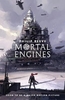
£6.50
Topographic coverage of the Canary Islands at 1:25, 000 published by the Instituto Geográfico Nacional – Centro Nacional de Información Geografica, the country’s civilian survey organization. The maps have contours at 10m intervals & colouring and/or graphics to show different types of vegetation or land use. Boundaries of national parks & other protected areas are marked. In addition to all the usual information shown on topographic mapping at this scale: detailed presentation of the road network with rural tracks & paths, etc, the maps also show campsites. The maps have a 1-km UTM grid, plus margin ticks for latitude & longitude at 1` intervals. The majority of the titles have been published since late 1990s. Map legend is in Spanish only.COVERAGE: each 25K map covers one quarter of the corresponding 1:50, 000 map, with the numbering system: I = NW quarter, II = NE quarter, III = SW quarter, & IV = SE quarter. To see other titles in this series please click on the series link. ...
Archived Product
£6.95
Morro Jable area of Fuerteventura, map No. 1099 in the topographic coverage of the Canary Islands at 1:50, 000 from the Instituto Geográfico Nacional
- Centro Nacional de Información Geograficá, Spain’s civilian survey organization. Maps in the MTN50 (Mapa Topográfico Nacional) series begun in late 1990s have contours at 20m intervals enhanced by relief shading, plus colouring and/or graphics to show different types of terrain, vegetation or land use. Boundaries of national parks & other protected areas are marked. In addition to all the usual information shown on topographic maps at this scale, detailed presentation of the road & rail networks, rural tracks & paths, etc, the maps also show campsites & mountain refuges. The maps have a 1-km UTM grid, with margin ticks for latitude & longitude at 1` intervals. Map legend is in Spanish only. PLEASE NOTE: not all the maps may as yet reflect the changes in road numbering on the islands. To see other titles in this series please click on the series link.
...
Archived Product
£6.50
Topographic coverage of mainland Spain at 1:25, 000 published by the Centro Nacional de Información Geograficá, the country’s civilian survey organization. The maps have contours at 10m intervals & colouring and/or graphics to show different types of vegetation or land use. Boundaries of national parks & other protected areas are marked. In addition to all the usual information shown on topographic maps at this scale, detailed presentation of the road & rail networks, rural tracks & paths, etc, the maps also show campsites. The maps have a 1-km UTM grid, with margin ticks for latitude & longitude at 1` intervals. Map legend is in Spanish only.PLEASE NOTE: our grid for the whole of Spain is in preparation
- in the meantime, for areas other than those shown on the attached grid please use CNIG’s topographic survey at 1:50, 000 by searching for ‘SI00000832’. Each 25K map covers one quarter of the corresponding 50K map, with the numbering system: I = NW quarter, II = NE quarter, III = SW quarter & IV = SE quarter. CNIG maps in the Provincial Road Maps series at 1:200, 000 are overprinted with the grid for the 1:50, 000 survey & can be used to see the area covered by each 50K or 25K title in more detail. To see the list of titles in this series please click on the series grid
- for map numbers not yet listed on our website please contact us by email.

...
Archived Product
£9.00
36 cards showing the Morse symbol, both letters & numerals, with the back of the card giving the meaning. Also in the set is a useful instruction card. For those mariners needing a knowledge of Morse these Flip Cards have proved to be a quick & simple method of learning & checking.37 cards in total. ...
Archived Product
£12.99
Topographic survey of France at 1:25, 000 in IGN`s excellent TOP25 / Série Bleue series. All the maps are GPS compatible, with a 1km UTM grid plus latitude & longitude lines at 5’ intervals. Contours are at 5m intervals except for mountainous areas where the maps have contours at 10m intervals, vividly enhanced by hill shading & graphics for rocky terrain. Colouring with graphics indicates different types of vegetation or land use (deciduous or coniferous forests, moors, orchards, vineyards, etc). PLEASE NOTE: coverage of France at this scale is currently being revised – the format & the presentation of each title are indicated by the letters at the end of its Sheet Reference number (e.g. 0416ET, 3531ETR, 1923SB, etc.)MAPS WITH FULL TOURIST OVERPRINT & AN ENGLISH MAP LEGEND: all TOP25 maps & the SB editions of Série Bleue have an overprint highlighting waymarked walking trails including long-distance GR routes &, where appropriate, ski routes. Symbols indicate campsites, gîtes d’etape, refuges, equestrian centres & other recreational facilities or sites, tourist information centres, cultural heritage, etc. Towns & locations of particular interest are highlighted.- ET or OT = single-sided TOP25 map covering approx. 29x 21 km / 18x 13 miles.- ETR or OTR = waterproof & tear resistant TOP25 map covering the same area as the corresponding ET or OT number, but double-sided, printed on a smaller size sheet with a good overlap between the sides.- SB = Série Bleue map with full tourist overprint; these maps, first introduced in summer 2014, each cover approx. 29x 24km / 18x 15 miles.SÉRIE BLEUE maps with numbers ending in E (Est) or O (Ouest): most editions now indicate the GR routes, but do not show any other tourist information. Map legend is in French only. Each map covers approx. 14x 20km / 9x 12 miles. ...
Archived Product
£7.99
MORTAL ENGINES launched Philip Reeve`s brilliantly-imagined creation, the world of the Traction Era, where mobile cities fight for survival in a post-apocalyptic future. Now, in time for the film debut, the critically acclaimed MORTAL ENGINES quartet is repackaged with a fantastic & eye-catching cover featuring new artwork. In a dangerous future, huge motorized cities hunt, attack & fight each other for survival. As London pursues a small town, young apprentice Tom is flung out into the wastelands, where a terrifying cyborg begins to hunt him down. The first book in the award-winning MORTAL ENGINES quartet. ...
Archived Product
£8.99
Sixteen-year-old Canny Mochrie`s holiday takes a turn when she stumbles upon a mysterious & enchanting valley, occupied almost entirely by children who can perform a special type of magic that tells things how to be stronger & better than they already are. As Canny studies the magic more carefully, she realizes that she not only understands it
- she can perform the magic, too, so well that it feels like it has always been a part of her. With the help of an alluring seventeen-year-old boy who is held hostage by a spell that is now more powerful than the people who first placed it, Canny figures out the secrets of this valley & of her own past.
...
Archived Product
£12.99
Topographic survey of France at 1:25, 000 in IGN`s excellent TOP25 / Série Bleue series. All the maps are GPS compatible, with a 1km UTM grid plus latitude & longitude lines at 5’ intervals. Contours are at 5m intervals except for mountainous areas where the maps have contours at 10m intervals, vividly enhanced by hill shading & graphics for rocky terrain. Colouring with graphics indicates different types of vegetation or land use (deciduous or coniferous forests, moors, orchards, vineyards, etc). PLEASE NOTE: coverage of France at this scale is currently being revised – the format & the presentation of each title are indicated by the letters at the end of its Sheet Reference number (e.g. 0416ET, 3531ETR, 1923SB, etc.)MAPS WITH FULL TOURIST OVERPRINT & AN ENGLISH MAP LEGEND: all TOP25 maps & the SB editions of Série Bleue have an overprint highlighting waymarked walking trails including long-distance GR routes &, where appropriate, ski routes. Symbols indicate campsites, gîtes d’etape, refuges, equestrian centres & other recreational facilities or sites, tourist information centres, cultural heritage, etc. Towns & locations of particular interest are highlighted.- ET or OT = single-sided TOP25 map covering approx. 29x 21 km / 18x 13 miles.- ETR or OTR = waterproof & tear resistant TOP25 map covering the same area as the corresponding ET or OT number, but double-sided, printed on a smaller size sheet with a good overlap between the sides.- SB = Série Bleue map with full tourist overprint; these maps, first introduced in summer 2014, each cover approx. 29x 24km / 18x 15 miles.SÉRIE BLEUE maps with numbers ending in E (Est) or O (Ouest): most editions now indicate the GR routes, but do not show any other tourist information. Map legend is in French only. Each map covers approx. 14x 20km / 9x 12 miles. ...
Archived Product
£2.99
Mortehoe & Woolacombe area of northern Devon on a very detailed, GPS compatible hiking, cycling & horse riding map from Croydecycle at 1:12, 500, printed on light, waterproof & tear-resistant synthetic paper. The map is part of publishers’ series covering the western coast of Somerset, both coastlines of Devon, & the adjoining areas of Dorset. Each handy size, 50 x 35cm, map is double-sided to cover a wider area. Topography is indicated by contours at 10m intervals with graphics and/or colouring for different type of terrain (s&, shingle, mud, high or low cliffs, etc) & vegetation (woodlands, gorse, scrub, etc). An overprint highlights footpaths, permissive paths & small permissive paths, Bridleways, cycle tracks & country roads which are byways for all traffic. On other roads markings indicate routes which are part of the National Cycle Network. Symbols show locations of campsites & caravan sites, riding stables, pubs/cafes/restaurants, shops & other local facilities, etc. For GPS users each map has in the margins National Grid coordinates. Most 1:12, 500 maps include enlargements of main town (s), an inset providing geological information, & details of transport options. To see other titles in this series, including cycle maps, please click on the series link. The 1:12, 500 maps are numbered on our website westwards along the Somerset & north Devon coast, & then eastwards along the southern coast of Devon & into Dorset. ...
Archived Product
£10.99
Morvan Regional Park in a series of GPS compatible, contoured TOP 75 maps at 1:75, 000 from the IGN, highlighting local & long-distance hiking paths, cycling routes & sites for other recreational activities. The map

Includes::
five large panels showing the areas around Vézelay, Anost, Saint-Brisson, Lac des Settons, & Mont Beuvray on IGN’s topographic mapping at 1:25, 000 with extensive overprint for local hiking paths & tourist facilities including campsites. Cartography of the main map at 1:75, 000 is a direct enlargement of the mapping used in the IGN’s TOP100 series. Contours are at 40m intervals, enhanced by relief shading; additional colouring shows different types of vegetation (woods, brushwood, vineyards/orchards). Boundaries of national parks & other protected areas are marked. An overprint highlights long-distance GR hiking routes & cycling trails. Symbols
- more numerous than on the TOP100 maps
- indicate various places of interest including mountain refuges & gîtes d’etape (campsites on the enlargements), areas for other recreational pursuits such as climbing, hand gliding or water & winter sports, historic or cultural sites, etc. The map has a UTM grid & an index of communes. Map legend

Includes::
English. To see the list of other maps in this series please click on the series link.


...
Archived Product

Mortal Engines

MORTAL ENGINES launched Philip Reeve`s brilliantly-imagined creation, the world of the Traction Era, where mobile cities fight for survival in a post-apocalyptic future, and is now released with a film tie-in cover. The first installment introduces young apprentice Tom Natsworthy and the murderous Hester Shaw, flung from the fast-moving city of London into heart-stopping adventures in the wastelands of the Great Hunting Ground. ”No 11-to-16-year-old should miss the superbly imagined debut novel from Philip Reeve” - The Times ”This big, brave, brilliant book combines a thrilling adventure story with endless moral conundrums” - Guardian
RIP - This product is no longer available on our network. It was last seen on 25.09.2019

This page now acts as a permanent archive for this product. Add more information using the comments box below to ensure it can still be found by future generations.

Use our search facility to see if it is available from an alternative contributor.
  • Availability: Out Of Stock
  • Supplier: Stanfords
  • SKU: 9781407188959
Availability: In Stock
£7.99

Product Description

MORTAL ENGINES launched Philip Reeve`s brilliantly-imagined creation, the world of the Traction Era, where mobile cities fight for survival in a post-apocalyptic future, & is now released with a film tie-in cover. The first installment introduces young apprentice Tom Natsworthy & the murderous Hester Shaw, flung from the fast-moving city of London into heart-stopping adventures in the wastelands of the Great Hunting Ground. ” No 11-to-16-year-old should miss the superbly imagined debut novel from Philip Reeve”
- The Times ” This big, brave, brilliant book combines a thrilling adventure story with endless moral conundrums”
- Guardian

Reviews/Comments

Add New

Intelligent Comparison

Oooops!
We couldn't find anything!
Perhaps this product's unique.... Or perhaps we are still looking for comparisons!
Click to bump this page and we'll hurry up.

Price History

Vouchers

No voucher codes found.
Do you know a voucher code for this product or supplier? Add it to Insights for others to use.

Facebook

Jargon Buster

World - A physical grouping, commonly used to describe earth and everything associated with ti
Year - The time it takes the planet earth to orbit the sun. This takes around 365.25 days.
Heart - An organ that pumps blood around the body. Usually related to love.
Adventure - an undertaking of an exciting challenge or experience.
Year - 365 days (366 days in a leap year), the time taken for planet earth to make one full revolution around the sun.

Supplier Information

Stanfords
Stanfords was established in 1853 and opened their iconic Covent Garden flagship store in 1901. They have become the top retailer of maps, travel books and accessories in the UK and arguably offer the largest selection of maps and travel books worldwide. Famous names such as Captain Robert Falcon Scott, Ranulph Fiennes and Michael Palin have purchased from Stanfords. They now have a shop in Bristol and both stores together with other venues operate a calendar of events including talks, book signings and exhibitions. As a specialist map retailer, the map selection is comprehensive and includes road maps, street maps and walking maps from worldwide destinations, as well as a selection of world atlases and wall maps. Books include travel guides and travel literature. Stanfords also stock globes, from miniatures made of blue marble to magnificent floor-standing globes. The website features a selection of interesting articles on travel topics.
Page Updated: 2023-11-12 20:15:36

Community Generated Product Tags

Oh No! The productWIKI community hasn't generated any tags for this product yet!
Menu