
 United Kingdom
 France
 Germany
 Netherlands
 Sweden
 USA
USA
 Italy
Italy
 Spain
Spain
More From Contributor


Morocco Reise Know-How
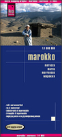
Morocco at 1:1, 000, 000 on an indexed road map with topographic and tourist information, printed on light, waterproof and tear-resistant plastic paper. The map, part of Reise Know-How’s highly acclaimed World Mapping Project, is double-sided to provide the best balance between a good scale and a convenient size sheet. The map divides Morocco north/south with a generous overlap between the sides: Marrakesh, the Toubkal Massif and Essaouira are included on both sides. The southern part of Western Sahara is shown as an inset at 1:2, 500, 000. Names of larger towns are additionally given in Arabic.Topography is indicated by altitude colouring with spot heights and mountain passes, names of mountain ranges and peaks, seasonal rivers and lakes, salt pans, oases and wells. National
parks are highlighted. Road information includes dirt roads and tracks, indicating scenic routes, locations of petrol stations and river fords, plus intermediate driving distances on main routes. Railways and local airfields are also shown. Symbols mark various places of interest: campsites, UNESCO World Heritage sites, forts and religious buildings, archaeological sites, beaches, surfing and fishing locations, viewpoints, etc. The map has a latitude/longitude grid at intervals of 1º and an index of localities. Map legend includes English.
parks are highlighted. Road information includes dirt roads and tracks, indicating scenic routes, locations of petrol stations and river fords, plus intermediate driving distances on main routes. Railways and local airfields are also shown. Symbols mark various places of interest: campsites, UNESCO World Heritage sites, forts and religious buildings, archaeological sites, beaches, surfing and fishing locations, viewpoints, etc. The map has a latitude/longitude grid at intervals of 1º and an index of localities. Map legend includes English.

Product Description
Reviews/Comments
Add New
Vouchers
No voucher codes found.
Do you know a voucher code for this product or supplier? Add it to Insights for others to use.
Do you know a voucher code for this product or supplier? Add it to Insights for others to use.
 Denmark