
 United Kingdom
 France
 Germany
 Netherlands
 Sweden
 USA
USA
 Italy
Italy
 Spain
Spain
More From Contributor


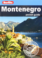
Montenegro Pocket Guide
It may be small, but Montenegro is blessed with an immense variety of dramatic scenery from tumbling peaks to sapphire beaches, and made culturally rich with layers of history. Be inspired to visit by the brand new Berlitz Pocket Guide Montenegro, a concise, full-colour guide to this emerging gem of a country that combines lively original text by an expert author with vivid photography to highlight the best that Montenegro has to offer.Inside Berlitz Pocket Guide Montenegro:Where To Go details all the key sights in the country, from the ”mini-Dubrovnik” of Budva and the beaches of Sveti Stefan to the ancient forests of Biogradska Gora National Park, while handy maps on the cover flaps help you find your way around, and are cross-referenced to the text.Top 10 Attractions gives a
run-down of the best sights to take in on your trip, including spiritual Ostrog Monastery and the relaxed squares of Herceg Novi.Perfect Tour provides an itinerary for a route around the country.What To Do is a snapshot of ways to spend your spare time, from lounging on beaches to shopping in the markets.Essential information on Montenegro`s culture, including a brief history of the country.Eating Out covers the country`s best cuisine.Curated listings of the best hotels and restaurants.A-Z of all the practical information you`ll need.About Berlitz: Berlitz draws on years of travel and language expertise to bring you a wide range of travel and language products, including travel guides, maps, phrase books,
run-down of the best sights to take in on your trip, including spiritual Ostrog Monastery and the relaxed squares of Herceg Novi.Perfect Tour provides an itinerary for a route around the country.What To Do is a snapshot of ways to spend your spare time, from lounging on beaches to shopping in the markets.Essential information on Montenegro`s culture, including a brief history of the country.Eating Out covers the country`s best cuisine.Curated listings of the best hotels and restaurants.A-Z of all the practical information you`ll need.About Berlitz: Berlitz draws on years of travel and language expertise to bring you a wide range of travel and language products, including travel guides, maps, phrase books,

Product Description
Reviews/Comments
Add New
Vouchers
No voucher codes found.
Do you know a voucher code for this product or supplier? Add it to Insights for others to use.
Do you know a voucher code for this product or supplier? Add it to Insights for others to use.
 Denmark