
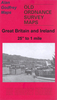
 United Kingdom
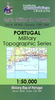
 France
 Germany
 Netherlands
 Sweden
 USA
USA
 Italy
Italy
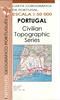
 Spain
Spain
More From Contributor


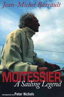
Moitessier - A Sailing Legend
In 1968 during the Golden Globe, the first solo non-stop race around the world, Bernard Moitessier sent the following message with a slingshot onto the deck of a freighter, ?I am continuing ?? With this unbelievable decision to turn his back on glory and money, when he had victory in his grasp, and continue sailing to the Pacific Islands after seven months at sea, he became a guru for all small boat sailors. Jean-Michel Barrault was his friend for 36 years. He met him when Moitessier, having survived two shipwrecks, went to Paris in search of work. He got him to start writing about his adventures, which Moitessier did beautifully. More adventures followed, a trip from Tahiti to Spain via Cape Horn as a honeymoon. After finishing The Long Way, his most famous book, Moitessier
and Joshua, his 39-foot ketch spent many years in Polynesia where he built his own house, planted coconut trees and transformed his atoll into a speck of green in the middle of the South Pacific.
and Joshua, his 39-foot ketch spent many years in Polynesia where he built his own house, planted coconut trees and transformed his atoll into a speck of green in the middle of the South Pacific.

Product Description
Reviews/Comments
Add New
Vouchers
No voucher codes found.
Do you know a voucher code for this product or supplier? Add it to Insights for others to use.
Do you know a voucher code for this product or supplier? Add it to Insights for others to use.
 Denmark