More From Contributor

£10.39
Map No. 181, Minehead & Brendon Hills, in a waterproof & tear-resistant version of the Ordnance Survey Landranger series at 1:50, 000, including Tiverton, Wellington, Watchet, Dulverton, Oare, Culbone, Porlock, Luccombe, Dunster, Williton, Kilve, Nether Stowey, Monksilver, Roadwater, Withycombe, Wheddon, Timberscombe, Exford, Withypool, Winsford, Exton, Hawkridge, Moll&, Upton, Wiveliscombe, Combe Florey, Halse, Norton Fitzwarren, Chipstable, Petton, Bampton, Ashbrittle, Exebridge, Knowstone, Oakford, Rackenford, Witheridge, Washfield, Cove, Huntsham, Westleigh, Uffculme & Culmstock, with the eastern part of the Exmoor National Park including Dunkery Hill & Wimbleball Lake, plus Quantock Hills, Blackdown Hills, Clatworthy Reservoir, Exe Valley & the north-easternmost section of the South West Coast Path. Edition D2; Revised for selected changes 2006, 2009; Copyright date 2009 This title is also available on our website in a paper version. Maps in this series are only published folded. Stanfords can also print flat versions of Ordnance Survey maps through the OS Select system, centring the map on a location of your choice & with a picture provided by you on the cover. For more information please click on the link at the bottom of this description. About Ordnance Survey ...
Archived Product
£14.99
Minehead with the eastern part of the Exmoor National Park including Brendon Hills, on a waterproof & tear-resistant OS Active version of map No. 181 from the Ordnance Survey’s Landranger series at 1:50, 000, with contoured & GPS compatible topographic mapping plus tourist information.MOBILE DOWNLOADS: As well as the physical edition of the map, each Landranger title now

Includes::
a code for downloading after purchase its digital version onto your smartphone or tablet for viewing on the OS smartphone app.OS LANDRANGER SERIES: to see the list of all the titles in the OS Landranger series, both paper & waterproof versions, please click on the series link. Maps in the Landranger series provide plenty of recreational & tourist information, indicating the traditional public right of way paths (except in Scotland where different laws apply), including bridleways & byways restricted or open to motorized traffic. National Trails & selected other long-distance paths are marked, as well as on-road & traffic-free cycle routes with their National/ Regional Cycle Network numbers. National Trust/ National Trust for Scotland & Forestry Commission land is clearly marked, indicating open or restricted access. A range of symbols highlights camping & caravanning sites, youth hostels, tourist information offices & visitors’ centres, parking & picnicking places, World Heritage sites, sport & recreational facilities, etc. The maps provide detailed presentation of topography with contours at 10m intervals, numerous spot heights & additional colouring and/or graphics for different types of woodlands, orchards or parkl&, rock features including scree & cliffs, water features inland & along the sea shore with marshl&, dunes, s&, mud, shingle & the high water mark. All the standard information expected of survey mapping at this scale is included: finely graded road network, railway lines with stations, cuttings, embankments, etc; individual isolated buildings; archaeological & historical sites, etc. For GPS users the British National Grid is shown at 1km intervals, with latitude & longitude given by margin ticks at 1` & cross hairs on the map at 5`. Each map covers an area of 40 x 40km, (approx. 25 x 25 miles).

...
Archived Product
£8.99
Minehead with the eastern part of the Exmoor National Park including Brendon Hills, on a paper version of map No. 181 from the Ordnance Survey’s Landranger series at 1:50, 000, with contoured & GPS compatible topographic mapping plus tourist information.MOBILE DOWNLOADS: As well as the physical edition of the map, each Landranger title now

Includes::
a code for downloading after purchase its digital version onto your smartphone or tablet for viewing on the OS smartphone app.OS LANDRANGER SERIES: to see the list of all the titles in the OS Landranger series, both paper & waterproof versions, please click on the series link. Maps in the Landranger series provide plenty of recreational & tourist information, indicating the traditional public right of way paths (except in Scotland where different laws apply), including bridleways & byways restricted or open to motorized traffic. National Trails & selected other long-distance paths are marked, as well as on-road & traffic-free cycle routes with their National/ Regional Cycle Network numbers. National Trust/ National Trust for Scotland & Forestry Commission land is clearly marked, indicating open or restricted access. A range of symbols highlights camping & caravanning sites, youth hostels, tourist information offices & visitors’ centres, parking & picnicking places, World Heritage sites, sport & recreational facilities, etc. The maps provide detailed presentation of topography with contours at 10m intervals, numerous spot heights & additional colouring and/or graphics for different types of woodlands, orchards or parkl&, rock features including scree & cliffs, water features inland & along the sea shore with marshl&, dunes, s&, mud, shingle & the high water mark. All the standard information expected of survey mapping at this scale is included: finely graded road network, railway lines with stations, cuttings, embankments, etc; individual isolated buildings; archaeological & historical sites, etc. For GPS users the British National Grid is shown at 1km intervals, with latitude & longitude given by margin ticks at 1` & cross hairs on the map at 5`. Each map covers an area of 40 x 40km, (approx. 25 x 25 miles).

...
Archived Product
£3.50
Minera in 1910 in a fascinating series of reproductions of old Ordnance Survey plans in the Alan Godfrey Editions, ideal for anyone interested in the history of their neighbourhood or family. The map covers the industrial village of Minera, just north-west of Wrexham. Features include the Minera Lead Mines, Pentre, St Mary`s church, part of the community known as New Brighton, Minera Hall, Pen-y-Bryn, Silica mine, Minera Lime Works, New Minera Lead Mine, etc. A mineral railway is shown to the lead mines & an aerial ropeway to Silica mine. A stretch of the GWR Wrexham & Minera branch is also included with Berwig Halt, Vicarage Crossing Halt & Coedpath station. On the reverse is a directory for Minera in 1910, plus a railway timetable for the GWR branch from Wrexham to Berwig Halt in 1906. About the Alan Godfrey Editions of the 25” OS Series: Selected towns in Great Britain & Ireland are covered by maps showing the extent of urban development in the last decades of the 19th & early 20th century. The plans have been taken from the Ordnance Survey mapping & reprinted at about 15 inches to one mile (1:4, 340). On the reverse most maps have historical notes & many also include extracts from contemporary directories. Most maps cover about one mile (1.6kms) north/south, one & a half miles (2.4kms) across; adjoining sheets can be combined to provide wider coverage.FOR MORE INFORMATION & A COMPLETE LIST OF ALL AVAILABLE TITLES PLEASE CLICK ON THE SERIES LINK. ...
Archived Product
£9.99
A practical & authoritative guide to identifying minerals, rocks & fossils. An invaluable handbook for amateur collectors & specialists alike, small & compact enough to carry in the pocket or rucksack. The illustrations in this revised edition have been enhanced to give a truer representation of the colours found in nature.A best-seller in its field since 1974 when it was first published, the 1998 edition has been completely revised & updated, with br&-new, extended introductory sections & appendices. The book has also been completely redesigned to bring it into the 1990s & make it more user friendly. Around 145 colour plates show typical mineral, rock & fossils specimens. The plates were photographed from the Natural History Museum's incredible collection. Over 100 specially commissioned line drawings illustrate the authoritative descriptions of the specimens. The 1998 edition has been updated & revised by two of the original authors (Dr Woolley & Dr Bishop), plus an expert in fossils, all from the world-class Natural History Museum in London. Main map scale: ...
Archived Product
£9.99
The Ming dynasty (1368-1644) is regarded as Chinas golden age, equivalent in British history to the Elizabethan era. Through the themes of people & places & a wealth of objects, this beautifully illustrated little book provides a concise & fascinating introduction to the Ming period. The colourful & rich nature of life for the emperors & their families within the vast palaces of Nanjing, Beijing & beyond is captured in the exquisite imperial portraits, paintings, costumes & jewellery. Beyond the courts, outdoor spaces were enjoyed by many people, & journeys into the countryside undertaken for different purposes. Parties were held in gardens with friends & sports such as football & golf kept people fit. Amongst other goods, Chinese porcelain & silk were highly regarded throughout the world at this time. The author looks at the main production centres, the extensive distribution networks, & the roles of craftsmen, salesmen & customers. As so much of our knowledge of Ming China derives from archaeology, tombs of royals & non-royals are featured & major finds from them illustrated. Religious sites monasteries, temples & mosques are also explored; rare surviving examples of architecture from the Ming period. The book concludes with an introduction to some of the imagined spaces of the Ming, including realms for various gods. Here are palaces & parks; tombs & temples; silk-production sites & sacred mountains; emperors & empresses; soldiers & salesmen; princes & potters: a visual feast that captures the flavour of the remarkable Ming dynasty. ...
Archived Product
£5.99
This is a new edition of this popular guide to England`s capital city. It contains a brief history of London from Roman times to today, as well as a guide to its people, places & tourist attractions such as the Natural History Museum, Buckingham Palace, Regent`s Park & London Zoo. It is packed with fascinating facts & trivia. It is an ideal guide for use by visitors both young & old or as a resource for projects. ...
Archived Product
£39.99
The Cabin Zero Travel Bag is designed & manufactured with the finest top quality materials,

Includes::
the

...
Archived Product
£39.99
The Cabin Zero Travel Bag is designed & manufactured with the finest top quality materials,

Includes::
the

...
Archived Product
£39.99
The Cabin Zero Travel Bag is designed & manufactured with the finest top quality materials,

Includes::
the

...
Archived Product

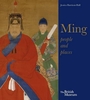
Ming: 50 Years That Changed China

Ask anyone what single object they associate with China and the most common answer will be a Ming vase. Probably without even knowing the dates of the Ming dynasty (1368-1644), people are aware of the fragility of its porcelain, its rarity and value. But porcelain is just one part of the story of one of the most glorious epoques of Chinas past. By focusing on the significant years of the early Ming dynasty and through the themes of court people and their lives, extraordinary developments in culture, the military, religion, diplomacy and trade, this magnificent book brings the wider history of this fascinating period to colourful life. This was an age of great voyages of exploration, undertaken for many reasons including trade and diplomacy. Long before the regular arrivals of
Europeans in China, court-sponsored expeditions were sent to Asia, the Middle East and the African coast, bringing back knowledge of and objects from lands thousands of miles away gold, gems and foreign fashions.This period also saw the compilation of the worlds first comprehensive encyclopaedia (worked on by over 2000 scholars); the undertaking of major building projects such as the Forbidden City and Ming tombs; the creation of beautiful textiles, paintings, ceramics, gold, jewellery, furniture, jade and lacquer. The engaging narrative is richly illustrated with over 250 images, drawing on the objects specially selected for the British Museums major exhibition. Some of these are the finest pieces ever made in China.
RIP - This product is no longer available on our network. It was last seen on 25.09.2019

This page now acts as a permanent archive for this product. Add more information using the comments box below to ensure it can still be found by future generations.

Use our search facility to see if it is available from an alternative contributor.
  • Availability: Out Of Stock
  • Supplier: Stanfords
  • SKU: 9780714124841
Availability: In Stock
£25.00

Product Description

Ask anyone what single object they associate with China & the most common answer will be a Ming vase. Probably without even knowing the dates of the Ming dynasty (1368-1644), people are aware of the fragility of its porcelain, its rarity & value. But porcelain is just one part of the story of one of the most glorious epoques of Chinas past. By focusing on the significant years of the early Ming dynasty & through the themes of court people & their lives, extraordinary developments in culture, the military, religion, diplomacy & trade, this magnificent book brings the wider history of this fascinating period to colourful life. This was an age of great voyages of exploration, undertaken for many reasons including trade & diplomacy. Long before the regular arrivals of Europeans in China, court-sponsored expeditions were sent to Asia, the Middle East & the African coast, bringing back knowledge of & objects from lands thousands of miles away gold, gems & foreign fashions. This period also saw the compilation of the worlds first comprehensive encyclopaedia (worked on by over 2000 scholars); the undertaking of major building projects such as the Forbidden City & Ming tombs; the creation of beautiful textiles, paintings, ceramics, gold, jewellery, furniture, jade & lacquer. The engaging narrative is richly illustrated with over 250 images, drawing on the objects specially selected for the British Museums major exhibition. Some of these are the finest pieces ever made in China.

Reviews/Comments

Add New

Intelligent Comparison

Oooops!
We couldn't find anything!
Perhaps this product's unique.... Or perhaps we are still looking for comparisons!
Click to bump this page and we'll hurry up.

Price History

Vouchers

No voucher codes found.
Do you know a voucher code for this product or supplier? Add it to Insights for others to use.

Facebook

Jargon Buster

Gold - A precious highly conductive metal
Porcelain - A ceramic material
Vase - A open container mainly used to hold cut flowers
Jewellery - A decorative item which is worn on the body
History - Anything that happens in the past. An acedemic subject.
Gold - A colour, a type of rich metal. Chemical symbol AU.

Supplier Information

Stanfords
Stanfords was established in 1853 and opened their iconic Covent Garden flagship store in 1901. They have become the top retailer of maps, travel books and accessories in the UK and arguably offer the largest selection of maps and travel books worldwide. Famous names such as Captain Robert Falcon Scott, Ranulph Fiennes and Michael Palin have purchased from Stanfords. They now have a shop in Bristol and both stores together with other venues operate a calendar of events including talks, book signings and exhibitions. As a specialist map retailer, the map selection is comprehensive and includes road maps, street maps and walking maps from worldwide destinations, as well as a selection of world atlases and wall maps. Books include travel guides and travel literature. Stanfords also stock globes, from miniatures made of blue marble to magnificent floor-standing globes. The website features a selection of interesting articles on travel topics.
Page Updated: 2023-11-12 20:15:36

Community Generated Product Tags

Oh No! The productWIKI community hasn't generated any tags for this product yet!
Menu