More From Contributor

£8.99
Back in 1947 someone called S.N. Pike
- we know next to nothing about him
- published three little pamphlets, each mapping

...
Archived Product
£12.99
Back in 1947 someone called S.N. Pike
- we know nothing more about him
- published three little pamphlets, each mapping in

...
Archived Product
£20.00
Travel back in time on a journey across Britain`s main-line railways on the eve of nationalisation. The views from the carriage windows are conveyed through finely detailed, h&-drawn maps, each a rich reminder of the linesides bursting with activity in an era of technical progress, glamour & prestige. Speed along the LNER`s racing track from King`s Cross to Newcastle upon Tyne & Edinburgh; from next-door St Pancras through the Peak District to Manchester; from Waterloo to Plymouth (with some pleasant seaside diversions on the way); from Euston through the industrial heartlands of the West Midlands & the north-west to the seaport of Liverpool; & from Paddington along Brunel`s `bowling green` railway to Bristol, Exeter & Penzance. Mile by Mile faithfully reproduces the three original route maps drafted in 1947 by S.N. Pike, & adds a new one for the Great Western Railway to complete its coverage of the so-called ` Big Four` railway firms formed in the aftermath of the First World War. New introductions describe how the ` Big Four` came about, the passengers & goods they conveyed, the key personalities that shaped them
- engineers, managers, even publicists
- & the trains & locomotives that gave each its unique character. Climb aboard, sit back & take a ride to a special period in the history of Britain`s railways.

...
Archived Product
£5.99
Erected to inform travellers how far they have come & how far they still have to go, milestones are a relic of a time when life moved more slowly. This book tells the story of milestones & the technology they reflect, as well as road measurement. It uses the great variety of designs & styles to argue the historical importance of conservation & to illustrate the compelling fascination of the subject. Mervyn Benford has worked in education all his professional life & has a consuming interest in history. Concerned at the rate at which evidence of the past disappears, often inadequately recorded, he believes that the understanding of history, the ability to understand cause & effect, to interpret evidence & to recognise what changes & what does not, are all central to an effective society. ...
Archived Product
£9.99
The 17 walks in Milestones to Millstones each focus on one mill or more in Oxfordshire & just beyond. The mills & the walks are very varied, such as: windmills on Warwickshire hilltops; or an Archimedes screw using the flow of the river beside an ancient watermill; & a steam mill attracting visitors of all ages. Part of the charm of the book is the explanation of milling idioms that are still in everyday use such as ” Keep your nose to the grindstone” or ” Come to a grinding halt”. All have suggested access points for shorter distances, information about public transport, & a list of teashops, pubs & accommodation. Each walk

Includes::
the relevant section of the Ordnance Survey map & is vividly illustrated throughout, giving archaeological, historical, botanical & local detail.

...
Archived Product
£9.99
Milford Track in the Fiordland National Park at 1:55, 000 in a series of contoured & GPS compatible maps from New Topo NZ Ltd, with exceptionally vivid presentation of the terrain, routes clearly highlighted, & symbols to show locations of various facilities. The map is double-sided & highlights the course of the 53.5-km long Milford Track indicting walking & tramping sections. Contour interval is 20m. Maps in the series from New Topo NZ Ltd cover the country ...
Archived Product
£13.99
Milford Track in the Fiordland National Park on a light, waterproof & tear-resistant, contoured & GPS compatible map at 1:38, 000 in a series from New Topo NZ Ltd, with exceptionally vivid presentation of the terrain, routes clearly highlighted, & symbols to show locations of various facilities. The map highlights the course of the 53.5-km long Milford Track from Lake Te Anau to the Milford Sound, indicting walking & tramping sections. Contour interval is 20m. Maps in the series from New Topo NZ Ltd cover the country’s popular hiking & tramping areas. The maps have contours (20m in most titles
- please confirm in the individual description) enhanced by relief shading, plus colouring and/or graphics to indicate various types of the terrain & vegetation: glaciers, scree, lava flows, shingle, s&, swamps, exotic forest, scrub, native bush, etc. The overprint for the routes distinguishes, as appropriate, between tramping tracks & routes, walking tracks, & waymarked or unmarked trails. Symbols show facilities such huts, campsites, public toilets, viewpoints, car parks, etc. Where useful, the maps also have brief notes about hut reservations. All the titles are GPS compatible, most with a 1-km NZ national grid (GPS users can uses WGS84). To see all the titles in this series please click on the series link.
...
Archived Product
£7.25
Interstate Drive Times & Distances Map (IDT &D) of United States from the Kappa Map Group, showing the country’s interstate highways annotated with distances in miles & driving times. On the reverse is a table showing driving distances between main towns using the interstate routes. Also provided is a separate list of the interstate highways shown on the map & an explanation of their numbering system. The map itself is very simple, but the information on it would come very useful for anyone planning a longer trip across the States, if only to avoid a mistake like the one once made by the writer of this description who innocently planed a day drive equivalent of a London – Edinburgh – Dublin – London round trip! ...
Archived Product
£9.99
1 New York Times bestseller Milk & Honey is a collection of poetry & prose about survival. About the experience of violence, abuse, love, loss, & femininity. The book is divided into four chapters, & each chapter serves a different purpose. Deals with a different pain. Heals a different heartache. Milk & Honey takes readers through a journey of the most bitter moments in life & finds sweetness in them because there is sweetness everywhere if you are just willing to look. ...
Archived Product
£25.00
` Lucy Inglis has done a wonderful job bringing together a wide range of sources to tell the history of the most exciting & dangerous plants in the world. Telling the story of opium tells us much about our faults & foibles as humans
- our willingness to experiment; our ability to become addicts; our pursuit of money. This book tells us more than about opium; it tells us about ourselves.`
- Peter Frankopan, author of The Silk Roads` The only thing that is good is poppies. They are gold.` Poppy tears, opium, heroin, fentanyl: humankind has been in thrall to the ` Milk of Paradise` for millennia. The latex of papaver somniferum is a bringer of sleep, of pleasurable lethargy, of relief from pain
- & hugely addictive. A commodity without rival, it is renewable, easy to extract, transport & refine, & subject to an insatiable global dem&. No other substance in the world is as simple to produce or as profitable. It is the basis of a gargantuan industry built upon a shady underworld, but ultimately it is a farm-gate material that lives many lives before it reaches the branded blister packet, the intravenous drip or the scorched & filthy spoon. Many of us will end our lives dependent on it. In Milk of Paradise, acclaimed cultural historian Lucy Inglis takes readers on an epic journey from ancient Mesopotamia to modern America & Afghanistan, from Sanskrit to pop, from poppy tears to smack, from morphine to today`s synthetic opiates. It is a tale of addiction, trade, crime, sex, war, literature, medicine &, above all, money. &, as this ambitious, wide-ranging & compelling account vividly shows, the history of opium is our history & it speaks to us of who we are.


...
Archived Product

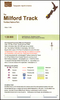
Milford And Kepler Tracks

One of the titles in a series of topographic maps of popular walking and recreational areas of New Zealand with contours at 20m intervals and relief shading. Perennial snow and ice contours are marked in blue and terrain information includes cliffs, saddles, moraine, scree, forest, scrub, etc. The maps show tracks and footpaths, with some paths indicating walking distances between marked points. A range of symbols depict campsites, huts, shelters, toilets and parking areas, fuel supplies, places of interest, etc. Latitude and longitude margin ticks are at 1' intervals, and the New Zealand Map Grid is printed over the map.In this title: two of New Zealand
RIP - This product is no longer available on our network. It was last seen on 30.10.2016

This page now acts as a permanent archive for this product. Add more information using the comments box below to ensure it can still be found by future generations.

Use our search facility to see if it is available from an alternative contributor.
  • Availability: Out Of Stock
  • Supplier: Stanfords
  • SKU: 9421015880059
Availability: In Stock
£8.95

Product Description

One of the titles in a series of topographic maps of popular walking & recreational areas of New Zealand with contours at 20m intervals & relief shading. Perennial snow & ice contours are marked in blue & terrain information

Includes::
cliffs, saddles, moraine, scree, forest, scrub, etc. The maps show tracks & footpaths, with some paths indicating walking distances between marked points. A range of symbols depict campsites, huts, shelters, toilets & parking areas, fuel supplies, places of interest, etc. Latitude & longitude margin ticks are at 1' intervals, & the New Zealand Map Grid is printed over the map. In this title: two of New Zealand

Reviews/Comments

Add New

Intelligent Comparison

Oooops!
We couldn't find anything!
Perhaps this product's unique.... Or perhaps we are still looking for comparisons!
Click to bump this page and we'll hurry up.

Price History

Vouchers

No voucher codes found.
Do you know a voucher code for this product or supplier? Add it to Insights for others to use.

Facebook

Jargon Buster

Forest - A area with a high density of trees
Ice - Frozen water, the solid state of water.
Blue - A primary colour
fuel - A material used to generate energy.
Ice - Frozen water, Ice is cold to the touch and forms when water reaches 0 degrees centigrade.
Snow - Water and vapour in clouds that falls in a white crystal form leaving a white layer.
Popular - Something that is admired and liked by many people.
perennial - A plant that lives for more than two years. Tending to bloom during spring and summer to die back to root over winter.

Supplier Information

Stanfords
Stanfords was established in 1853 and opened their iconic Covent Garden flagship store in 1901. They have become the top retailer of maps, travel books and accessories in the UK and arguably offer the largest selection of maps and travel books worldwide. Famous names such as Captain Robert Falcon Scott, Ranulph Fiennes and Michael Palin have purchased from Stanfords. They now have a shop in Bristol and both stores together with other venues operate a calendar of events including talks, book signings and exhibitions. As a specialist map retailer, the map selection is comprehensive and includes road maps, street maps and walking maps from worldwide destinations, as well as a selection of world atlases and wall maps. Books include travel guides and travel literature. Stanfords also stock globes, from miniatures made of blue marble to magnificent floor-standing globes. The website features a selection of interesting articles on travel topics.
Page Updated: 2023-11-12 20:15:36

Community Generated Product Tags

9421015880059 (1 person tagged the product this way)
Menu