More From Contributor
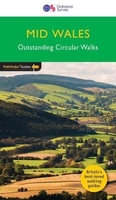
£3.00
Miniatures make us relive the world from the perspective of our childhood, a time when the world was populated by toys & figurines. Miniaturized worlds seethe with narrative potential, intricate story lines, suspense. They offer a disquieting experience of distance, & artists often use it to explore very contemporary feelings of alienation, displacement & estrangement. This book reveals how all kinds of visual artists (contemporary artists, street artists, photographers & even product designers) are using miniatures & miniaturized worlds in order to create startling situations & memorable images. The small people & small worlds featured give us a new sense of perspective, transporting us to a new dimension where we can find enchanted new cities, where people make homes out of pumpkins or go diving into breakfast bowls. Microworlds is a fascinating collection of images for anyone intrigued by these miniature, imagined worlds. ...
Archived Product
£3.50
Mid Berkshire in 1885 in a series of reproductions of Ordnance Survey’s famous ” Inch to the Mile” maps published in the Alan Godfrey Editions to provide a historical record of England & Wales in the second half of 19th & early 20th century. The map is centred on Reading, with coverage stretching from Hampstead Norris eastward to Wokingham, & from Streatley southward to Silchester & Stratfield Saye. Other locations include: in BERKSHIRE Aldermaston, Arborfield, Ashampstead, Barkham, Basildon, Beenham, Bradfield, Brimpton, Burghfield, Englefield, Finchampstead, Hurst, Padworth, Pangbourne, Purley-on-Thames, Ruscombe, Shinfield, Sonning, Stanford Dingley, Stratfield Mortimer, Sulham, Sulhampstead Abbots, Sulhampstead Bannister, Tidmarsh, Tilehurst, Twyford, Ufton Nervet, Wargrave & Wasing; in OXFORDSHIRE Caversham, Goring, Mapledurham & Whitchurch; plus in HAMPSHIRE Eversley. On the reverse is an extract from Berkshire Sheet 44.06 showing Aldermaston in 1898, complete with directory About the Alan Godfrey Editions of the OS Inch to the Mile Maps: the maps provide an invaluable overview of a wider area, typically 18 x 12 miles (29 x 19 kms approx.), & offer historical mapping for small towns & villages not covered by the more detailed series for which the Godfrey Editions are better known. On the reverse all the maps have historical notes & most titles also include a more detailed, large scale map of a small town or a village in the area. To see other titles in this series please click on the series link. ...
Archived Product
£3.50
Mid Finchley in 1894 in a fascinating series of reproductions of old Ordnance Survey plans in the Alan Godfrey Editions, ideal for anyone interested in the history of their neighbourhood or family. Two versions have been published for this area, extending from Finchley station eastward to St Pancras & Islington Cemetery. Features include Great North Road, Ballards Lane, Avenue House, GNR High Barnet Branch with Finchley station, Brent Lodge, Claigmar Vineyard, Fallow Corner, Green Man pub, Etchingham Lodge, Strawberry Vale House, Victoria Recreation Ground etc. Each version has on the reverse extracts from early directories. About the Alan Godfrey Editions of the 25” OS Series: Selected towns in Great Britain & Ireland are covered by maps showing the extent of urban development in the last decades of the 19th & early 20th century. The plans have been taken from the Ordnance Survey mapping & reprinted at about 15 inches to one mile (1:4, 340). On the reverse most maps have historical notes & many also include extracts from contemporary directories. Most maps cover about one mile (1.6kms) north/south, one & a half miles (2.4kms) across; adjoining sheets can be combined to provide wider coverage.FOR MORE INFORMATION & A COMPLETE LIST OF ALL AVAILABLE TITLES PLEASE CLICK ON THE SERIES LINK. ...
Archived Product
£3.50
Mid Finchley in 1911 in a fascinating series of reproductions of old Ordnance Survey plans in the Alan Godfrey Editions, ideal for anyone interested in the history of their neighbourhood or family. Two versions have been published for this area, extending from Finchley station eastward to St Pancras & Islington Cemetery. Features include Great North Road, Ballards Lane, Avenue House, GNR High Barnet Branch with Finchley station, Brent Lodge, Claigmar Vineyard, Fallow Corner, Green Man pub, Etchingham Lodge, Strawberry Vale House, Victoria Recreation Ground etc. Each version has on the reverse extracts from early directories. About the Alan Godfrey Editions of the 25” OS Series: Selected towns in Great Britain & Ireland are covered by maps showing the extent of urban development in the last decades of the 19th & early 20th century. The plans have been taken from the Ordnance Survey mapping & reprinted at about 15 inches to one mile (1:4, 340). On the reverse most maps have historical notes & many also include extracts from contemporary directories. Most maps cover about one mile (1.6kms) north/south, one & a half miles (2.4kms) across; adjoining sheets can be combined to provide wider coverage.FOR MORE INFORMATION & A COMPLETE LIST OF ALL AVAILABLE TITLES PLEASE CLICK ON THE SERIES LINK. ...
Archived Product
£11.99
Mid Wales & the Marches in the Pathfinder Guides series, produced in association with Ordnance Survey & published by Crimson; comprising a range of walking guides to popular British destinations. Each Pathfinder guide

Includes::
28 varied walks ranging from easy strolls to exhilarating hikes & is accompanied by 1:25, 000 Ordnance Survey mapping with marked, colour-coded routes. Introductory sections profile the county or region covered, with recommendations on the best time to visit & a brief explanation of GPS. An

...
Archived Product
£8.95
Detailed indexed road map of the coastal Western Australia, extending northwards from the Perth conurbation to North West Cape & Onslow, & eastwards to the Goldfields Highway from Kalgoorlie to Wiluna, & beyond to the Little Sandy Desert. Topography is shown by relief shading & names of mountain ranges & selected peaks. National parks, reserves, & state forests highlighted. Symbols indicate campsites & caravan parks, roadside rest areas, 24hour fuel supplies, information centres, places of interest, abandoned mining sites, etc. Latitude & longitude lines are drawn at 30' intervals. On the reverse five enlargements provide more detailed mapping & geographical coordinates (including a UTM grid) of: Cape Range National Park & the peninsula with the Ningaloo Marine Park (1:300, 000), the area around the Peron Peninsula with the Shark Bay Marine Park (1:900, 000), Kalbarri National Park & the environs of Northampton (1:500, 000), Kennedy Range National Park (1:400, 000), & Mount Augustus National Park/ Burringurrah (1:150, 000), There are also descriptions of main places of interest, contact addresses, & a table of facilities in the national parks. This title is part of Hema ...
Archived Product
£10.99
Detailed indexed road map of the coastal Western Australia at 1:1, 250, 000 from Hema with several enlargements showing most visited areas in greater detail, plus descriptions of various places of interest, a table of facilities in national parks, recommendations for 10 best 4WD tracks, etc. Coverage along the coast extends northwards from Perth to North West Cape & Onslow, plus eastwards to the Goldfields Highway linking Kalgoorlie & Wiluna, & beyond Wiliuna to the Little Sandy Desert. Topography is shown by relief shading & names of mountain ranges & selected peaks. National parks, reserves, & state forests highlighted. Symbols indicate campsites & caravan parks, roadside rest areas, 24hour fuel supplies, information centres, places of interest, abandoned mining sites, etc. Latitude & longitude lines are drawn at 30` intervals. The map is accompanied by an index, a distance table, plus a list of accredited information centres. On the reverse five enlargements provide more detailed mapping & geographical coordinates of: the Cape Range National Park & the peninsula with the Ningaloo Marine Park, the area around the Peron Peninsula & the Dirk Hartog Island with the Shark Bay Marine Park, the Kalbarri National Park & the environs of Northampton, the Kennedy Range National Park, plus Mount Augustus National Park (Burringurrah). There are also descriptions of main places of interest, contact addresses, & a table of facilities in the national parks. This title is part of Hema’s series of regional touring maps, providing more detailed or more convenient coverage of various regions of Australia than found on road maps of individual states or in the publisher`s ” City to City” series – to see the list of other titles in this series please click on the series link. ...
Archived Product
£8.50
Folded illustrated map & guide from Bella Terra showing Mid-Atlantic lighthouses, covering New Jersey, South East Pennsylvania, Delaware, Maryland & Virginia. The map shows route & highway numbers & the lighthouses themselves, with 30 original watercolour illustrations of selected lighthouses beside the map itself. The reverse of the map gives you detailed historical notes on the lighthouses themselves with additional information on directions & viewing spots, & a listing of lighthouse & marine museums in the area, as well as a ...
Archived Product
£24.95
A curated list of more than 250 must-see destinations organized geographically from Maine to Florida Featuring architecture by some of the biggest Mid-Century names, including Mies van der Rohe, Marcel Breuer, Eero Saarinen, & Philip Johnson, each of the more than 250 buildings is located on a regional map. The book

Includes::
all the additional information needed to find & visit each building. Its cool & functional design makes this book a coveted Modernist-style object in itself. Including icons from The Met Breuer to the fabulous beach houses of Fire Isl&, private homes in Connecticut, Manhattan skyscrapers, & the Tropical Modern residences of Sarasota, Florida, it is a must-have guide to one of the most fertile & lesser-known regions for the development of Mid-Century Modern architecture. From the publisher of Mid-Century Modern Architecture Travel Guide: West Coast USA.

...
Archived Product

Mid Wales

Overshadowed by Snowdonia to the north and the Brecon Beacons to the south, mid Wales is something of a `green desert`. Shrouded by Celtic mists, it baffled the advance of the English invaders, thus preserving the Welsh language in the west of Wales. The tranquil borderland of the Marches, offers a varied landscape truncated by rivers meandering to lowland plains. Limestone to the west and north of the old red sandstone of the Hereford Plain has given rise to exceptionally attractive hilly country with delightful, narrow valleys.
RIP - This product is no longer available on our network. It was last seen on 25.09.2019

This page now acts as a permanent archive for this product. Add more information using the comments box below to ensure it can still be found by future generations.

Use our search facility to see if it is available from an alternative contributor.
  • External links may include paid for promotion
  • Availability: Out Of Stock
  • Supplier: Stanfords
  • SKU: 9780319090879
Availability: In Stock
£12.99

Product Description

Overshadowed by Snowdonia to the north & the Brecon Beacons to the south, mid Wales is something of a `green desert`. Shrouded by Celtic mists, it baffled the advance of the English invaders, thus preserving the Welsh language in the west of Wales. The tranquil borderland of the Marches, offers a varied landscape truncated by rivers meandering to lowland plains. Limestone to the west & north of the old red sandstone of the Hereford Plain has given rise to exceptionally attractive hilly country with delightful, narrow valleys.

Reviews/Comments

Add New

Intelligent Comparison

Oooops!
We couldn't find anything!
Perhaps this product's unique.... Or perhaps we are still looking for comparisons!
Click to bump this page and we'll hurry up.

Price History

Vouchers

No voucher codes found.
Do you know a voucher code for this product or supplier? Add it to Insights for others to use.

Facebook

Jargon Buster

Red - One of the three primary colours
Language - the method of communication used in different areas. Humans and computers have many different languages.
Language - The way humans communicate either written and spoken.

Supplier Information

Stanfords
Stanfords was established in 1853 and opened their iconic Covent Garden flagship store in 1901. They have become the top retailer of maps, travel books and accessories in the UK and arguably offer the largest selection of maps and travel books worldwide. Famous names such as Captain Robert Falcon Scott, Ranulph Fiennes and Michael Palin have purchased from Stanfords. They now have a shop in Bristol and both stores together with other venues operate a calendar of events including talks, book signings and exhibitions. As a specialist map retailer, the map selection is comprehensive and includes road maps, street maps and walking maps from worldwide destinations, as well as a selection of world atlases and wall maps. Books include travel guides and travel literature. Stanfords also stock globes, from miniatures made of blue marble to magnificent floor-standing globes. The website features a selection of interesting articles on travel topics.
Page Updated: 2023-11-12 20:15:36

Community Generated Product Tags

Oh No! The productWIKI community hasn't generated any tags for this product yet!
Menu