
 United Kingdom
 France
 Germany
 Netherlands
 Sweden
 USA
USA
 Italy
Italy
 Spain
Spain
More From Contributor


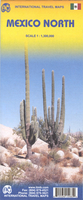
Mexico North ITMB
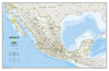
Double-sided road map of the northern half of Mexico, with topography indicated by altitude colouring. Peak heights are marked in metres. The map distinguishes between toll and free motorways and includes rural roads and selected tracks. Railway lines are also shown and symbols airports and airfields, archeological sites, beaches, caves, reefs, national parks and other sites of interest. The map has margin ticks for latitude and longitude at 1º intervals and an extensive index of localities.This title is part of a series of detailed touring maps of Mexico published by ITMB.

Product Description
Reviews/Comments
Add New
Intelligent Comparison
Archived Product

Mexico North-East ITMB Stanfords
£9.99
Archived Product
Mexico: North 20 Stanfords
£14.95
Archived Product
Mexico: North 16 Stanfords
£14.95
Archived Product

Mexico ITMB Stanfords
£9.99
Archived Product
Africa North ITMB Stanfords
£9.99
Vouchers
No voucher codes found.
Do you know a voucher code for this product or supplier? Add it to Insights for others to use.
Do you know a voucher code for this product or supplier? Add it to Insights for others to use.
 Denmark