More From Contributor

£10.95
Pocket-sized city guide to Melbourne from Explore Australia, aimed at those seeking the more hidden & less-beaten paths of this Australian city. Written by writers who live there, the guide is divided into four main sections: Hit the Streets; Treasure Trove; Feeling Peckish?; & Night Owl; each dedicated to sights, shopping, food & entertainment respectively. Each entry has a full colour photograph with an honest & informal review, useful information such as addresses, telephone numbers & a small ...
Archived Product
£5.95
Melbourne in the Wallpaper City Guide series, published by Phaidon & encompassing a collection of pocket-size guides dedicated to the best design elements in major cities. Compiled by experts at the Wallpaper magazine, the guides are widely recognized for appealing to design-conscious travellers & are aimed at those interested in art, design & architecture. Each guide identifies the best bars, restaurants, hotels, places to shop, leisure activities & excursions with a unique emphasis on the finest examples of unusual architecture & design. Each Wallpaper City Guide has the same layout, with separate tabs allowing readers & travellers to access individual sections easily. The tabs consist of Landmarks, Hotels, 24 Hours, Urban Life, Architour, Shopping, Sports & Escapes. High quality colour photographs appear alongside brief descriptions of each hotel, bar or attraction, highlighting distinctive & unusual styles of architecture & design. Extra pages are provided at the back of each guide, allowing readers to record their own notes & sketches. ...
Archived Product
£9.95
Melbourne & its region in a series of waterproof & tear-resistant maps of Australian cities & their environs, with each title combining a selection of maps: the central area, the suburbs, & the wider environs. The map of the central part, more diagrammatic in style than found in most tourist street plans, shows one way streets & main buildings, with its short index listing some accommodation & main places of interest. The map of the city with its suburbs has an index listing all the suburbs, while the maps of the environs have indexes of the localities & highlight places of interest. No geographical coordinates are shown on the maps. Also included are diagrams of highway connections to Australia ...
Archived Product
£9.99
Melbourne & Region in a series of maps from Hema presenting Australia’s main cities with three maps: a detailed street plan of the central area, a road map of the city with its outer suburbs, plus a map of the wider surrounding region for out-of-town excursions. The Melbourne map
Includes::- A street plan of city centre highlighting locations of 56 places of interest, 14 theatres, 12 travel information centres & 38 hotels.
- A road map of Greater Melbourne at 1:115, 000 extending south to include the Mornington Peninsula with the French & Phillip Islands, west to Werribee, & north-west to Sunbury. The index lists locations with their postcodes.- Large, clear diagrams of Melbourne’s train & tram networks.
- A regional map at 1:360, 000 approx covering a wider area around the city extending out to Ballarat in the west & Seymour in the north. Both the suburban & the regional maps are indexed & show the road network indicating unsurfaced roads & tracks. Symbols mark roadside rest areas, campsites, accredited information centres, places of interest, etc. Topography is indicates by names of mountain ranges & selected peaks, plus rivers & lakes; national & state parks, conservation areas & reserves are all highlighted. To see other titles in this series please click on the series link.


...
Archived Product
£6.99
Melbourne in the City Pack series from AA Publishing; covering an extensive selection of world-wide cities in a handy, pocket-sized laminated format. The guides provde a detailed overview of each destination, with each city organised by district to allow for practical use on the city streets. An introductory section introduces readers to the city, with individual features on a short stay in the city, the Top 25 attractions, shopping by theme, the city by night, eating out & restaurants by cuisine. Each guide is presented in a similar format, exploring the city by geographical area & district. A basic overview map is provided at the start of each section & there is detailed listings information on the principal sights, walks, shops, entertainment & nightlife & restaurants for each area of the city. A Farther Afield section explores the area outside the city limits, with suggestions for possible excursions & day trips. A dedicated accommodation chapter provides information about a range of budget, mid-range & luxury hotels to suit for individual tastes. There is also a Need to Know chapter with practical information on getting there & around, essential facts, language & a timeline of the city. ...
Archived Product
£7.99
Melbourne in the Frommer's Day By Day series is a pocket-sized guide ideal for short trips, covering a variety of budgets. The best sights of each destination are listed in convenient full-day tours for one, two or three days such as: thematic tours for interests including art, architecture & history are described, allowing you to get the most out of your time; walking tours take you around each destination ...
Archived Product
£20.00
The Melbourne Derby is classic walking stick in a modern colour. The beech wood has been stained with an attractive green colour. The handle offers excellent support to the h&, & may be hooked over the arm when not in use. Fitted with a smart metal collar & a non-slip rubber ferrule. Overall height 92cm (36). ...
Archived Product
£6.50
Laminated waterproof street map & guide of Melbourne at 1:10, 000, with a map of Melbourne Suburbs at 1:100, 000, with additional information on best sights, accommodation & eating out, etc. The street map of Melbourne shows the road network including traffic lights, some building numbers (as points of navigational reference) & one way streets; railway, & tramway lines & stations are clearly marked. Places of interest are shown, such as the Melbourne Cricket Ground, Government House, picnic/barbecue spots, equestrian tracks, arcade walkways. Although the street names are not indexed on the main map, it does include information on The Best of Melbourne, Theatres & Cinemas, City Highlights, with each recommended site numbered & indexed. On the reverse is a map of Melbourne Suburbs showing the major road network, & places of interest such as walking tracks, national parks & reserves, & wineries. The suburbs are fully indexed & grid-referenced, likewise there is information on the Best of Melbourne Suburbs, & Suburbs Highlights, each recommendation grid-referenced. Also

Includes::
is a small inset of useful visitor information with relevant phone numbers & websites, & also a small

...
Archived Product
£6.39
Melbourne in the Encounter Guide Series from Lonely Planet, exploring a range of cities & regions worldwide in a handy, pocket-sized format designed to introduce visitors to the distinctive neighbourhoods of the destination. Frank & informal in style, the guides are renowned for their appeal to independent travellers & are written & researched by local authors. Each guide is organised into 5 distinct sections
- Highlights, Diary, Itineraries, Neighbourhoods & Snapshots
- recommending a series of essential encounters for visitors to the region. Each guide opens with a

...
Archived Product
£7.99
What Will Your Melbourne Encounter Be
Browsing a grid of laneway galleries, cafes, bars & designer boutiques
Comparing

...
Archived Product

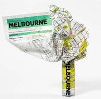
Melbourne Crumpled City Map

Melbourne Crumpled City Map from a collection of street plans of major cities printed on soft, very lightweight (approximately only 20g) and yet extremely tear-resistant and 100% waterproof material, specifically designed to be scrunched and crammed into pockets, handbags and backpacks, either on its own or in the pouch from the same material provided with each map. Creases are a fully intentional part of the quirkiness of the Crumpled City maps – the more battered they are they better they look.Parks and other green spaces are highlighted, as are metro stations, and important buildings are named. Each map also highlights 10 recommended “soulsights”, imaginatively chosen to present the essence of each city rather than the most obvious tourist destinations. The accompanying
index placed next to the map lists locations of tourist interest: selected streets and squares, monuments and historical places, museums and galleries, parks, etc. Whilst cartographically these Crumpled City maps provide perhaps not the most precise representation of the street network, they are handy for sightseeing, light and durable, can be used as a table cloth when picnicking in the Luxembourg Gardens, Hyde Park, the Retiro or the Central Park, or just as an unusual decoration… Selected cities are also presented on more colourful ‘junior’ maps, specially designed for children. Drawings highlight not only important buildings and famous locations but also places which will specifically appeal to children: toy shops, bookshops, best ice cream, etc. Each title has a
list of the recommended not-to-be missed locations with addresses and, where available, websites.To see the full list of cities covered by this unique series please click on the series link.
RIP - This product is no longer available on our network. It was last seen on 25.09.2019

This page now acts as a permanent archive for this product. Add more information using the comments box below to ensure it can still be found by future generations.

Use our search facility to see if it is available from an alternative contributor.
  • Availability: Out Of Stock
  • Supplier: Stanfords
  • SKU: 9788897487173
Availability: In Stock
£10.00

Product Description

Melbourne Crumpled City Map from a collection of street plans of major cities printed on soft, very lightweight (approximately only 20g) & yet extremely tear-resistant & 100% waterproof material, specifically designed to be scrunched & crammed into pockets, handbags & backpacks, either on its own or in the pouch from the same material provided with each map. Creases are a fully intentional part of the quirkiness of the Crumpled City maps – the more battered they are they better they look. Parks & other green spaces are highlighted, as are metro stations, & important buildings are named. Each map also highlights 10 recommended “soulsights”, imaginatively chosen to present the essence of each city rather than the most obvious tourist destinations. The accompanying index placed next to the map lists locations of tourist interest: selected streets & squares, monuments & historical places, museums & galleries, parks, etc. Whilst cartographically these Crumpled City maps provide perhaps not the most precise representation of the street network, they are handy for sightseeing, light & durable, can be used as a table cloth when picnicking in the Luxembourg Gardens, Hyde Park, the Retiro or the Central Park, or just as an unusual decoration… Selected cities are also presented on more colourful ‘junior’ maps, specially designed for children. Drawings highlight not only important buildings & famous locations but also places which will specifically appeal to children: toy shops, bookshops, best ice cream, etc. Each title has a list of the recommended not-to-be missed locations with addresses &, where available, websites. To see the full list of cities covered by this unique series please click on the series link.

Reviews/Comments

Add New

Intelligent Comparison

Oooops!
We couldn't find anything!
Perhaps this product's unique.... Or perhaps we are still looking for comparisons!
Click to bump this page and we'll hurry up.

Price History

Vouchers

No voucher codes found.
Do you know a voucher code for this product or supplier? Add it to Insights for others to use.

Facebook

Jargon Buster

Ice - Frozen water, the solid state of water.
Toy - A generic term for something that can be played with for enjoyment
Pockets - A small bag to carry items usually sewn on the side of garments
soft - A descriptive word for an item/sound which is gentle to the touch or ears
Waterproof - Resistant to water, usualy specified by depth in metres
Network - A link and communication between things. Often computers or people.
Ice - Frozen water, Ice is cold to the touch and forms when water reaches 0 degrees centigrade.
Unusual - Something unique and different.
Resistant - Something that can repel against something.
Precise - A measurement on the accuracy of something
Children - A young life form within the early stages of physical development,
Cream - A warmer tone of white, also a thick white/yellow food liquid used in cooking.

Supplier Information

Stanfords
Stanfords was established in 1853 and opened their iconic Covent Garden flagship store in 1901. They have become the top retailer of maps, travel books and accessories in the UK and arguably offer the largest selection of maps and travel books worldwide. Famous names such as Captain Robert Falcon Scott, Ranulph Fiennes and Michael Palin have purchased from Stanfords. They now have a shop in Bristol and both stores together with other venues operate a calendar of events including talks, book signings and exhibitions. As a specialist map retailer, the map selection is comprehensive and includes road maps, street maps and walking maps from worldwide destinations, as well as a selection of world atlases and wall maps. Books include travel guides and travel literature. Stanfords also stock globes, from miniatures made of blue marble to magnificent floor-standing globes. The website features a selection of interesting articles on travel topics.
Page Updated: 2023-11-12 20:15:36

Community Generated Product Tags

Oh No! The productWIKI community hasn't generated any tags for this product yet!
Menu