
 United Kingdom
 France
 Germany
 Netherlands
 Sweden
 USA
USA
 Italy
Italy
 Spain
Spain
More From Contributor


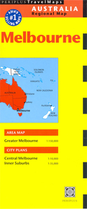
Melbourne (2005 Edition)
Melbourne on a double-sided, indexed map from Periplus. Includes an overview of Greater Melbourne, an enlarged plan of its inner suburbs and a detailed plan of the city centre. Suitable for tourism and business.Greater Melbourne is shown at 1:150, 000 and details the railway lines, motorways (with route numbers) and many of the city`s main approach roads. Shows Melbourne Airport. Nearby parks and attractions are highlighted. The city`s districts are clearly named.The Inner Suburbs at 1:35, 000 names many more minor roads and provides greater detail of the rail network, parks and gardens.Central Melbourne is shown at 1:10, 000, with car parks and one-way streets, additional sites of interest to tourists and businesspeople, and many restaurants, hotels, etc.
 "Pin It")
Product Description
Reviews/Comments
Add New
Vouchers
No voucher codes found.
Do you know a voucher code for this product or supplier? Add it to Insights for others to use.
Do you know a voucher code for this product or supplier? Add it to Insights for others to use.
 Denmark