More From Contributor

£12.99
Map No. 1239 bis, Müstair, in the topographic survey of Switzerland at 1:25, 000 from Bundesamt für Landestopographie (swisstopo), covering the whole country on 247 small format sheets, with special larger maps published for popular regions including some titles now available in hiking versions. Highly regarded for their superb use of graphic relief & hill shading, the maps give an almost 3-D picture of Switzerland`s mountainous terrain. Contours are at 10 m intervals, with 20m intervals in the mountainous areas. All the maps have a 1-km grid for Swiss national coordinates (datum CH 1903). * Small format sheets (Nos. 1011
- 1374)* Map legend in the language of the area covered by the map. Additional margin ticks show latitude & longitude in steps of 2`. The area covered by each map is 17 x 12 km (11 x 7 miles approx). * Special larger sheets (Nos. from 2501 onwards) – STANDARD editions:* No map legend is included but a separate leaflet can be provided instead. The area covered by each map is 25 x 17 km (15 x 11 miles approx).* Special larger sheets (Nos. from 2501 onwards) – HIKING editions:* An overprint highlights hiking, mountain & alpine paths, including regional & national long-distance trails. The maps also show bus routes with bus stops, plus inns in remote locations. The area covered by each map is 25 x 17 km (15 x 11 miles approx).
...
Archived Product
£14.99
Mýrar, map no. 2, in the topographic survey of Iceland at 1:100, 000 published by Mál og menning, with excellent, vivid presentation of the terrain, footpaths & bridleways, campsites, etc. The maps have contours at 20m intervals, enhanced by bold relief shading plus colouring and/or graphics to show glaciers, lava fields, sands & mudflats, as well as to distinguish land with vegetation cover from the more sparsely covered terrain. The series provides a splendid presentation of the country’s topography, with large amount of detail & over 43, 000 place names. Road network indicates gravel roads &

Includes::
country tracks. Also marked are local footpaths, clear to see with their distinctive colouring, & bridleways. Symbols shows campsites, tourist huts or shelters, emergency shelters, summer houses, river fords, golf courses & swimming pools, hydro-electric or thermal power stations, local airports, etc, & detail such as individual farms, abandoned farms or ruins, sheepfolds, etc. Each map covers an area of 84 x 67km (53 x 42 miles approx.) & has latitude & longitude lines drawn at intervals of 2’ & 5’ respectively. Map legend

Includes::
English, German & French. To see the other titles in this series please click on the series link.


...
Archived Product
£14.99
Mýrdalsjökull
- Eyjafjallajökull, map no. 14, in the topographic survey of Iceland at 1:100, 000 published by Mál og menning,
...
Archived Product
£14.99
Mývatnsöræfi, map no. 21, in the topographic survey of Iceland at 1:100, 000 published by Mál og menning, with excellent, vivid presentation of the terrain, footpaths & bridleways, campsites, etc. The maps have contours at 20m intervals, enhanced by bold relief shading plus colouring and/or graphics to show glaciers, lava fields, sands & mudflats, as well as to distinguish land with vegetation cover from the more sparsely covered terrain. The series provides a splendid presentation of the country’s topography, with large amount of detail & over 43, 000 place names. Road network indicates gravel roads &

Includes::
country tracks. Also marked are local footpaths, clear to see with their distinctive colouring, & bridleways. Symbols shows campsites, tourist huts or shelters, emergency shelters, summer houses, river fords, golf courses & swimming pools, hydro-electric or thermal power stations, local airports, etc, & detail such as individual farms, abandoned farms or ruins, sheepfolds, etc. Each map covers an area of 84 x 67km (53 x 42 miles approx.) & has latitude & longitude lines drawn at intervals of 2’ & 5’ respectively. Map legend

Includes::
English, German & French. To see the other titles in this series please click on the series link.


...
Archived Product
£29.99
Map No. 2630, Mbabane, in South Africa’s official topographic survey at 1:250, 000 from the country’s national survey organization, the Chief Directorate of Surveys & Mapping. The maps have altitude colouring & contours at 50m or 100m intervals, depending on the map edition, plus spot heights. Deserts, marshes, dry pans, perennial & seasonal water features, etc, as well as protected areas are shown. The maps present the country’s road & rail networks & include the usual information expected on topographic mapping at this scale, although in more rapidly developing areas road information may not necessarily be up to date. Also indicated are magisterial district & provincial boundaries. Latitude & longitude values are shown in the margins at 5` intervals together with South African grid co-ordinates. Typically, each sheet covers an area of one degree of latitude & two degrees of longitude. The projection used is Gauss Conformal. The legend is in English & Afrikaans. ...
Archived Product
£12.00
Essential for all vessels who wish to enter an Emission Control Area, at berth in a United Kingdom port, a UK passenger ship operating in UK waters, controlled waters, & any other passenger ship which calls at a port in the UK.` The Merchant Shipping (Prevention of Air Pollution from Ships) Regulation 2008`, as amended, require the master of a ship
- to which the regulation apply
- to make a record to demonstrate compliance for any ship using separate fuel oils & make a record of any fuel changeover operation.

...
Archived Product
£16.00
The Ballast Water Record Book is to be used on board all vessels to record intake & discharge of ballast water. The International Convention for the Control & Management of Ships` Ballast Water & Sediments (BWM Convention) will enter into force on 8 September 2017. Under the Convention, all ships in international traffic are required to manage their ballast water & sediments to a certain standard, according to a ship-specific ballast water management plan. All ships will also have to carry a ballast water record book & an international ballast water management certificate. ...
Archived Product
£3.00
The Official Log Book provides 76 pages of log entry space in a grid-table format. Each page contains entry space for: Reference number in list of crew, Name of seamen, Capacity in which employed, If entry made in narrative section give relevant page, reference number in list of crew, name of seamen capacity in which employed, if entry made in narrative section give relevant page. ...
Archived Product
£12.00
` Oil Record Book (Part II): Cargo / Ballast Operations (Oil Tankers)` is required in accordance with regulation 36 of Annex I of the International Convention for the Prevention of pollution from Ships (1973), as modified by the Protocol of 1978 (MARPOL 73/78). The ` Oil Record Book (Part I): Machinery Space operations (All Ships)` is available to purchase separately, please search by ISBN 9780115531569. ...
Archived Product
£12.00
` Oil Record Book (Part I): Machinery Space Operations (All Ships)` is required to record Machinery Space Operations for every ship of over 400 tons gross tonnage (other than oil tankers) & every oil tanker over the 150 tons gross tonnage. This is a vital record book, required in accordance with regulation 17 of the International Convention for the Prevention of Pollution from Ships (1973), as modified by the Protocol of 1978 (MARPOL73/78). The ` Oil Record Book (Part II): Cargo/ Ballast Operations (Oil Tankers)` is available to purchase separately. Please search by ISBN 9780115531576. ...
Archived Product

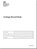
MCA Garbage Record Book

This amended Garbage Record Book is to be used on board vessels to record discharges from and incinerations on board ships. It contains the latest guidance in accordance with regulation 10 of Annex V of the International Convention for the Prevention of Pollution from Ships, 1973, as modified by the Protocol of 1978 (MARPOL), a record is to be kept of each discharge operation or completed by incineration. This includes discharges into the sea, to reception facilities, or to other ships, as well as the accidental loss of garbage.MARPOL Annex V - Garbage has been revised to strengthen the current provisions so to continue to reduce pollution caused by garbage. This amended book helps you to meet the new requirements which include:Additional garbage typesDifferent requirements in
respect of discharge conditionsReporting
RIP - This product is no longer available on our network. It was last seen on 25.09.2019

This page now acts as a permanent archive for this product. Add more information using the comments box below to ensure it can still be found by future generations.

Use our search facility to see if it is available from an alternative contributor.
  • External links may include paid for promotion
  • Availability: Out Of Stock
  • Supplier: Stanfords
  • SKU: 9780115535680
Availability: In Stock
£12.00

Product Description

This amended Garbage Record Book is to be used on board vessels to record discharges from & incinerations on board ships. It contains the latest guidance in accordance with regulation 10 of Annex V of the International Convention for the Prevention of Pollution from Ships, 1973, as modified by the Protocol of 1978 (MARPOL), a record is to be kept of each discharge operation or completed by incineration. This

Includes::
discharges into the sea, to reception facilities, or to other ships, as well as the accidental loss of garbage.MARPOL Annex V
- Garbage has been revised to strengthen the current provisions so to continue to reduce pollution caused by garbage. This amended book helps you to meet the new requirements which include: Additional garbage types Different requirements in respect of discharge conditions Reporting

Reviews/Comments

Add New

Intelligent Comparison

Oooops!
We couldn't find anything!
Perhaps this product's unique.... Or perhaps we are still looking for comparisons!
Click to bump this page and we'll hurry up.

Price History

Vouchers

No voucher codes found.
Do you know a voucher code for this product or supplier? Add it to Insights for others to use.

Facebook

Jargon Buster

Reception - An atmosphere from a group of people, a radio sound frequency quality.

Supplier Information

Stanfords
Stanfords was established in 1853 and opened their iconic Covent Garden flagship store in 1901. They have become the top retailer of maps, travel books and accessories in the UK and arguably offer the largest selection of maps and travel books worldwide. Famous names such as Captain Robert Falcon Scott, Ranulph Fiennes and Michael Palin have purchased from Stanfords. They now have a shop in Bristol and both stores together with other venues operate a calendar of events including talks, book signings and exhibitions. As a specialist map retailer, the map selection is comprehensive and includes road maps, street maps and walking maps from worldwide destinations, as well as a selection of world atlases and wall maps. Books include travel guides and travel literature. Stanfords also stock globes, from miniatures made of blue marble to magnificent floor-standing globes. The website features a selection of interesting articles on travel topics.
Page Updated: 2023-11-12 20:15:36

Community Generated Product Tags

Oh No! The productWIKI community hasn't generated any tags for this product yet!
Menu