More From Contributor
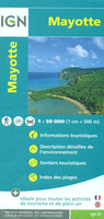
£8.25
Map No. 37, Mayo South-West
- Galway North-West, in the Discovery series from the OSI, the Ordnance Survey of Irel&, which
...
Archived Product
£8.25
Map No. 30, Mayo West-Central in the Discovery series from the OSI, the Ordnance Survey of Irel&, which presents the country on detailed topographic maps at 1:50, 000, with additional overprint highlighting campsites & caravan parks, youth hostels, etc. The maps have contours at 10m intervals, with plenty of spot heights & additional altitude colouring. Graphics indicate different types of woodlands. An overprint highlights waymarked or unmarked walking trails as well as cycle routes. National or forest parks & nature reserves are marked & a range of symbols provide tourist information: campsites, caravan parks, youth hostels (An ...
Archived Product
£8.25
Map No. 30, Mayo West-Central in the Discovery series from the OSI, the Ordnance Survey of Irel&, which presents the country on detailed topographic maps at 1:50, 000, with additional overprint highlighting campsites & caravan parks, youth hostels, etc. Current 4th edition of this title was published in February 2011. Maps in the Discovery series have contours at 10m intervals, with plenty of spot heights & additional altitude colouring. Graphics indicate different types of woodlands. An overprint highlights waymarked or unmarked walking trails as well as cycle routes. National or forest parks & nature reserves are marked & a range of symbols provide tourist information: campsites, caravan parks, youth hostels (An Óige & independent), tourist offices, parking & picnic places, & viewpoints. Golf courses indicate the number of holes. The maps also highlight antiquities & historical sites such as megalithic tombs, standing stones, battlefields, etc. Road network grades third class roads according to their widths &

Includes::
local tracks. Railways are shown with stations & the maps include other details expected of topographic mapping at this scale. Where appropriate, place names are given in both Irish & English. Each map covers an area of 40 x 30km (25 x 19 miles approximately) & has a 1km ITM (Irish Transverse Mercator) grid, plus latitude & longitude margin ticks at 1` intervals. Map legend is in Irish & English. To see the list of all the titles in this series please click on the series link.

...
Archived Product
£1.99
None of the great Victorian novels is more vivid & readable than The Mayor of Casterbridge. Set in the heart of Hardy`s Wessex, the `partly real, partly dream country` he founded on his native Dorset, it charts the rise & self-induced downfall of a single `man of character`. The fast-moving & ingeniously contrived narrative is Shakespearian in its tragic force, & features some of the author`s most striking episodes & brilliant passages of description. ...
Archived Product
£12.95
Detailed map with the same specifications as the topographic survey of France: contours at 20m intervals & bold relief shading. The map indicates various types of vegetation & shows special forest reserves. Road information

Includes::
seasonal tracks & footpaths. Latitude & longitude are shown by a grid at 5' intervals, & UTM co-ordinates by cross ticks every 5km. Map legend is in French only.

...
Archived Product
£19.99
This book offers insight into the part played by superstition in British history
- the omens & beliefs that have guided kings &
...
Archived Product
£9.50
Map No. 037, Mayrhofen
- Tuxer Tal
- Zillergrund
- Zillertal Alps, with a booklet which

Includes::


...
Archived Product
£9.99
Mayrhofen
- Zillertal Alps
- Gerlos
- Krimml
- Tuxertal
- Zell im Zillertal area of the Austrian Alps presented at


...
Archived Product
£6.50
Topographic coverage of mainland Spain at 1:25, 000 published by the Centro Nacional de Información Geograficá, the country’s civilian survey organization. The maps have contours at 10m intervals & colouring and/or graphics to show different types of vegetation or land use. Boundaries of national parks & other protected areas are marked. In addition to all the usual information shown on topographic maps at this scale, detailed presentation of the road & rail networks, rural tracks & paths, etc, the maps also show campsites. The maps have a 1-km UTM grid, with margin ticks for latitude & longitude at 1` intervals. Map legend is in Spanish only.PLEASE NOTE: our grid for the whole of Spain is in preparation
- in the meantime, for areas other than those shown on the attached grid please use CNIG’s topographic survey at 1:50, 000 by searching for ‘SI00000832’. Each 25K map covers one quarter of the corresponding 50K map, with the numbering system: I = NW quarter, II = NE quarter, III = SW quarter & IV = SE quarter. CNIG maps in the Provincial Road Maps series at 1:200, 000 are overprinted with the grid for the 1:50, 000 survey & can be used to see the area covered by each 50K or 25K title in more detail. To see the list of titles in this series please click on the series grid
- for map numbers not yet listed on our website please contact us by email.

...
Archived Product
£24.95
Road map of this province on the coast of the Caspian Sea. The larger towns are named in Farsi & Roman script, with smaller places in Farsi only. Road surfaces are shown, with petrol stations & places of interest. Relief is shown by elevation colouring. The map also

Includes::
a distance table (in Farsi & Roman script) & street plans (in Farsi only).

...
Archived Product

Mayotte IGN Map

Mayotte at 1:50, 000 on a contoured and GPS compatible map from the IGN, with plans of Mazoudzou and Dzaoudzi, plus an index of beaches. Topography is shown by contours at 20m intervals with relief shading and spot heights, plus colouring and/or graphics for different types of vegetation. In the surrounding waters coral reefs are prominently shown.Road network indicates unsurfaced roads and includes local tracks and paths. An overprint highlights the course of the GR1 – Tour de Mayotte long-distance footpaths, with symbols marking various facilities and places of interest, including different types of tourist accommodation, local markets, beaches, marinas and water sports sites, golf courses, cultural heritage, etc. The map has a 10km UTM grid, plus latitude and longitude
lines at 5’ intervals. Map legend includes English.In addition to an index of beaches, aerial photos with names of main streets and symbols for various facilities cover Mazoudzou and Dzaoudzi.
RIP - This product is no longer available on our network. It was last seen on 25.09.2019

This page now acts as a permanent archive for this product. Add more information using the comments box below to ensure it can still be found by future generations.

Use our search facility to see if it is available from an alternative contributor.
  • External links may include paid for promotion
  • Availability: Out Of Stock
  • Supplier: Stanfords
  • SKU: 9782758534884
Availability: In Stock
£11.99

Product Description

Mayotte at 1:50, 000 on a contoured & GPS compatible map from the IGN, with plans of Mazoudzou & Dzaoudzi, plus an index of beaches. Topography is shown by contours at 20m intervals with relief shading & spot heights, plus colouring and/or graphics for different types of vegetation. In the surrounding waters coral reefs are prominently shown. Road network indicates unsurfaced roads &

Includes::
local tracks & paths. An overprint highlights the course of the GR1 – Tour de Mayotte long-distance footpaths, with symbols marking various facilities & places of interest, including different types of tourist accommodation, local markets, beaches, marinas & water sports sites, golf courses, cultural heritage, etc. The map has a 10km UTM grid, plus latitude & longitude lines at 5’ intervals. Map legend

Includes::
English. In addition to an index of beaches, aerial photos with names of main streets & symbols for various facilities cover Mazoudzou & Dzaoudzi.

Reviews/Comments

Add New

Intelligent Comparison

Oooops!
We couldn't find anything!
Perhaps this product's unique.... Or perhaps we are still looking for comparisons!
Click to bump this page and we'll hurry up.

Price History

Vouchers

No voucher codes found.
Do you know a voucher code for this product or supplier? Add it to Insights for others to use.

Facebook

Jargon Buster

GPS - Global Positioning System - Global position using satellites
water - A chemical substance. Chemical formula H2O.
Graphics - A general term for visual aspects of an item/display
Network - A link and communication between things. Often computers or people.
Road - a manmade lane or a path that is used to speed up travel.
Golf - A sport played on a large outside grass course, the aim to hit a small ball with a club into small holes.
Accommodation - A room in which someone can live in, for example in a hotel

Supplier Information

Stanfords
Stanfords was established in 1853 and opened their iconic Covent Garden flagship store in 1901. They have become the top retailer of maps, travel books and accessories in the UK and arguably offer the largest selection of maps and travel books worldwide. Famous names such as Captain Robert Falcon Scott, Ranulph Fiennes and Michael Palin have purchased from Stanfords. They now have a shop in Bristol and both stores together with other venues operate a calendar of events including talks, book signings and exhibitions. As a specialist map retailer, the map selection is comprehensive and includes road maps, street maps and walking maps from worldwide destinations, as well as a selection of world atlases and wall maps. Books include travel guides and travel literature. Stanfords also stock globes, from miniatures made of blue marble to magnificent floor-standing globes. The website features a selection of interesting articles on travel topics.
Page Updated: 2023-11-12 20:15:36

Community Generated Product Tags

Oh No! The productWIKI community hasn't generated any tags for this product yet!
Menu