More From Contributor
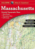
£19.95
Clear street plan by the country`s official survey department. Detail

Includes::
railways, major power lines,

...
Archived Product
£8.99
Passionate, talented, headstrong & ambitious, Masha takes the European film scene by storm, escaping her small provincial town to become the most daring, avant-garde auteur of her generation. Taking inspiration from her personal life as well as the artists & poets she meets on the streets of St Petersburg, Masha courageously puts herself on the line by transforming her own experiences into art. But as painful memories of her childhood start to resurface, she is forced to confront her demons
- the betrayals, the cruelties
- in this psychologically compelling debut from one of Russia`s most exciting young writers.

...
Archived Product
£3.50
Masham in 1928 in a fascinating series of reproductions of old Ordnance Survey plans in the Alan Godfrey Editions, ideal for anyone interested in the history of their neighbourhood or family. The map covers the small market town of Masham, including Well Garth Brewery, auction mart, Market Place, St Mary`s church, Millgate, railway branch & terminus with a mineral line continuing beyond, River Ure. A 1905 directory of Masham is on the reverse. About the Alan Godfrey Editions of the 25” OS Series: Selected towns in Great Britain & Ireland are covered by maps showing the extent of urban development in the last decades of the 19th & early 20th century. The plans have been taken from the Ordnance Survey mapping & reprinted at about 15 inches to one mile (1:4, 340). On the reverse most maps have historical notes & many also include extracts from contemporary directories. Most maps cover about one mile (1.6kms) north/south, one & a half miles (2.4kms) across; adjoining sheets can be combined to provide wider coverage.FOR MORE INFORMATION & A COMPLETE LIST OF ALL AVAILABLE TITLES PLEASE CLICK ON THE SERIES LINK. ...
Archived Product
£24.95
A street plan of Mashhad is on one side of the sheet with names of major streets marked in English & Persian on map, museums, historical monuments, hotels, public buildings, mosques & churches; on the reverse, only in Persian, is a brief guide to the history & to the major attractions in & around the city, a classified index including monuments, hotels, hospitals & chemists among other things & a glossary of useful terms. ...
Archived Product
£7.95
Massa
- Carrara Province in a series of handy size road maps from Litografia Artistica Cartografica (LAC) with more minor local
...
Archived Product
£3.99
Massachusetts Biking in the Moon Spotlight guide series; covering a range of specific local cities, districts, areas & regions in North, Central & South America & targeted at those seeking to travel to a specific area within a country. Each of the guides has been extracted in full from the relevant country Moon Handbook & individual titles focus on a particular city, region or notable area of the destination. Many of the guides in the series are unique in their coverage, although are limited in putting the destination into its wider geographical context that a more comprehensive guide would provide. Stylistically, Moon ...
Archived Product
£9.99
Massachusetts on a laminated & waterproof Easy-to-Fold map from Rand Mc Nally, the country’s leading publisher of road maps & street plans. For clarity of road information Rand Mc Nally state maps present the road network on a plain background, with no or little topographic detail. Driving distances are indicated on all principal highways & on many local routes. National or state parks & other protected areas, Indian Reservations & restricted entry military zones are highlighted & symbols indicate campsites, rest areas, various places of interest, etc. Each map shows local administrative boundaries with names of the counties, is indexed & gives geographical coordinates as margin ticks usually at 1° intervals. Rand Mc Nally state maps are available in two formats: double-sided Easy-to-Read maps with numerous enlargements for cities and/or most visited areas, & laminated Easy-to-Fold maps in a more handy format but with smaller print. TO SEE THE LIST OF RAND Mc NALLY STATE MAPS PLEASE CLICK ON THE SERIES LINK. ...
Archived Product
£6.99
Massachusetts Easy-to-Read map from Rand Mc Nally, US leading publisher of road maps & street plans, in their extensive series of state maps. Additional panels provide enlargements for: Boston & vicinity with a plan of downtown Boston, Cap Cod National Sea Shore, New Bedford
- Fall River, Lowell
- Lawrence
- the Merrimack Valley Cities, Pittsville, Springfield & Worcester. For clarity of road information Rand Mc Nally state maps present the road network on a plain background, with no or little topographic detail. Driving distances are indicated on all principal highways & on many local routes. National or state parks & other protected areas, Indian Reservations & restricted entry military zones are highlighted & symbols indicate campsites, rest areas, various places of interest, etc. Each map shows local administrative boundaries with names of the counties, is indexed & gives geographical coordinates as margin ticks usually at 1° intervals. Rand Mc Nally state maps are available in two formats: double-sided Easy-to-Read maps with numerous enlargements for cities and/or most visited areas, & laminated Easy-to-Fold maps in a more handy format but with smaller print. TO SEE THE LIST OF RAND Mc NALLY STATE MAPS PLEASE CLICK ON THE SERIES LINK.


...
Archived Product
£4.99
Massachusetts Hiking in the Moon Spotlight guide series; covering a range of specific local cities, districts, areas & regions in North, Central & South America & targeted at those seeking to travel to a specific area within a country. Each of the guides has been extracted in full from the relevant country Moon Handbook & individual titles focus on a particular city, region or notable area of the destination. Many of the guides in the series are unique in their coverage, although are limited in putting the destination into its wider geographical context that a more comprehensive guide would provide. Stylistically, Moon ...
Archived Product
£19.99
Massachusetts Recreational Atlas & Gazetteer at 1:80, 000 approx. in a series of large format paperback state atlases from De Lorme, with detailed, contoured, GPS compatible topographic mapping, plus indexed street plans of the Boston conurbation, Springfield & Worcester. Recreational information

Includes::
lists of unique natural features, historic sites & attractions, scenic drives. Tables are also provided listing, where appropriate with facilities, campgrounds, hiking trails, wildlife viewing sites, recreational areas, fishing & hunting areas, paddling sites, downhill & cross-country skiing sites, golf courses. Each title in this De Lorme series covers one state & presents it at a scale much more detailed than used on most state road maps. Particularly popular areas are often also presented on enlargements. The maps are contoured, show variation of terrain (deserts, glaciers, wetlands, woodlands, etc) & have latitude & longitude and/or UTM grid lines for GPS use. Various types of protected areas are distinguished by the colouring of their boundaries, e.g. national or state parks, forests, etc. Also marked are Indian Reservations & restricted entry military zones. Road network is shown in much more detail than on other state mapping, with local roads, unsurfaced back roads & tracks, forest trails, etc. Where appropriate, old historical routes are marked. Railway lines & local airports or landing strips are included & the maps also indicate administrative boundaries. Symbols highlight various recreational areas & facilities such as campgrounds, unique natural features, etc. Each title contains extensive lists of outdoor adventure sites (grouped into activities such as hiking, biking, paddling, fishing, skiing, etc.), diverse family outing sites, campgrounds, & tables showing what facilities can be found in the state’s recreational areas. Each atlas also has an index of localities. To see the list of titles in this series please click on the series link.

...
Archived Product

Massachusetts

Massachusetts in a series of US state maps from the National Geographic with cartography from Mapquest. City maps and enlargements cover the Boston conurbation with a street plan of downtown Boston, Lovell, Worcester, New Bedford - Fall River, Springfield, Providence RI, and Cape Cod, plus a scenic drive tour of the Berkshire Hills. The map is printed on lightweight, waterproof and tear-resistant plastic paper. Maps in the NGS State Series clearly show each state
RIP - This product is no longer available on our network. It was last seen on 25.09.2019

This page now acts as a permanent archive for this product. Add more information using the comments box below to ensure it can still be found by future generations.

Use our search facility to see if it is available from an alternative contributor.
  • External links may include paid for promotion
  • Availability: Out Of Stock
  • Supplier: Stanfords
  • SKU: 9781597750912
Availability: In Stock
£8.50

Product Description

Massachusetts in a series of US state maps from the National Geographic with cartography from Mapquest. City maps & enlargements cover the Boston conurbation with a street plan of downtown Boston, Lovell, Worcester, New Bedford
- Fall River, Springfield, Providence RI, & Cape Cod, plus a scenic drive tour of the Berkshire Hills. The map is printed on lightweight, waterproof & tear-resistant plastic paper. Maps in the NGS State Series clearly show each state

Reviews/Comments

Add New

Intelligent Comparison

Oooops!
We couldn't find anything!
Perhaps this product's unique.... Or perhaps we are still looking for comparisons!
Click to bump this page and we'll hurry up.

Price History

Vouchers

No voucher codes found.
Do you know a voucher code for this product or supplier? Add it to Insights for others to use.

Facebook

Jargon Buster

Paper - A thin sheet mainly used for writing. Available in a variety of colours. Made mainly from wood pulp.
Plastic - A generic term for a synthetic product used in the manufacture of products
Waterproof - Resistant to water, usualy specified by depth in metres
Resistant - Something that can repel against something.

Supplier Information

Stanfords
Stanfords was established in 1853 and opened their iconic Covent Garden flagship store in 1901. They have become the top retailer of maps, travel books and accessories in the UK and arguably offer the largest selection of maps and travel books worldwide. Famous names such as Captain Robert Falcon Scott, Ranulph Fiennes and Michael Palin have purchased from Stanfords. They now have a shop in Bristol and both stores together with other venues operate a calendar of events including talks, book signings and exhibitions. As a specialist map retailer, the map selection is comprehensive and includes road maps, street maps and walking maps from worldwide destinations, as well as a selection of world atlases and wall maps. Books include travel guides and travel literature. Stanfords also stock globes, from miniatures made of blue marble to magnificent floor-standing globes. The website features a selection of interesting articles on travel topics.
Page Updated: 2023-11-12 20:15:36

Community Generated Product Tags

Oh No! The productWIKI community hasn't generated any tags for this product yet!
Menu