More From Contributor

£19.99
Maryland & Delaware Recreational Atlas & Gazetteer at 1:100, 000 approx. in a series of large format paperback state atlases from De Lorme, with detailed, contoured, GPS compatible topographic mapping. Additional maps provide information on the ecology of the Chesapeake Bay, showing habitats of blue crab, eastern oyster, plus hard & soft shell clam. Recreational information

Includes::
lists of unique natural features, hiking & biking trails, historic sites, museums, gardens, scenic drives, Chesapeake Bay lighthouses. Tables are also provided listing, where appropriate with facilities, state & national lands, campgrounds, canoeing sites, plus fishing sites each with a list of species. Each title in this De Lorme series covers one state & presents it at a scale much more detailed than used on most state road maps. Particularly popular areas are often also presented on enlargements. The maps are contoured, show variation of terrain (deserts, glaciers, wetlands, woodlands, etc) & have latitude & longitude and/or UTM grid lines for GPS use. Various types of protected areas are distinguished by the colouring of their boundaries, e.g. national or state parks, forests, etc. Also marked are Indian Reservations & restricted entry military zones. Road network is shown in much more detail than on other state mapping, with local roads, unsurfaced back roads & tracks, forest trails, etc. Where appropriate, old historical routes are marked. Railway lines & local airports or landing strips are included & the maps also indicate administrative boundaries. Symbols highlight various recreational areas & facilities such as campgrounds, unique natural features, etc. Each title contains extensive lists of outdoor adventure sites (grouped into activities such as hiking, biking, paddling, fishing, skiing, etc.), diverse family outing sites, campgrounds, & tables showing what facilities can be found in the state’s recreational areas. Each atlas also has an index of localities. To see the list of titles in this series please click on the series link.

...
Archived Product
£3.99
Maryland's Eastern Shore in the Moon Spotlight guide series; covering a range of specific local cities, districts, areas & regions in North, Central & South America & targeted at those seeking to travel to a specific area within a country. Each of the guides has been extracted in full from the relevant country Moon Handbook & individual titles focus on a particular city, region or notable area of the destination. Many of the guides in the series are unique in their coverage, although are limited in putting the destination into its wider geographical context that a more comprehensive guide would provide. Stylistically, Moon ...
Archived Product
£8.50
About this series Bypassing the major cities almost completely, this series of regional guides concentrates on the hinterlands & backwoods of the USA. Specifically intended for drivers & family oriented, these titles highlight local museums, historical sights & nature trails. There are also recommendations for shopping, lodging & eating. Illustrated with some line drawings. ...
Archived Product
£12.99
This fascinating collection of over 200 images takes is on a tour of the old borough of Marylebone, from Oxford Street to Edgware Road & from Baker Street to St John`s Wood. They sketch Marylebone`s history as one of London`s smaller metropolitan areas which, in 1965, amalgamated with nearby Westminster & Paddington to form the City of Westminster. This selection was compiled mainly from private collections with contributions from Marylebone Gallery & London Metropolitan Archives. It depicts the social & commercial life of this distinctive area, showing familiar attractions such as Madame Tussaud`s & Lord`s Cricket Ground as well as fine Georgian houses, busy thoroughfares, long-vanished Underground statiosn & well-known shops. This unique collection of photgraphs, many of which appear in print for the first time, will jog the memory & stimulate the imagination of old & young, residents & visitors alike. ...
Archived Product
£15.95
Marylebone is a place of contrasts. Georgian terraces interspersed with Arts & Crafts re-builds, the formal & wild gardens of Regent`s Park, & the renascent chic of Marylebone High Street leading south to the grand emporia of Oxford Street. Not to mention the `medical quarter` around Harley Street. The famous landmarks include the glorious Langham Hotel, Broadcasting House, Wigmore Hall, the Wallace Collections, Selfridge`s, RIBA &, of course, Madame Tussauds. & lets not forget the former notorious gallows at Tyburn. ...
Archived Product
£2.95
Maryport in 1900 in a fascinating series of reproductions of old Ordnance Survey plans in the Alan Godfrey Editions, ideal for anyone interested in the history of their neighbourhood or family. Selected towns in Great Britain & Ireland are covered by maps showing the extent of urban development in the last decades of the 19th & early 20th century. In this title: the map is double-sided. The main map covers most of the town centre & docks, extending from North Street southward to Collins Terrace & Maryport Dock Junction, & from Lawson Street westward to the shore. Features include River Ellen, town centre with individual buildings neatly delineated, St Mary's church, Fleming Square, Market House; LNWR railway with Whitehaven Junction, goods station, engine shed, part of railway station, Dock Branch, many sidings into docks; Ellenborough Colliery, Solway Iron Works, Senhouse Dock, Elizabeth Dock, Glasson, Mote Hill, Old Harbour, North Harbour etc. Sheet 44.04 to the north is included as an insert, including Flour Mill, Parade Ground, Tannery. On the reverse is most of adjacent sheet 45.05 extending coverage eastward to include Ellenborough, Netherton, Netherhall, Kirkborough, All Souls church, eastern part of station, Ewanrigg Hall (at foot of map), Hayborough (at east of map). About the Alan Godfrey Editions of the 25 ...
Archived Product
£6.99
Mary loathes her big, curly, bushy hair & so she chops it all off...and she looks fantastic! Well, at least she thinks so. But her mammy is not convinced & forbids her from ever cutting her own hair again. But she didn`t say anything about anyone else...A brilliant laugh-out-loud Little Gem about a not-so-brilliant hairdresser & one very unfortunate dog! High quality cream paper & a special easy to read font ensure a smooth read for all. ...
Archived Product
£13.50
Written by MARZENA SOWA Art & cover by SYLVAIN SAVOIA ”I am Marzi, born in 1979, ten years before the end of communism in Pol&. My father works at a factory, my mother at a dairy. Social problems are at their height. Empty stores are our daily bread. I`m scared of spiders, & the world of adults doesn`t seem like a walk in the park.” Told from a young girl`s perspective, Marzena Sowa`s memoir of a childhood shaped by politics feels remarkably fresh & immediate. Structured as a series of vignettes that build on one another, MARZI is a compelling & powerful coming-of-age story that portrays the harsh realities of life behind the Iron Curtain while maintaining the everyday wonders & curiosity of childhood. With open & engaging art by Sylvain Savoia, MARZI is a moving & resonant story of an ordinary girl in turbulent, changing times. ...
Archived Product
£8.95
The Mara Triangle is the western third of the Masai Mara National Reserve. The triangle covers 500 square kilometres, lying between the Mara River to the east, the 400m Oloololo Escarpment to the west, & the border with the Serengeti Plains & Tanzania to the south. Colours distinguish the various landscape types eg. grasslands, wetlands, thickets & acacia woods. Hills & significant isolated trees are marked, also seasonal watercourses, tracks, roads, river crossings, reserve gates, lodges, campsites & major migration crossing points on the Mara river. A 1km UTM grid is drawn over the map. A small inset map shows the whole National Reserve. The reverse of the map is devoted to information for vistors: the ecosystem, the annual migrations, practicalities ie, access, campsites, rules for visitors & useful contacts. ...
Archived Product
£26.00
A seminal Indian cookbook that reflects the way we live, cook, entertain & eat today. `A fab book & I believe that its pages will get dirty very soon sitting on the kitchen table` ATUL KOCHHAR` Her style of simple yet delicious Indian recipes will take you on a journey through this extravagant cuisine` DR RUPY AUJLA Food writer Mallika Basu grew up enjoying exotic flavours from across India in an unconventional, bustling home in Kolkata
- & then spent years recreating them in a London kitchen. Now she shares those recipes, techniques & shortcuts so you too can cook wholesome, real Indian food simply. Embrace weekday dinners with lightly spiced fish curry, wok-friendly Goan chilli beef fry or silken kofta curry made with packs of ready-rolled meatballs. For leisurely weekends, tuck into a feast of Vindaloo pulled pork; give your Sunday roast a sumptuous twist with spicy marinades, or enjoy a whole roasted cauliflower encrusted with nut butter. & that`s before you even think about swirling dosa & more for a full-on Indian brunch... Mallika`s recipes respect the past & celebrate the present in an easy & informal way that will broaden your understanding of Indian cooking, & inspire you to return to these simple recipes time & time again.
...
Archived Product

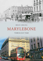
Marylebone Through Time

This compilation of over 180 photographs explores one of inner London`s former Metropolitan Boroughs, and by the use of comparison images reveals some of the changes which have taken place to it in over a century. The particular style of Marylebone`s streets is celebrated here, such as Baker Street, whose fictional detective gained the street worldwide recognition, and Oxford Street, effectively London`s `High Street`. Memories of horse-filled streets and local traders are revived alongside the pubs, concert halls, and transportation of yesteryear to give an intriguing and nostalgic portrait of what is now a characterful part of the modern City of Westminster.
RIP - This product is no longer available on our network. It was last seen on 25.09.2019

This page now acts as a permanent archive for this product. Add more information using the comments box below to ensure it can still be found by future generations.

Use our search facility to see if it is available from an alternative contributor.
  • External links may include paid for promotion
  • Availability: Out Of Stock
  • Supplier: Stanfords
  • SKU: 9781848681453
Availability: In Stock
£14.99

Product Description

This compilation of over 180 photographs explores one of inner London`s former Metropolitan Boroughs, & by the use of comparison images reveals some of the changes which have taken place to it in over a century. The particular style of Marylebone`s streets is celebrated here, such as Baker Street, whose fictional detective gained the street worldwide recognition, & Oxford Street, effectively London`s ` High Street`. Memories of horse-filled streets & local traders are revived alongside the pubs, concert halls, & transportation of yesteryear to give an intriguing & nostalgic portrait of what is now a characterful part of the modern City of Westminster.

Reviews/Comments

Add New

Intelligent Comparison

Oooops!
We couldn't find anything!
Perhaps this product's unique.... Or perhaps we are still looking for comparisons!
Click to bump this page and we'll hurry up.

Price History

Vouchers

No voucher codes found.
Do you know a voucher code for this product or supplier? Add it to Insights for others to use.

Facebook

Jargon Buster

Horse - A large animal with four legs that tends to be ridden.
Nostalgic - A memory for familiar things and wanting to get it back.

Supplier Information

Stanfords
Stanfords was established in 1853 and opened their iconic Covent Garden flagship store in 1901. They have become the top retailer of maps, travel books and accessories in the UK and arguably offer the largest selection of maps and travel books worldwide. Famous names such as Captain Robert Falcon Scott, Ranulph Fiennes and Michael Palin have purchased from Stanfords. They now have a shop in Bristol and both stores together with other venues operate a calendar of events including talks, book signings and exhibitions. As a specialist map retailer, the map selection is comprehensive and includes road maps, street maps and walking maps from worldwide destinations, as well as a selection of world atlases and wall maps. Books include travel guides and travel literature. Stanfords also stock globes, from miniatures made of blue marble to magnificent floor-standing globes. The website features a selection of interesting articles on travel topics.
Page Updated: 2023-11-12 20:15:36

Community Generated Product Tags

Oh No! The productWIKI community hasn't generated any tags for this product yet!
Menu