
 United Kingdom
 France
 Germany
 Netherlands
 Sweden
 USA
USA
 Italy
Italy
 Spain
Spain
More From Contributor


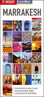
Marrakesh Flexi Map
Marrakesh, with a road map of the High Atlas, on an Insight Flexi Map in their new format introduced to provide more convenient access to the special features of this series: various additional maps and/or street plans plus tourist information including a list of must-see sights. The map is tear-resistant, waterproof, and can be written on with non-permanent marker pens.On one side is the main street plan showing at 1:9, 000 the Medina and the central part of the city. Street index is next to the plan and also includes separate lists of points of interest and hotels. (Please note: the scale is 1:9, 000 as shown on the plan and not 1:15, 000 as indicated on the map cover).On the reverse are this title’s additional features: - A road map covering the Marrakesh region at 1:900, 000,
extending from the coast with Agadir and Essaouira, across the High Atlas with Jbel Toubkal, to beyond Ouarzazate. Topography is indicated by altitude colouring, with symbols for beaches, oasis, campsites, etc. The index includes a list of points of interest.- Brief descriptions of 29 main attractions, neatly grouped into sections covering Souks / Squares / Gates, Museums and Galleries, Palaces and Gardens, Mosques / Madrassas / Shrines, plus Further Afield - all prominently highlighted on the street plan and/or the road map.- Information about Getting Around and Facts for Visitors, including tourist offices, public holidays, opening times, money, tipping, telecommunications and monthly climate charts, as well as notes about health, etiquette and women travellers.To see
the list of other Insight Flexi titles in this series please click on the series link.

Product Description
Reviews/Comments
Add New
Vouchers
No voucher codes found.
Do you know a voucher code for this product or supplier? Add it to Insights for others to use.
Do you know a voucher code for this product or supplier? Add it to Insights for others to use.
 Denmark