
 United Kingdom
 France
 Germany
 Netherlands
 Sweden
 USA
USA
 Italy
Italy
 Spain
Spain
More From Contributor


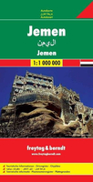
Yemen F&B
Yemen at 1:1, 000, 000 from Freytag & Berndt with a separate booklet attached to the map cover also providing plans showing main streets and districts of Sana’a and Aden. All place names are given in Latin alphabet only.Topography is shown by relief shading, but disappointingly very little topographic information is included when compared with alternative coverage. The map shows the country’s road network, including selected desert tracks, with distances shown on main routes. Locations of border crossing are marked. Also shown are internal administrative boundaries with names of the provinces. The map has latitude and longitude lines at 1° intervals. Multilingual map legend includes English.The index is in a separate booklet attached to the map cover and includes plans of central
Sana’a and Aden, naming main streets, districts and various places of interest.
Sana’a and Aden, naming main streets, districts and various places of interest.

Product Description
Reviews/Comments
Add New
Vouchers
No voucher codes found.
Do you know a voucher code for this product or supplier? Add it to Insights for others to use.
Do you know a voucher code for this product or supplier? Add it to Insights for others to use.
 Denmark