
 United Kingdom
 France
 Germany
 Netherlands
 Sweden
 USA
USA
 Italy
Italy
 Spain
Spain
More From Contributor


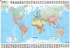

World Michelin Political Folded Map
The Michelin National series World Map is a folded political map in Michelin’s trademark style, with clear & distinct but subtle country colours, and bold, legible but unobtrusive lettering.Capital cities, state/regional capitals and other major cities & towns are marked, with symbols indicating their size. Main road routes between cities are shown. National borders are clearly delimited and major administrative divisions are indicated. The map features flags for all shown countries, along with population, land area & population density information, in strips along the top and bottom. Inset maps show the North and South poles, along with the positions reached by early explorers & expeditions. A further inset map shows international time zones, and side panels show thematic
statistics on climates, mountains and ocean depths.The map uses a modified Van der Griten projection. Grid lines divide the map at 10° intervals with. Principal lines of latitude (tropics & polar circles) are shown.Primarily political in nature, the map shows relatively little physical geographic information, such as land use, climate or vegetation. Rivers are clearly marked, relief shading shows principal topography and some spot heights/depths are given. Approximate extents of summer & winter extents of sea ice. Ocean floor depth is indicated by 3 levels of colouring.A flat wallmap version of this map is also available.
statistics on climates, mountains and ocean depths.The map uses a modified Van der Griten projection. Grid lines divide the map at 10° intervals with. Principal lines of latitude (tropics & polar circles) are shown.Primarily political in nature, the map shows relatively little physical geographic information, such as land use, climate or vegetation. Rivers are clearly marked, relief shading shows principal topography and some spot heights/depths are given. Approximate extents of summer & winter extents of sea ice. Ocean floor depth is indicated by 3 levels of colouring.A flat wallmap version of this map is also available.

Product Description
Reviews/Comments
Add New
Vouchers
No voucher codes found.
Do you know a voucher code for this product or supplier? Add it to Insights for others to use.
Do you know a voucher code for this product or supplier? Add it to Insights for others to use.
 Denmark