
 United Kingdom
 France
 Germany
 Netherlands
 Sweden
 USA
USA
 Italy
Italy
 Spain
Spain
More From Contributor


Tirana F&B
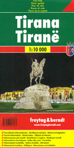
Tirana’s central districts on a handy size, indexed street plan at 1:10, 000 from Freytag & Berndt. Coverage extends from the Tirana River southwards to the Tirana Lake. Main streets and selected connecting streets are named and principal traffic arteries are highlighted. Symbols show locations of mosques and churches, hospitals, police stations, swimming pools and sports grounds, but, curiously, the plan does not indicate the central railway station! The index is on the reverse. Map legend includes English.

Product Description
Reviews/Comments
Add New
Vouchers
No voucher codes found.
Do you know a voucher code for this product or supplier? Add it to Insights for others to use.
Do you know a voucher code for this product or supplier? Add it to Insights for others to use.
 Denmark