More From Contributor

£17.95
Spiral-bound atlases, each with 50 specially selected hiking tours shown with route profiles. The routes are graded according to the difficulty of the terrain & clearly distinguished from other local hiking paths. The atlases are arranged so that each page of mapping is shown together with a page listing the routes with grading, total & intermediate times, & coordinates for special points. Route profiles also give intermediate times & indicate access to transport. The atlases include general information on emergency procedures & contact details for various services & facilities, including mountain huts. Cartography is from the Kümmerly + Frey’s 1:60, 000 hiking series, with contours at 50 or 25-metre intervals according to the terrain, enhanced by graphic relief & shading. In addition to the special routes the atlases also show all other paths marked on the K+F series, distinguishing between sign-posted hiking paths, mountain path where proper walking shoes are necessary, & alpine paths requiring special equipment. Mountain huts are marked, plus various types of accommodation: campsites, youth hostels, “ Friends of Nature” Houses, & secluded hotels & restaurants. Various symbols highlight places of interest, viewpoints, picnic sites, swimming pools, etc. The maps have a 1km grid for GPS users, with latitude & longitude shown as margin ticks. Map legend

Includes::
English.

...
Archived Product
£19.99
Popular mountain biking areas of Switzerland on waterproof & tear-resistant, contoured maps at 1:50, 000 from Hallwag, each highlighting several circuits & providing route profiles, guidance on the difficulty & overall experience, etc. Each map is printed on sturdy, waterproof & tear-resistant plastic, & uses the same detailed base as other hiking & cycling map series from the Hallwag – Kümmerly + Frey publishing house. Contours are at 25m intervals, enhanced by shading & excellent graphic relief to provide a very clear picture of the topography. An overprint highlights several mountain bike circuits from main towns & holiday resorts on the map, indicating the direction of the route. The routes are graded by colour-coding into five degrees of difficulty. Additional information provided on the map

Includes::
youth hostels, Friends of Nature houses or isolated countryside hotels, viewpoints, interesting sites, etc. The maps have a 1-km gird, although no Swiss national survey coordinates are provided for it. On the reverse each of the highlighted circuits is presented on a route-profile which also indicates “beauty & experience value” (changes in landscape, viewpoints, etc); difficulty; overall severity (length + difference in elevation + difficulty); distance; difference in altitude; time required; & the highest point. The legend for the main map & for the route profiles

Includes::
English. Brief descriptions of each circuit are in German only.


...
Archived Product
£19.99
Switzerland’s popular hiking areas on light, waterproof & tear-resistant maps from Hallwag highlighting long-distance paths: the nine national routes plus special regional routes, as well as other local hiking trails. Cartography is similar to that used both in Hallwag’s hiking atlases & in the walking series from Kümmerly + Frey at 1:60, 000 covering the whole country. The maps have contours at 50m or 25m intervals according to the terrain, enhanced by graphic relief & shading. A special feature of this series is an overprint indicating the nine national long-distance routes, plus regional long-distance trails. The overprint also shows other local paths, distinguishing between sign-posted hiking paths, mountain paths where proper walking shoes are necessary, & alpine paths requiring special equipment for glacier traverses & light climbing. Mountain huts are marked, plus various types of accommodation: campsites, youth hostels, “ Friends of Nature” houses, & secluded hotels & restaurants. Road network indicates local bus routes with stops. Railways, narrow gauge mountain railways, cable car lines, & chair lifts are shown, with various symbols highlighting places of interest, viewpoints, picnic sites, swimming pools, etc. The maps have a 1km grid for Swiss national coordinates (datum CH1903 Bessel), with latitude & longitude shown as margin ticks at 5’. * Map legend

Includes::
English.* On the reverse, an index of towns & villages

Includes::
names of geographical features such as mountains, alpine passes, glaciers, lakes, rivers, as well as places of interest. Also provided is a small road map at 1:301, 000 of a wider region around the area covered by each title.* For more information see individual descriptions.*


...
Archived Product
£19.99
Popular winter sports areas of Switzerland in a new series of waterproof & tear resistant Winter Maps from Hallwag with extensive information for ski & snowshoe tours, cross-country tracks, sledge tracks, winter hiking routes, tourist facilities, etc, printed on waterproof & tear-resistant synthetic paper. Detailed, contoured topographic base has additional colouring to indicate slope gradients between 30-35° & over 35°. Very extensive overprint highlights ski & snowshoe tours, annotated with numbers cross-referenced to descriptions provided on the reverse of the map. Also marked are easy/medium/difficult downhill slopes, hors piste routes, cross-country ski routes indicating night tracks, sledge tracks, & winter hiking paths. The maps show ski & chair lifts, cable car lines, etc, & also indicate locations of secluded hotels, Friends of Nature hostels, restaurants, ski schools for children, other sport facilities, etc. For GPS Swiss national grid is drawn at 1-km intervals. Map legend

Includes::
English. On the reverse each title has details of the ski snowshoe tours highlighted on the map. All the text here is in German but much of the information is conveyed by symbols, including the degree of difficulty, duration, etc. For snowshoe tours route profiles are also provided.

...
Archived Product
£18.99
Popular recreational areas of Switzerland on sturdy, waterproof & tear-resistant, contoured & GPS compatible maps at 1:50, 000 from the Hallwag/Kümmerly + Frey group, with each title highlighting 33 recommended hiking trails, including their route profiles, grading for the severity of the terrain & the degree of fitness it requires, etc. The cartography provides an excellent picture of the terrain through contours at 25-metre intervals enhanced by shading, graphic relief for exposed rock, & colouring for glaciers & woodlands. All local footpaths are on the maps, but the overprint specifically highlights 33 trails selected by the publishers in collaboration with Geo-tracks. The colouring of each trail indicates the degree of fitness needed, from “no physical shape required” to “extremely high level of physical fitness necessary”. The trails start near a railway station or a bus stop (the colouring of the road network indicates routes with public transport & locations of individual bus stops). The maps have the lines of the Swiss national grid at 1-km intervals. On the reverse each trail has a route profile, its grading according to severity of the terrain & the degree of fitness required to attempt it, details of length & approximate timing, the change in altitude on assent & descent, plus a brief description. Map legend

Includes::
English; all the text on the reverse is in German. Each title also

Includes::
a code for a free download onto a smartphone.USEFUL TIP: the same cartography, reduced slightly to 1:60, 000, is used in Kümmerly + Frey’s hiking series covering the whole country on light, waterproof & tear-resistant maps with highlighting for all the waymarked trails rather than, as in this series, just a selection of 33 special routes recommended by the publishers.


...
Archived Product
£14.50
Switzerland’s four main hiking areas: Bernese Oberl&, Valais/ Wallis, Graubünden with the Engadine Valleys, & the canton of Ticino on contoured & GPS compatible maps at 1:120, 000 from Kümmerly + Frey, excellent for planning walking holidays. The maps have contours at 100-metre intervals, enhanced by shading & graphic relief to provide a vivid presentation of the terrain. An overprint highlighting walking trails distinguishes between hiking paths, more strenuous mountain routes & alpine sections. Symbols indicate locations of mountain huts, Friends of Nature houses, youth hostels, campsites & selected isolated inns, interesting natural curiosities, etc. Picturesque towns or villages are prominently highlighted & the maps also show roads with public transport facilities plus, of course, railways & all forms of mountain transport (cable cars, chair lifts, etc). The maps have Swiss national grid lines at 5km intervals. Map legend

Includes::
English.

...
Archived Product
£19.99
Maps with the official “ Cycling in Switzerland” routes, published in co-operation with the Association for Transport & Environment. The aim of the series is to present a network of routes with as few problems as possible caused by motor traffic. The maps have a detailed base, with contours plus graphic relief & shading providing an excellent representation of the terrain. Routes are classified according to the density of motorized traffic, the difficulty of the terrain, & road restrictions. Unsurfaced roads are indicated, gradient marks show steep inclines, & local danger spots are highlighted. The maps show facilities for transporting cycles by train, bus, ferries, mountain railways, chair lifts, & cable cars. Border crossings indicate those open only to hikers & cyclist during daylight hours. Bike rental facilities are marked & towns with special bicycle-friendly accommodation are highlighted. Other tourist information

Includes::
various types of accommodations (campsites, youth hostels, “ Friends of Nature” houses, etc), viewpoints, picnic sites, swimming pools, & places of interest. Each title covers an area of Approx. 60 x 42 km (37 x 26 miles). The maps have a 1km grid for GPS users, with latitude & longitude shown as margin ticks. Map legend

Includes::
English. On the reverse, an index of towns & villages also lists names of geographical features such as mountains, alpine passes, glaciers, etc. Also provided is general information on the country’s long-distance cycling routes & on transporting bikes by train (text

Includes::
English).* From summer 2008 new editions of these maps will be printed on light, waterproof & tear-resistant synthetic paper.*


...
Archived Product
£19.99
Kümmerly + Frey’s hiking series of Switzerland at 1:60, 000, with most titles now printed on light, waterproof & tear-resistant plastic paper, offers a popular alternative to Swiss survey maps & cartography which many walkers find easier to follow. Coverage of the whole country is designed so that each title presents a popular hiking area. The maps have contours at 50 or 25-metre intervals according to the terrain, enhanced by graphic relief & shading. An overprint distinguishes between sign-posted hiking paths, mountain path where proper walking shoes are necessary, & alpine paths requiring special equipment. Most titles now also indicate national & regional long-distance hiking routes, each annotated with its official number. Mountain huts are marked, plus various types of accommodation: campsites, youth hostels, “ Friends of Nature” houses, & secluded hotels & restaurants. Road network indicates local bus routes with stops. Railways, narrow gauge mountain railways, cable car lines, & chair lifts are shown, with various symbols highlighting places of interest, viewpoints, picnic sites, swimming pools, etc. Each title covers an area of Approx. 60 x 42 km (37 x 26 miles). The maps have a 1km Swiss national grid, plus latitude & longitude margin ticks at 5’ intervals. * Map legend

Includes::
English.* On the reverse, an index of towns & villages

Includes::
names of geographical features such as mountains, alpine passes, glaciers, lakes, rivers, as well as places of interest. Also provided is an overview road map of surrounding region.* Please see individual entries for exact area covered by each title.


...
Archived Product
£5.99
Switzerland on three indexed touring maps at 1:200, 000 from Michelin, each with street plans of major cities showing access routes & main streets, plus a distance table. The maps also indicate places with entries in Michelin’s annual Red Guides to hotels & restaurants. Topography is presented by relief shading & colouring for woodlands, plus names of mountain ranges, peaks, passes, etc. Road network, classified according to the number of lanes, indicates motorway services & rest areas, full & partial interchanges, road width, load & height limits, steep gradients, dangerous or difficult sections, seasonal closures & entry restrictions, etc. Scenic routes are highlighted. Railways, funiculars, cable car lines, etc. are shown, as well as car ferry lines. Symbols indicate places of interest, sport & leisure facilities, etc. Names of cantons & their boundaries are marked. The maps have no geographical coordinates. The index is next to the map. Map legend

Includes::
English. Each title

Includes::
street plans of major cities showing road access to the centre & naming main streets which are also listed in a short index, plus a distance/driving times table.


...
Archived Product
£14.50
Railways & public transport map of Switzerland published jointly with the SBB (Schweizerische Bundesbahnen), showing standard & narrow gauge railways, rack railways, cable cars, chair-lifts, coach/trolley bus services, & ferries. Official timetable numbers are shown on each route & railway stations are indicated. Also highlighted are Publi Car zones: localities which have no regular public transport & in which a car rental service is provided instead. The relief shading of the base map is subdued in order to not distract from the main information, & additional symbols depict conventional features e.g. antiquities, monuments, natural features of interest, motels, campsites, spas, etc. No geographical coordinates are shown. Map legend

Includes::
English. On the reverse of the map is an extensive index of localities, which also indicates places with Mobility Car Sharing & bicycle hire facilities. The accompanying booklet, which now

Includes::
English, provides tips for traveling around the country by public transport, with website addresses & other contact details of various organizations. The booklet also

Includes::
plans of the public transport networks in 12 main cities, plus plans of their railway stations (in Zurich both the main station & Enge) indicating various facilities, including car & bike hire points, & all the nearby bus & tram stops.


...
Archived Product

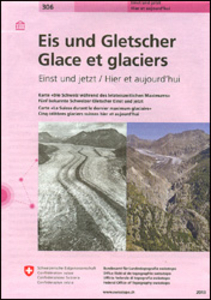
Switzerland: Ice & Glaciers Once And Today Swisstopo Map No. 306

Ice and Glaciers map in the Swisstopo’s “Once and Today” series, presenting on one side a map of Switzerland during the Last Glacial Maximum, with on the reverse topographic maps and aerial photos of the country’s five well-known glaciers to show the extent of the retreat of the ice cover. On one side is a map of the whole country at 1:540, 000 during the Last Glacial Maximum 20, 000 to 11, 500 years ago. The map has contours at 200m intervals both on the glaciers and the ice-free area and shows names numerous mountain peaks as well as locations of present day main towns. On the reverse five of the country’s well known glaciers: the Great Aletsch Glacier, the Trift Glacier, the Lower Grindelwald Glacier, the Morteratsch Glacier and the Gorner Glacier near Zermatt, are each
shown on two topographic maps, from present day and from mid-1800s, plus on two aerial photos.Map legend and the accompanying text include English.For the list of other titles in this series please click on the series link.
RIP - This product is no longer available on our network. It was last seen on 25.09.2019

This page now acts as a permanent archive for this product. Add more information using the comments box below to ensure it can still be found by future generations.

Use our search facility to see if it is available from an alternative contributor.
  • Availability: Out Of Stock
  • Supplier: Stanfords
  • SKU: 9783302103068
Availability: In Stock
£12.99

Product Description

Ice & Glaciers map in the Swisstopo’s “ Once & Today” series, presenting on one side a map of Switzerland during the Last Glacial Maximum, with on the reverse topographic maps & aerial photos of the country’s five well-known glaciers to show the extent of the retreat of the ice cover. On one side is a map of the whole country at 1:540, 000 during the Last Glacial Maximum 20, 000 to 11, 500 years ago. The map has contours at 200m intervals both on the glaciers & the ice-free area & shows names numerous mountain peaks as well as locations of present day main towns. On the reverse five of the country’s well known glaciers: the Great Aletsch Glacier, the Trift Glacier, the Lower Grindelwald Glacier, the Morteratsch Glacier & the Gorner Glacier near Zermatt, are each shown on two topographic maps, from present day & from mid-1800s, plus on two aerial photos. Map legend & the accompanying text include English. For the list of other titles in this series please click on the series link.

Reviews/Comments

Add New

Intelligent Comparison

Oooops!
We couldn't find anything!
Perhaps this product's unique.... Or perhaps we are still looking for comparisons!
Click to bump this page and we'll hurry up.

Price History

Vouchers

No voucher codes found.
Do you know a voucher code for this product or supplier? Add it to Insights for others to use.

Facebook

Jargon Buster

Ice - Frozen water, the solid state of water.
switzerland - A landlocked country in western Europe. One of the richest countries in the world
Day - The time it takes a planet or other space objects to complete one rotation.
Ice - Frozen water, Ice is cold to the touch and forms when water reaches 0 degrees centigrade.

Supplier Information

Stanfords
Stanfords was established in 1853 and opened their iconic Covent Garden flagship store in 1901. They have become the top retailer of maps, travel books and accessories in the UK and arguably offer the largest selection of maps and travel books worldwide. Famous names such as Captain Robert Falcon Scott, Ranulph Fiennes and Michael Palin have purchased from Stanfords. They now have a shop in Bristol and both stores together with other venues operate a calendar of events including talks, book signings and exhibitions. As a specialist map retailer, the map selection is comprehensive and includes road maps, street maps and walking maps from worldwide destinations, as well as a selection of world atlases and wall maps. Books include travel guides and travel literature. Stanfords also stock globes, from miniatures made of blue marble to magnificent floor-standing globes. The website features a selection of interesting articles on travel topics.
Page Updated: 2023-11-12 20:15:36

Community Generated Product Tags

Oh No! The productWIKI community hasn't generated any tags for this product yet!
Menu