More From Contributor

£20.00
Surrey in a series of cloth-backed reproductions from the Old Folding Maps of county maps published in late 19th century by Letts, Son & Co, with colouring & symbols providing a wealth of information, including towns where County Courts & Quarter Sessions are held, municipal boroughs, parliamentary county & borough boundaries with the number of returnable Members, etc. Letts county maps present each county with colouring indicating its parliamentary divisions & show a large number of smaller towns & villages. Railways are prominently highlighted; on roads “dangerous hills” are marked. Other information

Includes::
distance from London of main towns, market days, post towns, coast guard & life boat stations, etc. Each title also gives county statistics: population, area in acres, gross rental, inhabited houses, poor rate, & the number of paupers (!). Where appropriate, hachures are used to show the topography. The area outside the county boundary is not coloured but main towns plus road & rail connections are marked. Each map is backed onto cloth & presented folded in a colourful case covered with a unique design marbled paper. To see the list of all the titles in this series please click on the series link.

...
Archived Product
£140.00
Surrey, an original antique map by R. Ramble, published in London, 1821 -1844. A lithograph engraving, original colour. Map size 15 x 18.5 cm with a mount size of 33 x 39.5 cm. An attractive & uncommon miniature map surrounded by vignettes of the county's landmarks. Ramble added these vignettes to Miller's maps of 1821 that were originally published as part of Miller's New Miniature Atlas.. .. With the decorative views added these maps were republished from 1844 in Reuben Ramble's Travels Through The Counties Of England
- a child's guide to the country. Protective margin added. Antique maps from various original publishers are presented on the Stanford
...
Archived Product
£20.00
Surrey in a series of cloth-backed reproductions from the Old Folding Maps of county maps published in late 19th century by Letts, Son & Co, with colouring & symbols providing a wealth of information, including towns where County Courts & Quarter Sessions are held, municipal boroughs, parliamentary county & borough boundaries with the number of returnable Members, etc. Letts county maps present each county with colouring indicating its parliamentary divisions & show a large number of smaller towns & villages. Railways are prominently highlighted; on roads “dangerous hills” are marked. Other information

Includes::
distance from London of main towns, market days, post towns, coast guard & life boat stations, etc. Each title also gives county statistics: population, area in acres, gross rental, inhabited houses, poor rate, & the number of paupers (!). Where appropriate, hachures are used to show the topography. The area outside the county boundary is not coloured but main towns plus road & rail connections are marked. Each map is backed onto cloth & presented folded in a colourful case covered with a unique design marbled paper. To see the list of all the titles in this series please click on the series link.

...
Archived Product
£6.99
Surrey 30 Short walks is a handy pocket-sized box of 30 short walking routes in Surrey. Contained within the box are 30 cards each with a short walking route, so walkers can easily take it with them on the walk for easy reference. All of the walks featured are between 1 & 4 miles long, allowing walkers to tackle them in a morning or afternoon. Key panels give details on distance, gradient, difficulty, surface & other practical advice. ...
Archived Product
£9.99
This compact & handy guide to short walks in Surrey features walks between one & four miles long which can be covered in a morning or afternoon. There is an introduction for each walk giving background on the area, its history, wildlife & other points of interest; plus key information panels providing a summary of distance, time, gradient & ascent, level of difficulty, type of surface & access, landscape, dog friendliness, refreshments, parking & public toilets. Each walk has a highly detailed map & clear, easy-to-follow route directions. ...
Archived Product
£120.00
Surrey, an original antique map by G. Cole / J. Roper, published in London c. 1804-1810. Copperplate, original colour. Map size 23 x 17.5 cm, overall mounted size 38 x 33 cm.A detailed nineteenth-century map of Surrey published in The British Atlas; Comprising A Complete Set Of County Maps, Of England & Wales; & Plans Of Cities & Principal Towns in 1810. The map was drawn by G. Cole & engraved by John Roper for publication first in The Beauties Of England & Wales, issued in parts, from c.1804. Such was the success of the publication that the maps were re-used in other publications, as here. The maps show accurate geographical detail, including the turnpike, mail coach & principal roads, sites of Roman & other historical remains, as well as the seats of the nobility & the gentry, & market towns with their distances from London. The maps also show the division of the counties into hundreds or wapontakes. They are representative of the functional nineteenth-century approach to cartography, yet are not unattractive. Antique maps from various original publishers are presented on the Stanford ...
Archived Product
£9.99
Surrey`s landscape, shaped by the Devil`s mischief & the whims of dancing Pharisees, is home to a wealth of tales. For Surrey is a place where dragons have stalked, dripping poisoned saliva from their yellow teeth; a place where horses have sprouted wings in order to rescue bewitched villagers; a place where pumas with the gift of speech have prowled the countryside. From the legends of Stephen Langton to the marvels of Captain Salvin & his flying pig, Janet Dowling has vividly retold these myths & stories of Surrey, & brought to life the county`s heroes, villains & saints. ...
Archived Product
£18.99
The South Downs
- Central at 1:40, 000 in a series of maps printed on waterproof fabric, from Splash Maps, designed for outdoor
...
Archived Product
£12.99
The Pathfinder (R) Guide to Surrey Walks contains 28 fantastic circular walks across the county, much of which lies only a few miles away from the heart of London but which contains some of the country`s most beaufiul landscapes, including the oldest untouched area of natural woodland in the UK & the rolling contours of the North Downs. Each walk in Pathfinder (R) Guide to Surrey Walks is accompanied by clear, large-scale Ordnance Survey route maps & GPS waypoints to help you navigate your hike with ease. Exploring one of the most popular Home Counties, Pathfinder (R) Guide to Surrey Walks guides the walker to some of the best walking destinations in the county, from Box Hill & Wisley to the Devil`s Punch Bowl & the River Wey. Away from the city, Pathfinder (R) Guide to Surrey Walks presents a host of beautiful countryside walks that offer remarkable hikes with unspoilt landscapes accessible to walkers of all abilities. Pathfinder (R) Guide to Surrey Walks takes you through the North Downs & heathlands of western Surrey to locations made popular in Jane Austen`s Emma & War of the Worlds by H. G. Wells. Inside you`ll also find a wealth of helpful information accompanying each walk, including good pubs along the way, where to park before you start your walk & places of interest en route. Pathfinder (R) Guides are Britain`s best loved walking guides. They are the perfect companion for countryside walks throughout Britain. Each title features circular walks with easy-to-follow route descriptions, tried & tested by seasoned walkers & accompanied by beautiful photography & clear Ordnance Survey mapping. The routes range from extended strolls to exhilarating hikes, so there is something for everyone. ...
Archived Product
£25.00
Surrey Pevsner Architectural Guide, in a series of publications begun with the express aim of providing up-to-date guides to the most significant buildings in every part of the country, suitable for both general reader & specialist. Each volume provides an introductory overview of the architecture of the area, followed by a descriptive gazetteer arranged alphabetically by place. Whilst cathedrals & their furnishings, great country houses & their parks form the grand set pieces, the books demonstrate the enjoyable diversity of architecture in the British Isles in accounts of rural churches & farmsteads, Victorian public buildings & industrial monuments. A continuing programme of publication keeps the series up-to-date with new information on older buildings & recent architecture while maintaining the tradition of Pevsner`s own succinct accounts. Each book has over 100 photographs, mostly specially commissioned, numerous maps & plans, a glossary & indexes. ...
Archived Product

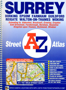
Surrey A-Z Street Atlas

Surrey Street Atlas from the Geographers` A-Z Map Company in a spiral-bound format slightly smaller than A4 and covering the whole county at 1:19, 000 (3.33” to 1 mile). More detailed mapping at 1:9, 051 (7” to 1 mile) shows town centres of Dorking, Epsom and Guildford, plus Croydon and Kingston-upon-Thames. Current edition of this title was published in 2013.To see other titles in this series of A-Z county street atlases please click on the series link. A-Z also publish street atlases in a smaller A5 paperback format covering towns and cities with their surrounding areas - for a list of titles in that series please search for SI00000932.Most A-Z county street atlases are in a spiral-bound format just smaller than A4 size, Most titles offer coverage of only the built-up areas, with
selected titles covering the whole county - as indicated in the individual descriptions and our area coverage images. Motorways plus A and B roads are highlighted by colouring and show route numbers. One way or restricted access streets, Park & Ride facilities and selected car parks are marked, as are locations of speed cameras. Also shown are selected cycleway routes. Where appropriate, A and B roads are annotated with selected house numbers for easier identification of addresses. Railway lines are shown with stations and level crossings. Colouring indicates different types of buildings: educational, hospitals and healthcare, industrial, leisure and recreational, shopping centres and markets, public buildings, and places of interest. Symbols mark locations of facilities usually
indicated on street mapping: post offices, emergency services, public toilets, etc. Also marked are postcode and local authority boundaries. Each page has the lines and coordinates of the British National Grid. All the titles have a comprehensive index including, unless specified to the contrary in the description, separate entries for places of interest such as cultural and sport or recreational facilities, historical sites, nature reserves and gardens. Many titles include a separate list of hospitals and hospices in the area covered by the atlas.
RIP - This product is no longer available on our network. It was last seen on 25.09.2019

This page now acts as a permanent archive for this product. Add more information using the comments box below to ensure it can still be found by future generations.

Use our search facility to see if it is available from an alternative contributor.
  • External links may include paid for promotion
  • Availability: Out Of Stock
  • Supplier: Stanfords
  • SKU: 9781782570028
Availability: In Stock
£13.95

Product Description

Surrey Street Atlas from the Geographers` A-Z Map Company in a spiral-bound format slightly smaller than A4 & covering the whole county at 1:19, 000 (3.33” to 1 mile). More detailed mapping at 1:9, 051 (7” to 1 mile) shows town centres of Dorking, Epsom & Guildford, plus Croydon & Kingston-upon-Thames. Current edition of this title was published in 2013. To see other titles in this series of A-Z county street atlases please click on the series link. A-Z also publish street atlases in a smaller A5 paperback format covering towns & cities with their surrounding areas
- for a list of titles in that series please search for SI00000932. Most A-Z county street atlases are in a spiral-bound format just smaller than A4 size, Most titles offer coverage of only the built-up areas, with selected titles covering the whole county
- as indicated in the individual descriptions & our area coverage images. Motorways plus A & B roads are highlighted by colouring & show route numbers. One way or restricted access streets, Park & Ride facilities & selected car parks are marked, as are locations of speed cameras. Also shown are selected cycleway routes. Where appropriate, A & B roads are annotated with selected house numbers for easier identification of addresses. Railway lines are shown with stations & level crossings. Colouring indicates different types of buildings: educational, hospitals & healthcare, industrial, leisure & recreational, shopping centres & markets, public buildings, & places of interest. Symbols mark locations of facilities usually indicated on street mapping: post offices, emergency services, public toilets, etc. Also marked are postcode & local authority boundaries. Each page has the lines & coordinates of the British National Grid. All the titles have a comprehensive index including, unless specified to the contrary in the description, separate entries for places of interest such as cultural & sport or recreational facilities, historical sites, nature reserves & gardens. Many titles include a separate list of hospitals & hospices in the area covered by the atlas.

Reviews/Comments

Add New

Intelligent Comparison

Oooops!
We couldn't find anything!
Perhaps this product's unique.... Or perhaps we are still looking for comparisons!
Click to bump this page and we'll hurry up.

Price History

Vouchers

No voucher codes found.
Do you know a voucher code for this product or supplier? Add it to Insights for others to use.

Facebook

Jargon Buster

Car - A machine used for transport which runs on roads
speed - A measurement of how fast an object travels between two points
Size - is the measurement of how big an object is in space.
Individual - A single separate item or person.

Supplier Information

Stanfords
Stanfords was established in 1853 and opened their iconic Covent Garden flagship store in 1901. They have become the top retailer of maps, travel books and accessories in the UK and arguably offer the largest selection of maps and travel books worldwide. Famous names such as Captain Robert Falcon Scott, Ranulph Fiennes and Michael Palin have purchased from Stanfords. They now have a shop in Bristol and both stores together with other venues operate a calendar of events including talks, book signings and exhibitions. As a specialist map retailer, the map selection is comprehensive and includes road maps, street maps and walking maps from worldwide destinations, as well as a selection of world atlases and wall maps. Books include travel guides and travel literature. Stanfords also stock globes, from miniatures made of blue marble to magnificent floor-standing globes. The website features a selection of interesting articles on travel topics.
Page Updated: 2023-11-12 20:15:36

Community Generated Product Tags

Oh No! The productWIKI community hasn't generated any tags for this product yet!
Menu